McArthur–Burney Falls Memorial State Park is the second oldest state park in the California State Parks system, located approximately 6 miles (9.7 km) north of Burney, California. The park offers camping, fishing, watersports, hiking and horseback riding facilities. The park is mainly known for the waterfall, Burney Falls, at the entrance of the park. Wildlife in the park includes bass, trout, Steller's jay, squirrels, woodpeckers, deer, and on rare occasion, black bear.

The Piney River is a stream that drains a portion of Tennessee's Cumberland Plateau generally known as Walden Ridge. The Piney River rises near the Rhea County – Bledsoe County line and is referred to as Piney Creek in its upper reaches roughly until its confluence with Duskin Creek. Its major tributary, Little Piney Creek, flows over two spectacular waterfalls which are located in Piney Falls State Natural Area near the community of Grandview. A tributary of Little Piney Creek is Soak Creek, Tennessee's newest State Scenic River. The confluence of the two streams occurs below the falls of the smaller stream in an area referred to as "Shut-in Gap". The stream flows out of the gap and is bridged by State Route 68 just before that road begins its steep climb up the Cumberland Escarpment onto Waldens Ridge. The stream flows north of Spring City, Tennessee and becomes slack just east of the town at a headland of Watts Bar Lake, an impoundment of the Tennessee River formed by the Tennessee Valley Authority's Watts Bar Dam project. The mouth of the Piney is one of the larger bays of Watts Bar Lake and contains several small islands.

Cloudland Canyon State Park is a 3,485 acres (14.10 km2) Georgia state park located near Trenton and Cooper Heights on the western edge of Lookout Mountain. One of the largest and most scenic parks in Georgia, it contains rugged geology, and offers visitors a range of vistas across the deep gorge cut through the mountain by Sitton Gulch Creek, where the elevation varies from 800 to over 1,800 feet. Views of the canyon can be seen from the picnic area parking lot, in addition to additional views located along the rim trail. At the bottom of the gorge, two waterfalls cascade across layers of sandstone and shale, ending in small pools below.

The Justin P. Wilson Cumberland Trail State Park is a Tennessee hiking trail following a line of ridges and gorges along the eastern escarpment of the Cumberland Plateau in Tennessee. The trail begins at Cumberland Gap National Historical Park and ends at Chickamauga and Chattanooga National Military Park and Prentice Cooper Wildlife Management Area just outside Chattanooga, Tennessee. The trail travels through 11 Tennessee counties and two time zones.

The Paddy Creek Wilderness is a 7,019-acre (28.40 km2) wilderness area in the U.S. state of Missouri, United States. The United States Congress designated it wilderness in 1983. Paddy Creek Wilderness is located within the Houston-Rolla Ranger District, of the Mark Twain National Forest, 10 miles (16 km) northwest of Licking, Missouri. It was named for Big and Little Paddy Creeks that run through the area. The Paddy Creek Wilderness is one of eight wilderness areas protected and preserved in Missouri. Big Piney Trail is a 17-mile (27 km) long loop that traverses this wilderness area and is popular among avid backpackers. The 17-mile (27 km) loop trail can be hiked as a 10-mile (16 km) stretch or the 7.5-mile (12.1 km) south section. The trails are rugged and can be challenging for the inexperienced or unprepared hiker. Horseback riding is also common on the Piney Creek Trail. The Paddy Creek Recreation Area is nearby, and offers many camping amenities. There are many single sites, and a few double sites available. There is also fishing access on the Big Piney River, via a trail access from the campground.

Monkman Provincial Park is a provincial park in British Columbia, southwest of Tumbler Ridge and northeast of Hansard. Like Monkman Pass, Monkman Lake, Monkman Creek and Monkman Falls, it was named after Alexander Monkman.

Mount Le Conte is a mountain in Sevier County, Tennessee located in the Great Smoky Mountains National Park. At 6,593 ft (2,010 m) it is the third highest peak in the national park, behind Clingmans Dome and Mount Guyot. It is also the highest peak that is completely within Tennessee. However, from its immediate base to its summit, Mount Le Conte is one of the highest peaks in the Appalachian Mountains rising 5,301 ft from its base, near Gatlinburg, Tennessee.

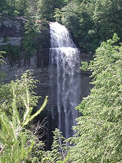
The Rainbow Falls Trail is an American hiking trail in the Great Smoky Mountains National Park, in Sevier County, Tennessee. The trail ascends Mount Le Conte, the tallest mountain east of the Mississippi River, and passes Rainbow Falls before absorbing the Alum Cave Trail and terminating near the LeConte Lodge.

The Abrams Falls Trail is an American hiking trail, in the Great Smoky Mountains National Park of Blount County, Tennessee. The trail runs parallel to Abrams Creek and passes Abrams Falls, one of the most voluminous waterfalls in the national park, before terminating at a junction with the Hatcher and Hannah Mountain trails.

Difficult Run is a 15.9-mile-long (25.6 km) tributary stream of the Potomac River in Northern Virginia in the United States. The area has had many historical uses dating back to the early 1800s. Today, the area is used recreationally by visitors interested in the watershed's variety of options including hiking, biking, fishing, boating, climbing, and bird watching. The wildlife at Difficult Run is vast as 163 different species can be seen depending on the season. There are 41 different soil types found on the trail and alongside the stream. The stream is part of the greater 57.7- square-mile Drainage basin, or watershed, located in the north-central portion of Fairfax County and drains directly to the Potomac River.

Douglas Falls are a 60-foot waterfall located in Buncombe County, North Carolina, United States. It is on a tributary of Waterfall Creek which flows into the Ivy River, and it is within the Big Ivy section of the Pisgah National Forest. The stream flows off the slope of Craggy Pinnacle, starting just below the Blue Ridge Parkway. It is surrounded by a forest of very large Eastern Hemlock trees, which are dead following attack by the Hemlock Wooly Adelgid. Visitors should be very careful when visiting this falls, as the dead Hemlocks will start to decay and fall within the next few years.

The Priest (DePriest) is a mountain in Nelson County, Virginia. The peak of the mountain is the highest point in the county. The mountain is on a spur off the main Blue Ridge Mountains, about 3.5 miles (5.5 km) east of Maintop Mountain, located in the Priest Wilderness of the George Washington National Forest.

Scott's Gulf is a canyon situated along the Caney Fork in White County, Tennessee, in the southeastern United States. The canyon stretches for approximately 18 miles (29 km) as the Caney Fork drops from the top of the Cumberland Plateau down to the eastern Highland Rim. This remote section of the river is home to a wilderness area consisting of a largely undisturbed deciduous forest, numerous waterfalls, caves and other geological formations, and Class IV and Class V whitewater rapids.

Ozone Falls State Natural Area is a state natural area in Cumberland County, Tennessee, located in the Southeastern United States. It consists of 43 acres (0.17 km2) centered on Ozone Falls, a 110-foot (34 m) plunge waterfall, and its immediate gorge along Fall Creek. Because of its picturesque beauty and easy access, Disney selected Ozone Falls for filming scenes for the live action movie The Jungle Book. The area is managed by the Tennessee Department of Environment and Conservation and maintained by Cumberland Mountain State Park. It is also part of the Cumberland Trail State Park.
Pocket wilderness is a name used by Bowater corporation and the State of Tennessee for any of several tracts of Bowater-owned private land on and near the Cumberland Plateau that the company set aside beginning in 1970 "for preservation in its natural state, with no logging or development other than hiking trails permitted within its boundaries" and registered as Tennessee state natural areas. Several areas formerly managed as Bowater pocket wilderness are now incorporated into state-owned natural areas or National Park Service sites.

The Eagles Nest Wilderness is a U.S. Wilderness Area located in the Gore Range near Vail, Copper Mountain, Frisco, Silverthorne, and Heeney, in Summit and Eagle Counties Colorado. Eagles Nest Wilderness falls within the jurisdiction of Dillon Ranger District and Holy Cross Ranger District, White River National Forest. The 135,114-acre (546.79 km2) wilderness with 180 miles (290 km) of trails was established in 1976. In 2010, additional lands were proposed for wilderness protection under the Hidden Gems proposal, affecting Elliot Ridge, Tenmile, and Lower Piney areas of Summit and Eagle Counties.

Rockhouse Falls, is a 125 feet (38 m) plunge waterfall that marks Rockhouse Creek's confluence with Cane Creek. The waterfall, which shares a plungepool with Cane Creek Falls, is visible from the Gorge Trail and from the base of the Cane Creek Gorge. The falls are located near Spencer, Tennessee in Fall Creek Falls State Park.

Cane Creek Falls is an 85-foot (26 m) plunge waterfall located along Cane Creek near Spencer, Tennessee, above the creek's confluence with Rockhouse Creek and Fall Creek. The waterfall is visible from the Gorge Trail and from the base of the Cane Creek Gorge, which can be accessed via the Cable Trail. The falls are located in Fall Creek Falls State Park.
The Tennessee River Gorge Trust is a non-profit land trust conservation group acquiring and maintaining conservation areas, building trails, and conducting environmental studies and education programs in the Tennessee River Gorge near Chattanooga, Tennessee. It is involved in preserving natural areas along the Tennessee River. The group was established in 1981.