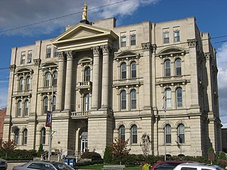
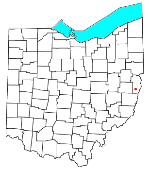
Jefferson County is a county located in the U.S. state of Ohio. As of the 2020 census, the population was 65,249. Its county seat is Steubenville. The county is named for Thomas Jefferson, who was vice president at the time of its creation.

Weems, also known as Smithfield Station, is a small unincorporated community in northwestern Wells Township, Jefferson County, Ohio, United States. The town began with a post office and butcher shop. The town still claims an active community church today. It is located near State Route 151.

State Route 152 is the designation for two segments of a state highway in Jefferson County, Ohio. The southern segment, which is 6.18 miles (9.95 km) long, runs from SR 150 in Dillonvale to SR 151 in Smithfield. The northern segment, which is 20.20 miles (32.51 km) long, runs from an interchange with U.S. Route 22 (US 22) in Bloomingdale to SR 7 in Empire.

Hopewell is a small unincorporated community in northern Warren Township, Jefferson County, Ohio, United States. It is located about four miles northwest of Tiltonsville at 40°13′21″N80°42′35″W. Its FIPS place code is 36302, and its elevation is 1200 feet above sea level. The community is part of the Weirton–Steubenville, WV-OH Metropolitan Statistical Area.

Smithfield Township is one of the fourteen townships of Jefferson County, Ohio, United States. The 2020 census found 3,011 people in the township.

Wolf Run is an unincorporated community in eastern Springfield Township, Jefferson County, Ohio, United States. It has a post office with the ZIP code 43970. The stream of Wolf Run, which flows northward past the community, is a tributary of Goose Creek, which in turn flows southward to meet Cross Creek in Harrison County's German Township, which in turn flows eastward to meet the Ohio River at Mingo Junction.
Greentown is an unincorporated community in eastern Smithfield Township, Jefferson County, Ohio, United States. It lies approximately 2 miles (3.2 km) south of Smithfield, on a small road. Part of the Dry Fork of Short Creek, a stream that meets the Ohio River at Rayland, flows past the community. It is located 11.7 miles (18.8 km) southwest of Steubenville, the county seat of Jefferson County. The community is part of the Weirton–Steubenville, WV-OH Metropolitan Statistical Area.

The Weirton–Steubenville, WV–OH Metropolitan Statistical Area, also known as the Upper Ohio Valley, is a metropolitan statistical area consisting of two counties in the Northern Panhandle of West Virginia and one in Ohio, anchored by the cities of Weirton and Steubenville. As of the 2020 census, the MSA had a population of 116,903. This puts it at 334th largest in the United States. It is also included in the larger Pittsburgh–New Castle–Weirton, PA–OH–WV Combined Statistical Area.
Rush Run is an unincorporated community in Warren Township, Jefferson County, Ohio, United States. It is mainly around the area of Rush Run Road also known as County Road 17. It is named for David Rush who settled in that area in 1798.
Buckeye Local School District is a public school district based in Dillonvale, Ohio, United States. The school district includes all of Mount Pleasant, Smithfield, Warren, and Wells townships in southern Jefferson County as well as very small portions of Cross Creek, Steubenville, and Wayne townships in central Jefferson County. A portion of Short Creek Township in southeastern Harrison County and Pease Township in northeastern Belmont County also lie within the district.

Unionport is a small unincorporated community in Jefferson County, Ohio. It is best known as the birthplace of millionaire, Helen Brach, who was the center of media attention in 1977, when she disappeared. Unionport is located on the banks of the Cross Creek, a large tributary of the Ohio River approximately 20 miles east.
Annapolis is an unincorporated community in Salem Township, Jefferson County, in the U.S. state of Ohio.
Bradley is an unincorporated community in Jefferson County, in the U.S. state of Ohio.
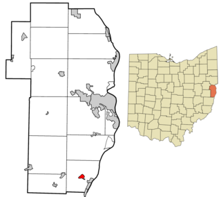
Connorville is an unincorporated community and census-designated place in southern Jefferson County, Ohio, United States. The population was 160 at the 2020 census. It is part of the Weirton–Steubenville metropolitan area.
Emerson is an unincorporated community in Jefferson County, in the U.S. state of Ohio. Emerson is usually considered to be the area that runs from the border of Mount Pleasant, Ohio to the junction between Route 250 and Route 150, and then when both Jefferson and Belmont 5 run into Pleasant Grove, Ohio on Route 250, and then finally when Township Road 128 splits into both the latter and Pinewood Drive, which then runs into Harrisville, Ohio.
Fernwood is an unincorporated community in Jefferson County, in the U.S. state of Ohio.
Osage is an unincorporated community in Jefferson County, in the U.S. state of Ohio.
Pravo is an unincorporated community in Jefferson County, in the U.S. state of Ohio.
Altamont is an unincorporated community in Steubenville Township, Jefferson County, Ohio, United States. It is located south of Steubenville and just east of Hillsboro along Wilson Avenue, at 40°20′00″N80°37′03″W.
Broadacre is an unincorporated community in Wayne Township, Jefferson County, Ohio, United States. It is located about 2.5 miles (4.0 km) northeast of Bloomingdale at the intersection of Ohio State Route 152 and Township Route 166, at 40°21′58″N80°46′59″W.

