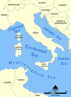
The Tyrrhenian Sea is part of the Mediterranean Sea off the western coast of Italy. It is named for the Tyrrhenian people, identified since the 6th century BCE with the Etruscans of Italy.

Scott Island is a small uninhabited island of volcanic origin in the Ross Sea, Southern Ocean, 505 kilometres (310 mi) northeast of Cape Adare, the northeastern extremity of Victoria Land, Antarctica. It is 565 metres (618 yd) long north-south, and between 130 metres (140 yd) and 340 metres (370 yd) wide, reaching a height of 54 metres (177 ft) and covering an area of 4 hectares. Haggits Pillar, a stack reaching 62 metres (203 ft) in height and measuring 50 metres (55 yd) in diameter, yielding an area of less than 0.2 hectares, is located 250 metres (270 yd) west of the island. The island has two small coves with beaches, the rest of the island being surrounded by high cliffs. One of the coves is on the northeastern coast and the other opposite Haggitts Pillar on the western coast of the island.

The Sea Shepherd Conservation Society (SSCS) is a self-described non-profit, marine conservation organization based in Friday Harbor on San Juan Island, Washington, in the United States.

Paul Franklin Watson is a Canadian-American marine wildlife conservation and environmental activist, who founded the Sea Shepherd Conservation Society, an anti-poaching and direct action group focused on marine conservation and marine conservation activism; a group accused of Eco-terrorism by both the Japanese government and Greenpeace. He is a citizen of Canada and the United States.

Shepherd's beaked whale, also commonly called Tasman's beaked whale or simply the Tasman whale, is a cetacean of the family Ziphiidae. The whale has not been studied extensively. Only four confirmed at sea sightings have been made and 42 strandings recorded. It was first known to science in 1937, being named by W. R. B. Oliver after George Shepherd, curator of the Wanganui Museum, who collected the type specimen near Ohawe on the south Taranaki coast of New Zealand's North Island, in 1933.

The Amundsen Sea, an arm of the Southern Ocean off Marie Byrd Land in western Antarctica, lies between Cape Flying Fish to the east and Cape Dart on Siple Island to the west. Cape Flying Fish marks the boundary between the Amundsen Sea and the Bellingshausen Sea. West of Cape Dart there is no named marginal sea of the Southern Ocean between the Amundsen and Ross Seas. The Norwegian expedition of 1928–1929 under Captain Nils Larsen named the body of water for the Norwegian polar explorer Roald Amundsen while exploring this area in February 1929.

West Mouse is an islet lying 1.1 kilometres (0.68 mi) off the north-west coast of Anglesey, Wales. Its maximum dimensions are 92 by 82 metres, with an area of 1.2 acres (4,900 m2).

Pine Island Glacier (PIG) is a large ice stream, and the fastest melting glacier in Antarctica, responsible for about 25% of Antarctica's ice loss. The glacier ice streams flow west-northwest along the south side of the Hudson Mountains into Pine Island Bay, Amundsen Sea, Antarctica. It was mapped by the United States Geological Survey (USGS) from surveys and United States Navy (USN) air photos, 1960–66, and named by the Advisory Committee on Antarctic Names (US-ACAN) in association with Pine Island Bay.

The MY Bob Barker is a ship owned and operated by the Sea Shepherd Conservation Society, named after American television game show host and animal rights activist Bob Barker, whose donation of $5 million to the society facilitated the purchase of the ship. She first started operating for the group in late 2009 / early 2010 in its campaign against whaling by Japanese fisheries. In October 2010, Sea Shepherd stated that Bob Barker had completed a major refit in Hobart, Tasmania. Hobart is now the ship's honorary home port.

The Sea Shepherd Conservation Society engages in various demonstrations, campaigns, and tactical operations at sea and elsewhere, including conventional protests and direct actions to protect marine wildlife. Sea Shepherd operations have included interdiction against commercial fishing, shark poaching and finning, seal hunting and whaling. Many of their activities have been called piracy or terrorism by their targets and by the ICRW. Sea Shepherd says that they have taken more than 4,000 volunteers on operations over a period of 30 years.

MV John Paul DeJoria is a cutter class vessel owned and operated by the Sea Shepherd Conservation Society. She is being used in their direct action campaigns against illegal fisheries activities.
MYFarley Mowat is a cutter owned and operated by the Sea Shepherd Conservation Society. She is being used in their direct action campaigns against whaling and against illegal fisheries activities.

The MV Sharpie is a cutter class vessel owned and operated by the Sea Shepherd Conservation Society since December 2017. She is being used in their direct action campaigns against illegal fisheries activities.
Buninga Island is an inhabited island in Shefa Province of Vanuatu in the Pacific Ocean. The island is a part of Shepherd Islands archipelago.

Tongariki Island is an inhabited island in Shefa Province of Vanuatu in the Pacific Ocean. The island is a part of Shepherd Islands archipelago.

Lamen Island is an inhabited island in Shefa Province of Vanuatu in the Pacific Ocean. The island is a part of Shepherd Islands archipelago.
Ewose is a small uninhabited island in the Shefa Province of Vanuatu in the Pacific Ocean.
Falea is a small uninhabited island in the Pacific Ocean, a part of the Shepherd Islands archipelago in the Shefa Province of Vanuatu.

Pingvin Rocks is the group of rocks in Morton Strait off the northeast coast of Snow Island in the South Shetland Islands, Antarctica extending 670 m in west–east direction and 300 m in south–north direction. The area was visited by early 19th-century sealers.
Pingvin means "penguin" in several languages. It may refer to:


