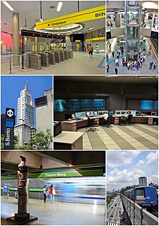
The São Paulo Metro, commonly called the Metro or Companhia do Metropolitano de São Paulo (CMSP), is one of the urban railways that serves the city of São Paulo, alongside the São Paulo Metropolitan Trains Company (CPTM), forming the largest metropolitan rail transport network of Latin America. The six lines in the metro system operate on 96.0 kilometres (59.7 mi) of route, serving 84 stations. The metro system carries about 4,700,000 passengers a day.

Cruzeiro is a city in the state of São Paulo in Brazil. It is located about 220 km (137 mi) from the state capital. It is part of the Metropolitan Region of Vale do Paraíba e Litoral Norte. The population is 81,082 in an area of 305.70 km².

Companhia Paulista de Trens Metropolitanos (CPTM) is a commuter rail company owned by the São Paulo State Department for Metropolitan Transports. It was created in May 28, 1992 from several railroads that already existed in Greater São Paulo, Brazil.
Nordeste Linhas Aéreas Regionais was a regional airline based in Brotas, Salvador, Bahia, Brazil which operated scheduled passenger services in northeast and southeast Brazil. Its main base was Deputado Luís Eduardo Magalhães International Airport, Salvador.

União dos Palmares is a municipality located in the Brazilian state of Alagoas. Its population was 59,369 (2005) and its area is 428 km². Surrounding agricultural land is largely dedicated to sugar cane and cattle. At one time, when the city was an active rail stop with regular passenger service, it was named simply União due to its rail junction joining Alagoas and Pernambuco. The name was changed in 1944 to reflect its historic significance. The city is increasingly seeing domestic and foreign tourist drawn by historical and natural features that are now protected in Parque Nacional Serra da Barriga and Parque Memorial Quilombo dos Palmares.

Gramado is a small tourist city, southeast of Caxias do Sul and east of Nova Petrópolis in the southern Brazilian state of Rio Grande do Sul, in the Serra Gaúcha region. The city was originally settled by Azorean descendants and later received a contingent of German and Italian immigrants. Gramado is one of the cities along the scenic route known as Rota Romântica.

Ciro Ferreira Gomes, often known monomyously as Ciro, is a Brazilian politician, lawyer, and academic, affiliated with the Democratic Labor Party (PDT). He was the PDT's presidential candidate in the 2018 Brazilian election.

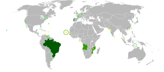
CP — Comboios de Portugal, EPE is a state-owned company which operates passenger trains in Portugal. Before June 2009, CP stood for Caminhos de Ferro Portugueses although the company has been using its current designation as a brand name since 2004.

Companhia Paulista de Estradas de Ferro (CPEF) was a Brazilian railway company located in the state of São Paulo. It was known for its high standard of quality in customer service.
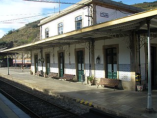
The Tua Railway Station (Portuguese: Estação Ferroviária do Tua is northern Portuguese railway station located in the civil parish of Castanheiro do Norte e Ribalonga, in the municipality of Carrazeda de Ansiães, close to the confluence of the Douro and the Tua. Although the station is still served by Comboios de Portugal main line trains on the Douro line to/from Porto.
Forquilha is a municipality in the state of Ceará in the Northeast region of Brazil.
Line 3 (Red) of the São Paulo Metro covers the stretch of the metro network between Palmeiras-Barra Funda and Corinthians-Itaquera. It was formerly called the East-West Line. Line 3 is the busiest in the system.
Cariri Metro is a 13.9-kilometer (8.6 mi), nine station diesel commuter rail line in the Cariri region of southern Ceará state, Brazil. It is operated by Companhia Cearense de Transportes Metropolitanos, which also operates the Fortaleza Metro. It is expected to transport about 5,000 passengers per day. The line went into operation on an experimental basis on 1 December 2009, and went into regular service in 2010.

Ernesto Carneiro Ribeiro was a Brazilian physician, teacher, linguist and educator. His main work is Serões gramaticais, a grammar of Brazilian Portuguese language.
Pedro Victor Delmino da Silva, known as Pedrinho, is a Brazilian professional footballer who plays as a forward for Corinthians.
Posto da Mata is a district of the municipality of Nova Viçosa in the state of Bahia, Brazil. The name literally means a station in the woods, as there was a train station in the middle of the Atlantic forest that connected the south of the state of Bahia with the east of Minas Gerais, serving as a place to recharge the fuel.
The 2019 season is the 109th season in the history of Sport Club Corinthians Paulista.

Ramal da Lousã is a railway line which connects the stations of Coimbra-B, on the Linha do Norte, and Coimbra, in Portugal. It was opened by the Companhia Real dos Caminhos de Ferro Portugueses, under the name Ramal de Coimbra, on 18 October 1885, and was extended to Lousã on 16 December 1906, and to Serpins on 10 August 1930.

Ramal de Matosinhos, originally called Ramal de Leixões, was a metre-gauge railway line which connected the stations of Senhora da Hora, on the Linha do Porto à Póvoa e Famalicão, to the Port of Leixões, in Portugal. It was built in 1884 to connect the port to the São Gens quarry. Later, it was adapted to passenger and freight transport. Commercial service began on the 6 May 1893. The line was closed on 1 July 1965. In the 2000s, part of the trackbed was used for the construction of Porto Metro Line A.