
Icém is a municipality in the northern part of the state of São Paulo in Brazil. The population is 8,304 in an area of 362.59 km². It is part of the Microregion of São José do Rio Preto. It is also known as Princesa do Vale, or "Princess of the Valley." Icem is situated near the important urban centers of São José do Rio Preto, Olímpia, Catanduva, and Mirassol. The Marimbondo Dam, which forms a big reservoir in the Rio Grande, is situated close to Icém.

Baixo Guandu is a municipality located in the Brazilian state of Espírito Santo that was founded on April 10, 1935 and established as a city on June 8, same year. The city's celebration day is April 10. Its population was 31,132 (2020) and its area is 918 km². The area is most well known for its exports of coffee, especially from the high mountains of the district of Alto Mutum Preto. The main watercourse through the municipality is the Rio Doce river whose basin is composed of 222 municipalities.
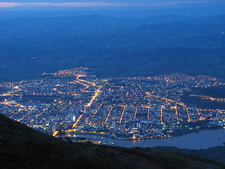
Governador Valadares is a Brazilian municipality in the countryside of Minas Gerais. In 2020, its population was 281,046 inhabitants, thus being the ninth most populated city in the state. It is an economical axis of the middle valley of the Doce River, having a significant influence on the east and northeast portion of Minas Gerais and local authorities of the state of Espírito Santo. Governador Valadares sits on the bank of the Doce River, 324 km from Belo Horizonte, the state's capital. Governador Valadares has an area of about 2 342 km2, of which only 58 km2 is urban area.

The Doce River is a river in southeast Brazil with a length of 853 kilometres (530 mi). The river basin is economically important. In 2015, the collapse of a dam released highly contaminated water from mining into the river, causing an ecological disaster.

Ipatinga is a municipality in eastern Minas Gerais state, Brazil. The city was founded on 29 April 1964 and covers a total area of 164.8 km2 (63.6 sq mi). Its population is 227,731 as of 2022. It is part of the Vale do Aço metropolitan area.

The Maxakalían languages were first classified into the Jê languages. It was only in 1931 that Čestmír Loukotka separated them from the Jê family. Alfred Métraux and Curt Nimuendajú considered the Maxakalían family isolated from others. John Alden Mason suggests a connection with the Macro-Jê stock, confirmed by Aryon Rodrigues.

Purian is a pair of extinct languages of eastern Brazil:

Esporte Clube Democrata, usually known simply as Democrata de Governador Valadares, Democrata-GV, or just Democrata, is a traditional Brazilian football club from Governador Valadares, Minas Gerais state.

Timóteo is a Brazilian municipality in the state of Minas Gerais, located by the Piracicaba River. The population as of 2020 was 90,568 inhabitants. The city is situated in the metropolitan area of the Steel Valley. It is the hometown of Aperam South America, a steel factory specialized in the production of stainless steel, now named Aperam.

Dionísio is a municipality in the state of Minas Gerais, Brazil. The city belongs to the mesoregion Metropolitana de Belo Horizonte and to the microregion of Itabira. As of 2020, the estimated population was 7,609.

Rio Piracicaba is a Brazilian municipality located in the state of Minas Gerais. The city belongs to the mesoregion Metropolitana de Belo Horizonte and to the microregion of Itabira. It has two rural districts: Conceição de Piracicaba and Padre Pinto. As of 2020, the estimated population was 14,332.

The Piracicaba River is a river of São Paulo state in southeastern Brazil. It is a tributary of the Tietê River, which it joins in the reservoir created by Barra Bonita Dam. There is also another Piracicaba river in the state of Minas Gerais, named after the one from São Paulo state, since the early colonizers of Minas Gerais largely came from São Paulo.

Vale do Rio Doce is one of the twelve mesoregions of the Brazilian state of Minas Gerais. It is composed of 102 municipalities, distributed across 7 microregions.

The Rio Doce State Park is a state park in the state of Minas Gerais, Brazil. It protects a large remnant of Atlantic Forest, and includes a system of lagoons rich in species of native fish.
The Calado Station, also known as Coronel Fabriciano Station, was a railway station that operated as a passenger and loading and unloading terminal in the Brazilian municipality of Coronel Fabriciano, in the countryside of the state of Minas Gerais. It was inaugurated on June 9, 1924, being at the time one of the three largest stations of the Vitória-Minas Railway (EFVM). Around it was established the urban core that gave rise to the headquarters of the then-subordinated district to Antônio Dias, emancipated in 1948.

The Caladinho Stream is a watercourse that rises and flows in the Brazilian municipality of Coronel Fabriciano, in the state of Minas Gerais. The source is located near the Caladinho neighborhood and it runs for about 12 kilometers to its mouth in the Piracicaba River through the Industrial Novo Reno, Universitário, Aparecida do Norte, Morada do Vale, Aldeia do Lago and Santa Terezinha II neighborhoods. Its sub-basin covers 9 km2.

The Doce River Basin is located in the southeastern region of Brazil. According to the Doce River Basin Committee (CBH-Doce), it belongs to the Southeast Atlantic hydrographic region, has a drainage area of 86,175 square kilometers and covers all or part of 229 municipalities. 86% of the basin's area belongs to the state of Minas Gerais, in the Doce River Valley, and 14% to Espírito Santo.

