
The Musi River is located in southern Sumatra, Indonesia.

Maro River also known as Sungai Merauke and Merauke-rivier, Merauki River flows in Merauke Regency, Papua Province, Indonesia. It is located just to the west of the Bensbach River of Western Province, Papua New Guinea.

Ostayır is a village and municipality in the Yardymli Rayon of Azerbaijan, in the southern part of the country, 220 km southwest of the capital Baku. This village has a population of 1,611. Population sustains itself by agricultural activities.
The Pulau River is a major river in the south of Papua province of Indonesia. With a total length of 403 km (250 mi).
The Jacaraípe River is a river located in the state of Espírito Santo in eastern Brazil, 900 km southeast of the capital Brasília.

Sampit River or Mentaya River is a river of Central Kalimantan, Borneo, Indonesia. The river takes its name from the town of Sampit which lies on the river not far from the Java Sea. Near the mouth of the river is a noted beach park named "Pandaran Beach". The Sampit flows into the Java Sea at 2°58′20″S113°2′23″E.

Benanain River is a river of western Timor, Indonesia. This river is the longest and the largest di the West Timor area, with a length of 132 km. The river is located in three regencies: Malaka, Timor Tengah Utara and Timor Tengah Selatan, province East Nusa Tenggara, Indonesia. The upstream rises from Mount Mutis, flowing in the southeast direction until discharging to Timor Sea near Besikama.

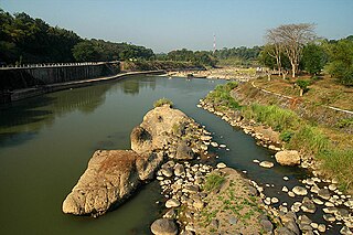
Manuk River is a river in West Java, Indonesia, about 170 km east of the capital Jakarta.

Porong River is a river flowing through Sidoarjo, East Java, Indonesia, about 700 km east of the capital Jakarta. It is one of the main branches of the Brantas River that discharges into Bali Sea, close to the Madura Strait, and is the main outlet for the Lusi mudflow.
The Progo River is a river in southern central Java, Indonesia. The river passes through two provinces; Central Java and Yogyakarta Special Region. The source of the river is on the slopes of Mount Sindoro, Central Java.
Bardon Park is a park overlooking the Swan River in Maylands, suburb of Perth, Western Australia. It is considered one of Perth's most picturesque parks.

Mount Greenly is a mountain in Australia located in the state of South Australia on the Eyre Peninsula in the gazetted locality of Coulta. The top of Mount Greenly is 305 metres (1,001 ft) above sea level.

Coyoles Central is a village in the municipality of Olanchito in Honduras. It is located in the department of Yoro, in the central part of Honduras, 160 km north of the capital Tegucigalpa. Coyoles Central initially served as a company town for workers of Standard Fruit Company, and was one of the principle settings in the book Prisión Verde, by Ramón Amaya Amador.

Simba is a small village along the Mombasa Road (A109), some 140 kilometers southeast of Nairobi, between Emali and Kiboko. It is situated on the boundary of the Makueni and Kajiado counties. The Simba Plains are located some 10 kilometers due south.

Punta Banco is a small seaside village in Costa Rica. It is located in the province of Puntarenas, in the southeastern part of the country, 210 km southeast of the capital of San José. The terrain inland is mainly hilly, but in the northwest is flat. The highest point nearby is 277 meters above sea level, 1.0 km east of Punta Banco.
Vlampouros is a mountain in Fasli in the Paphos District of Cyprus. It is located at 495 m above sea level. The terrain around Vlampouros is mainly hilly only to the west is flat. The sea is located to the southwest. The nearest larger community is Pegeia, 12.3 km south of Vlampouros.
Tall Sulaymānī is a hill in Syria. It is located in al-Hasakah province, in the northeastern part of the country, 500 kilometers northeast of the capital Damascus. The peak of Tall Sulaymānī is 304 meters above sea level.
Mageta Island is an island in Kenya on Lake Victoria.
Kiringiti Island is the name given to an island in Lake Victoria. Administratively, it belongs to Kenya. It is part of the Homa Bay County, in the western part of the country, 300 km west of the capital Nairobi.
Sumba Island is an island in Kenya in Lake Victoria. It is located in the administrative area of Busia County in the western part of the country, 400 km west of the capital Nairobi.
