Pirka | |
|---|---|
 Main street in Pirka | |
 Coat of arms | |
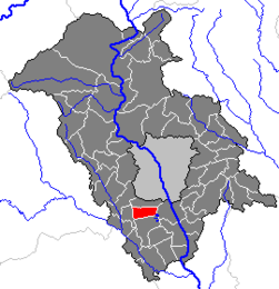 Location within Graz-Umgebung district | |
 Pirka Location within Austria | |
| Coordinates: 47°00′06″N15°23′28″E / 47.00167°N 15.39111°E | |
| Country | Austria |
| State | Styria |
| District | Graz-Umgebung |
| Area | |
• Total | 9.43 km2 (3.64 sq mi) |
| Elevation | 350 m (1,150 ft) |
| Population (2005-12-31) [1] | |
• Total | 3,286 |
| • Density | 350/km2 (900/sq mi) |
| Time zone | UTC+1 (CET) |
| • Summer (DST) | UTC+2 (CEST) |
| Postal code | 8054 |
| Area code | 0316 |
| Vehicle registration | GU |
| Website | www.pirka.steiermark.at |
Pirka is a former municipality in the district of Graz-Umgebung in the Austrian state of Styria. Since the 2015 Styria municipal structural reform, it is part of the municipality Seiersberg-Pirka. [2]