
Damanjodi is a town located in the Koraput district of Odisha, India. As of 2001 census, its population was 8,469. The town was founded as a residential area for employees of the National Aluminium Company (NALCO), a company that was established to harness the bauxite-rich deposits of the Panchpatmali Range. Damanjodi contains the NALCO Township, a residential area for NALCO employees, Mathalput, a semi-urban neighborhood with shops, and Bhejaput, a shopping complex. The population is considered cosmopolitan in nature with employees from all over India and locals from the tribal region.
Mahasamund is a city in Mahasamund District in the Indian state of Chhattisgarh.It is situated on the Mumbai-Kolkata and Raipur-Vishakhaptnam National Highways. It is one of the largest and most important cities in the State. The city is divided into 30 wards and 5 zones and is also the biggest city in the Trans-Mahanadi area. It is also the administrative headquarters of the Mahasamund District and part of the proposed new Mahasamund Municipal Corporation. The current mayor is Prakash Chandrakar. Reliance Trends, Vishal Megamart, Reliance Jio Smart Point, B mart and Zee Sale are prominent Shopping Centers of the City.
Bhandara is a city and municipal council which serves the administrative headquarters of eponymous administrative Bhandara Taluka and Bhandara district in the state of Maharashtra, India. It is connected with NH-53 and NH-247.

Memari is a town and a municipality in Purba Bardhaman district in the Indian state of West Bengal.
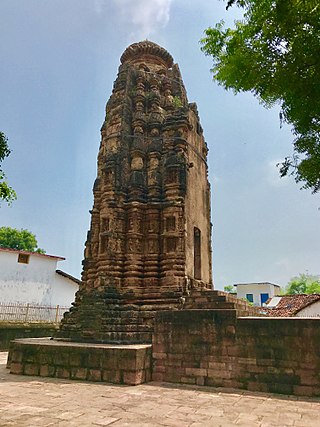
Arang, also known as "The town of temples" of Chhattisgarh, is a block and a Nagar Palika in Raipur District in the state of Chhattisgarh, India. It is situated near the eastern limits of Raipur City and close to Mahasamund City. Arang is an ancient town, which was ruled by the Haihayas Rajput dynasty. It is famous for its many Jain and Hindu temples which belong to the 11th and 12th centuries; these are the Mand Deval Jain temple, the Mahamaya temple, the Panchmukhi temple and the Hanuman temple. Due to the Archaeological finds of a copper plate inscription dated to the Gupta Empire, known as the Arang Plate of Bhimasena II of the clan of Rajarsitulya, has established the town's ancient history as a Hindu and Jain religious centre, which was then under the rule of Hindu kings. The Mand Deval Jain temple is the most ancient of these temples dated to the 11th century where three huge images of Digambara tirthankaras are deified in the sanctum sanctorum; these are carved in black stone and polished.
Bagbahara is a town and a Municipality in Mahasamund district in the state of Chhattisgarh, India. It is situated on National Highway No. 353 and Raipur-Vishakhapattanam Rail Route.
Basna is a town in Mahasamund district in the Chhattisgarh state of India.
Bhilai Charoda is a municipal corporation and a part of Bhilai city in the state of Chhattisgarh, India. Charoda is an industrial area of Bhilai city. Asia's longest railway marshaling yard is present in Charoda, Bhilai.
Kanker is a municipality and the headquarters of Kanker District, in the Indian state of Chhattisgarh. It is the second largest city of Bastar division after Jagdalpur.
Karuppur is a panchayat town in Salem District in the Indian state of Tamil Nadu. It is located on the National Highway 7 between Salem and Bangalore. The Periyar University, with which many Salem colleges are affiliated, is located here. Government College of Engineering, referred as GCE-Salem is also located here. It is a railway station on the Chennai-Shoranur railway line.
Kharupetia is a town and a municipal board in Darrang district in the Indian state of Assam. Kharupetia is a fast-developing commercial town in Mangaldoi Sub-Division under Darrang District. It is about 17 km from Mangaldoi, the District headquarters and 87 km from Guwahati, the gateway of North East region. It is connected by National Highway 15.
Kurud is a town and a nagar panchayat in Dhamtari District in the Indian state of Chhattisgarh.
Nowrozabad or Khodargama is a city and a Nagar Palika in Umaria district in the Indian state of Madhya Pradesh. Kendriya Vidyalaya Nowrozabad is situated in the G.M Complex Johilla area. Nowrozabad is the head office of Johilla area. The nearest Airport is at Jabalpur in Madhya pradesh. Nowrozabad Railway Station is on the Katni - Anuppur rail route. There are many coal mines around here. National Highway 43 has its route through Nowrozabad.
Saraipali is a town in Mahasamund district in the Indian state of Chhattisgarh. First chief minister of Madhya Pradesh, Ravishankar Shukla was elected from here.

Mahasamund district is a district in Chhattisgarh state in central India. The city of Mahasamund is the district headquarters. The district is particularly famous for the historical temple town of Sirpur besides the Mahanadi river.
Sanakarlingapuram is an industrial panchayat village in Virudhunagar district in the Indian state of Tamil Nadu.
National Highway 6 & Economic Corridor 1 (EC1), was a National Highway in India that has been separately designated under the new national highway numbering system. It was officially listed as running over 1,949 km (1,211 mi)from Surat to Kolkata. The route was also known as Asian Highway 46 (AH46) & Mumbai - Kolkata Highway and Great Eastern Highway.
Umerkote, also known as Umarkot and Amarkot, is a town of Nabarangpur district, Odisha, in eastern India. Umerkote is an urban area and the name of a Municipality declared on 3 March 2014 and a Subdivision declared by State Cabinet on 3 November 2015. The town is a prominent business place of the Nabarangpur District.
Ampani is a town in the Kalahandi district of the state of Odisha, in India. It is a gram panchayat that comes under Kokasara tehsil. It is 15 km from its main town and blocks Kokasara.

Bhilai is a city in Durg district of the Indian state of Chhattisgarh, in eastern central India. Along with its twin-city Durg, the urban agglomeration of Durg-Bhilainagar has a population of more than a million, making it the second-largest urban area in Chhattisgarh after Raipur. Bhilai is a major industrial city as well as an education hub of central India. The Bhilai metropolis contains three municipal corporations: Bhilai Municipal Corporation, Bhilai-Charoda Municipal Corporation and Risali Municipal Corporation.

