References
- ↑ "Electoral Constituencies Act 2019" (PDF). Parliament of Samoa. 31 January 2019. Retrieved 11 September 2021.
- ↑ "Census 2016 Preliminary count" (PDF). Samoa Bureau of Statistics. 2016. Retrieved 23 August 2021.
13°45′21.8″S172°19′22.61″W / 13.756056°S 172.3229472°W
Traditional center: Satupa'itea | ||
| Villages of Salega | 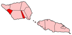 | |
| Villages of Satupa'itea | ||
| Education & Schools | ||
| Conservation & Environment | ||
| Electoral constituencies: Faipule Districts |
| |
| | This article about a geographical location in Samoa is a stub. You can help Wikipedia by expanding it. |