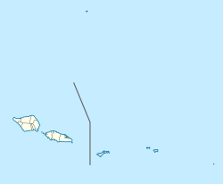
Samoa, officially the Independent State ofSamoa and until 1997 known as Western Samoa, is a Polynesian island country consisting of two main islands, two smaller, inhabited islands, and several smaller, uninhabited islands, including the Aleipata Islands. The capital city is Apia. The Lapita people discovered and settled the Samoan Islands around 3,500 years ago. They developed a Samoan language and Samoan cultural identity.

Apia is the capital of Samoa, and its only city. It is located on the central north coast of Upolu, Samoa's second-largest island. Apia falls within the political district (itūmālō) of Tuamasaga.

In the United States a county is an administrative or political subdivision of a state that consists of a geographic region with specific boundaries and usually some level of governmental authority. The term "county" is used in 48 U.S. states, while Louisiana and Alaska have functionally equivalent subdivisions called parishes and boroughs, respectively.
Samoan culture tells stories of many different deities. There were deities of the forest, the seas, rain, harvest, villages, and war. There were two types of deities, atua, who had non-human origins, and aitu, who were of human origin.

Territories of the United States are sub-national administrative divisions overseen by the United States federal government. The various U.S. territories differ from the U.S. states and Native American tribes in that they are not sovereign entities. In contrast, each state has a sovereignty separate from that of the federal government and each federally recognized Native American tribe possesses limited tribal sovereignty as a "dependent sovereign nation". Territories are classified by incorporation and whether they have an "organized" government through an organic act passed by the Congress. U.S. territories are under U.S. sovereignty and, consequently, may be treated as part of the United States proper in some ways and not others. Unincorporated territories in particular are not considered to be integral parts of the United States, and the Constitution of the United States applies only partially in those territories.

Savaiʻi is the largest and highest island both in Samoa and in the Samoan Islands chain. The island is also the sixth largest in Polynesia, behind the three main islands of New Zealand and the Hawaiian Islands of Hawaii and Maui.

Taʻū is the largest island in the Manuʻa Group and the easternmost volcanic island of the Samoan Islands. Taʻū is part of American Samoa. In the early 19th century, the island was sometimes called Opoun.

The American Samoa Fono is the territorial legislature of American Samoa. Like most state and territorial legislatures of the United States, it is a bicameral legislature with a House of Representatives and a Senate. The legislature is located in Fagatogo along Pago Pago harbor.

Aunuʻu is a small volcanic island off the southeastern shore of Tutuila in Saʻole County, American Samoa. It has a land area of 374.83 acres, and a 2010 census population of 436 persons. Politically, it is a part of the Eastern District, one of the two primary political divisions of American Samoa.

Nu'uuli is a village on the central east coast of Tutuila Island, American Samoa. It is located on a peninsula several miles up from Pago Pago International Airport. Nu’uuli is located between Pago Pago International Airport and Coconut Point. It is a shopping district which is home to stores such as South Pacific Traders, Nu’uuli Shopping Center, Aiga Supermarket and many more shops.

Tafuna is a village on the east coast of Tutuila Island, American Samoa. It is located on a mile north of Pago Pago International Airport and one mile south of Nu'uuli, American Samoa. The Ottoville district is a part of Tafuna. Near the Catholic church at Ottoville is an archeological park containing a well-preserved ancient Polynesian mound as well as a rainforest reserve. Tafuna is located on the Tafuna Plain, which is the largest flatland on the island of Tutuila.
Fagali'i or Fagali'i-uta is a village on the island of Upolu in the Samoa archipelago approximately 5 kilometres south-east of Apia. It is in the electoral constituency of Vaimauga East which forms part of the larger political district of Tuamasaga.

American Samoa is an unincorporated territory of the United States located in the South Pacific Ocean, southeast of the independent nation of Samoa. Its location is centered on 14.3°S 170.7°W. It is east of the International Date Line, while Samoa is west of the Line. The total land area is 199 square kilometers (76.8 sq mi), slightly more than Washington, D.C. American Samoa is the southernmost territory of the United States and one of two U.S. territories south of the Equator, along with the uninhabited Jarvis Island. Tuna products are the main exports, and the main trading partner is the rest of the United States.

The District of Columbia and United States Territories quarters were a series of six quarters minted by the United States Mint in 2009 to honor the District of Columbia and the unincorporated United States insular areas of Puerto Rico, Guam, the United States Virgin Islands, American Samoa, and the Northern Mariana Islands. The islands commonly grouped together as the United States Minor Outlying Islands were not featured, as the law defined the word "territory" as being limited to the areas mentioned above. They followed the completion of the 50 State Quarters Program. The coins used the same George Washington obverse as with the quarters of the previous 10 years. The reverse of the quarters featured a design selected by the Mint depicting the federal district and each territory. Unlike on the 50 State quarters, the motto "E Pluribus Unum" preceded and was the same size as the mint date on the reverse.