Related Research Articles
Gagaʻifomauga is a political district on the island of Savaiʻi in Samoa. The district is situated on the northern side of the island with a population of 4,878.

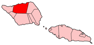
Vaisigano is a political district at the western tip of Savai'i island in Samoa. The capital of the district is Asau.
Faʻasaleleaga is a district of Samoa situated on the eastern side of Savaiʻi island. It has a population of 13,566.
Sataua is a village on the island of Savai'i in Samoa. It is situated at the northwestern end of the island in the district of Vaisigano. The population is 833.
Lalomalava is a village at the southeast end of Savai'i island in Samoa. The village is part of the electoral constituency Fa'asaleleaga I which is within the larger political district (Itumalo) of Fa'asaleleaga. The population is 307.
Apai is one of four small villages on Manono Island in Samoa. The village population is 124.
Salua is one of four small villages on Manono Island in Samoa. The village population is 136.
Afagaloa is a village on the island of Savai'i in Samoa. It is situated on the south coast of the island in the electoral constituency of Palauli West which is part of the larger political district of Palauli.
Tufutafoe is a village on the island of Savai'i in Samoa. It is situated on the west coast of the island in Vaisigano district. The village population is 434.
Papa Uta is a village on the island of Savai'i in Samoa. It is situated at the west side of the island in the political district of Vaisigano. The population is 505.
Salega is a traditional district on the island of Savai'i in Samoa. It is situated on the south side of the island. The population is 3,461.
Fuailoloo is a village on the island of Upolu in Samoa. It is situated at the north west coast of the island in the political district of Aiga-i-le-Tai.
Manono Uta is a village on the island of Upolu in Samoa. It is situated on the north west coast of the island in the political district of Aiga-i-le-Tai.
Apolima Uta is a village on the island of Upolu in Samoa. It is situated on the north west coast of the island in the political district of Aiga-i-le-Tai.

Apolima Tai is a small village settlement on the tiny volcanic island of Apolima in Samoa. The village is situated on the north side of the islet which is in the political district of Aiga-i-le-Tai.
Lepuia'i is one of four small villages on Manono Island in Samoa. The village population is 183.
Samata-i-Tai is a village on the island of Savai'i in Samoa. It is situated on the south side of the island in the traditional district (Faipule) and the electoral constituency of Salega which falls within the larger political (Itumalo) district of Satupa'itea.
Fogasavai'i is a village on the island of Savai'i in Samoa. It is situated on the south east coast of the island in the traditional district of Salega which falls within the larger political district (Itumalo) of Satupa'itea.
Vaipua is a village on the island of Savai'i in Samoa. It is situated on the south east coast of the island in the traditional district of Salega which falls within the larger political district (Itumalo) of Satupa'itea.
Fai'a'ai is a village on the island of Savai'i in Samoa. It is situated on the south east coast of the island in the traditional district of Salega which falls within the larger political district (Itumalo) of Satupa'itea. The population is 397.
References
- ↑ "Samoa Territorial Constituencies Act 1963". Pacific Islands Legal Information Institute. Archived from the original on 5 June 2011. Retrieved 15 December 2009.
- ↑ "Census 2016 Preliminary count" (PDF). Samoa Bureau of Statistics. 2016. Retrieved 23 August 2021.
Coordinates: 13°38′43.61″S172°39′46.15″W / 13.6454472°S 172.6628194°W
Traditional center: Satupa'itea | ||
| Villages of Salega |  | |
| Villages of Satupa'itea | ||
| Education & Schools | ||
| Conservation & Environment | ||
| Electoral constituencies: Faipule Districts |
| |
| | This article about a geographical location in Samoa is a stub. You can help Wikipedia by expanding it. |