Pitseng

Last updated
Pitseng
Community Council
Lesotho adm location map.svg
Red pog.svg
Pitseng
Geographic Center of Community
Coordinates: 29°00′35″S28°15′27″E / 29.00972°S 28.25750°E / -29.00972; 28.25750
CountryFlag of Lesotho.svg  Lesotho
District Leribe District
Elevation
[1]
5,505 ft (1,678 m)
Population
 (2006)
  Total18,948
Time zone UTC+2 (CAT)
Coordinates computed from Lesotho Villages file. [2]

Pitseng is a community council located in the Leribe District of Lesotho. The population in 2006 was 18,948. [3]

Contents

Villages

The community of Pitseng includes the villages of Bolahla (Ha Mahloane), Ha 'Makena, Ha 'Mamanka, Ha Botšo, Ha Filipi, Ha Jorotane, Ha Khomoatsana, Ha Khopa, Ha Lota, Ha Mahloane, Ha Majara, Ha Makape, Ha Makateng (Pitseng), Ha Makhata, Ha Miro, Ha Moepi, Ha Mofoka (Masaleng), Ha Mohatonyane, Ha Monate, Ha Mosebo, Ha Motingoe, Ha Mphasa, Ha Mphenyeke, Ha Mpshe (Ha Piletso), Ha Nchee, Ha Nkoana, Ha Ntoere (Pitseng), Ha Ntsebe, Ha Piletso (Mafaleng), Ha Rampesa, Ha Rantšala, Ha Raphoka, Ha Senyokotho, Matlameng, Ha Shekoe, Ha Tau, Ha Tefo, Ha Tjooeng, Hlokoa-Le-Monate, Khoaba-La-Eja-Bohobe, Khoabakhoaba (Pitseng), Lekhalong (Pitseng), Lilibaneng, Lipohong, Litooaneng, London (Pitseng), Phomolong, Pontšeng, Sekoaing, Tiping and Vukazenzele (Pitseng). [4]

Education

Pitseng hosted the Leadership Camp, which was sponsored by the organization Help Lesotho. Pitseng has two schools that are twinned with schools in Canada, also helped by Help Lesotho. The schools in Pitseng are Guardian Angel Primary School and Pitseng High School. They are twinned with Rockcliffe Park Public School, in Ottawa, the capital of Canada (Guardian Angel) and Gulf Islands Secondary School, in Salt Spring Island, British Columbia (Pitseng High). Guardian Angel was the first school in Lesotho to be twinned with a school in Canada. Pitseng is located in the Leribe district. It is under the chieftaincy of Chief Khethisa Tau the son of the late Chief Seoehla Khethisa Tau. There is a Roman Catholic Mission named Pontmain which is run by Sisters of Charity of Ottawa. At present there is another school on the way to Katse dam named after the Great Chief Khethisa and is called Khethisa High School, it is a well performing school under the Lesotho Evangelical Church. This school was established in 1979. When you look at the side of education, Pitseng is so advancing as it can be seen that there are other schools which are Phelisanong School for the disabled which was founded by Ms Mamello Lehlōtha Mokholokoe. this school is situated along the way to Katse Dam at Ha Makhata village just be before crossing Mphosong River. the school has recently gained support from Sentebale Funeral Gap and from Her Majesty Queen Masenate Mohato Bereng Seeso. This school does not only admit the disabled children, but it also admits children with no disability. this initiative is encouraging our children to accept and support disabled children.

Related Research Articles

Thaba-Tseka District District in Lesotho

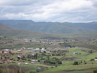
Thaba-Tseka is a district of Lesotho. Thaba-Tseka is also the name of the district's capital or camptown, which is the only town in the district. In the east, Thaba-Tseka borders on the KwaZulu-Natal Province of South Africa. Domestically, it borders on Mokhotlong District in northeast, Leribe District in north, Berea District in northwest, Maseru District in west, Mohale's Hoek District in southwest and Qacha's Nek District in the southern direction. The district is one of the major tourist attractions in Lesotho because of the second largest arch dam in Africa Katse Dam.

Leribe District District in Lesotho

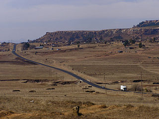
Leribè is a district of Lesotho. It has an area of 2,828 km² and a population in 2016 of approximately 337,500. Hlotse is the capital or camptown of the district. The district has one additional town, namely Maputsoe. In the west, Leribe borders on the Free State Province of South Africa. Domestically, it borders Butha-Buthe District in the north, Mokhotlong District in the east, Thaba-Tseka District in southeast and Berea District in southwest.

Katse Dam Dam in Lesotho

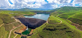
The Katse Dam, a concrete arch dam on the Malibamat'so River in Lesotho, is Africa's second largest double-curvature arch dam.. The dam is part of the Lesotho Highlands Water Project, which will eventually include five large dams in remote rural areas. The dam is just below the confluence of the Bokong River, which forms the western arm of the Katse reservoir.

Senqunyane River river in Lesotho

The Senqunyane River is a river of central Lesotho. The name means Little Orange River in Sotho. The river rises in the Maluti Mountains in northwest Lesotho, and flows southwards and then westwards for 120 kilometres before joining the Senqu River in the southwest.

Ha Lejone village in northern Lesotho

Ha Lejone is a village in the Leribe District of northern Lesotho. It is on a ridge above a bend of the Malibamat'so River, 15 kilometres (9.3 mi) east of the Mafika-Lisiu Pass, which links Ha Lejone with the community of Pitseng.

Liqhobong Community Council in Butha-Buthe District, Lesotho

Liqhobong is a community council located in the Butha-Buthe District of Lesotho. Its population in 2006 was 5,524.

Limamarela Community Council in Leribe District, Lesotho

Limamarela is a community council located in the Leribe District of Lesotho. Its population in 2006 was 8,733.

Maisa-Phoka Community Council in Leribe District, Lesotho

Maisa-Phoka is a community council located in the Leribe District of Lesotho. Its population in 2006 was 12,630.

Malaoaneng Community Council in Leribe District, Lesotho

Malaoaneng is a community council located in the Leribe District of Lesotho. Its population in 2006 was 5,864.

Matlameng Community Council in Leribe District, Lesotho

Matlameng is a community council located in the Leribe District of Lesotho. Its population in 2006 was 10,238.

Menkhoaneng Community Council in Leribe District, Lesotho

Menkhoaneng is a community council located in the Leribe District of Lesotho. Its population in 2006 was 22,502.

Motati Community Council in Leribe District, Lesotho

Motati is a community council located in the Leribe District of Lesotho. Its population in 2006 was 10,080.

Mphorosane Community Council in Leribe District, Lesotho

Mphorosane is a community council located in the Leribe District of Lesotho. Its population in 2006 was 9,392.

Serupane Community Council in Leribe District, Lesotho

Serupane is a community council located in the Leribe District of Lesotho. Its population in 2006 was 11,328.

Tsoilitsoili Community Council in Leribe District, Lesotho

Tsoilitsoili is a community council located in the Leribe District of Lesotho. Its population in 2006 was 18,456.

Malakeng Community Council in Mafeteng District, Lesotho

'Malakeng is a community council located in the Mafeteng District of Lesotho. Its population in 2006 was 8,382.

Matsoku Community Council in Mokhotlong District, Lesotho

Matsoku is a community council located in the Mokhotlong District of Lesotho. Its population in 2006 was 4,715.

Thaba-Chitja Community Council in Thaba-Tseka District, Lesotho

Bokong is a community council located in the Thaba-Tseka District of Lesotho. Its population in 2006 was 7,283.

Makheka, Thaba-Tseka District Community Council in Thaba-Tseka District, Lesotho

Rapoleboea is a community council located in the Thaba-Tseka District of Lesotho. Its population in 2006 was 11,533.

Ratšoleli Community Council in Qachas Nek District, Lesotho

Ratšoleli is a community council located in the Qacha's Nek District of Lesotho. Its population in 2006 was 6,633.

References

  1. GTOPO30 via GeoNames. Retrieved 2010-08-23.
  2. Google Earth Download Site Retrieved 2010-07-21.
  3. Lesotho Bureau of Statistics, 2006, Census Pre Results
  4. Lesotho Bureau of Statistics, Village List, 2006.