
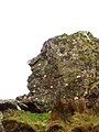
Pitt's Head (Welsh: Carreg Collwyn) is a distinctive rock located at grid reference SH576515 , close to the A4085 road in Gwynedd, Wales. Its distinction lies in a resemblance to the profile of politician William Pitt the Younger.
Pitt's Head (Welsh: Carreg Collwyn) is a distinctive rock located at grid reference SH576515 , close to the A4085 road in Gwynedd, Wales. Its distinction lies in a resemblance to the profile of politician William Pitt the Younger.
Located as it is near the base of one of the paths to the summit of Snowdon, Pitt's Head Halt was a station on the original Welsh Highland Railway, also marking the highest point on that railway. The present reconstruction of the railway does not envisage reopening the halt. The rock gives its name to the Pitt's Head Bridge, where the railway passes under the A4085, and the nearby Pitt's Head Cutting.
In the geology of the region, the rock gives its name to the rock of which it is formed, the Pitt's Head Tuff. This is an Ordovician acid ash-flow tuff which outcrops on the northern flanks of Snowdonia.
The correct name for this rock cluster is Cerrig Collwyn, Pitt's Head is only a name for one of these rocks. Collwyn ap Tango was said to be Lord of Eifionnydd, Ardudwy and part of Llŷn.


Snowdonia or Eryri, is a mountainous region in northwestern Wales and a national park of 823 square miles (2,130 km2) in area. It was the first to be designated of the three national parks in Wales, in 1951.

Beddgelert is a village and community in the Snowdonia area of Gwynedd, Wales. The population of the community taken at the 2011 census was 455, and includes Nantmor and Nant Gwynant. It is reputed to be named after the legendary hound Gelert. The community is large and sparsely populated and covers 86 square kilometres.

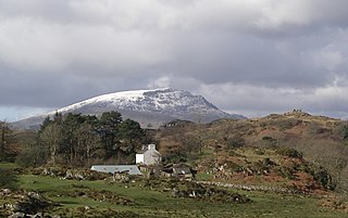
Snowdon or Yr Wyddfa, is the highest mountain in Wales, at an elevation of 1,085 metres (3,560 ft) above sea level, and the highest point in the British Isles outside the Scottish Highlands. It is located in Snowdonia National Park in Gwynedd.

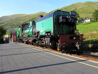
The Welsh Highland Railway (WHR) or Rheilffordd Eryri is a 25-mile (40.2 km) long, restored 1 ft 11+1⁄2 in narrow gauge heritage railway in the Welsh county of Gwynedd, operating from Caernarfon to Porthmadog, and passing through a number of popular tourist destinations including Beddgelert and the Aberglaslyn Pass. At Porthmadog it connects with the Ffestiniog Railway and to the short Welsh Highland Heritage Railway. In Porthmadog it uses the United Kingdom's only mixed gauge flat rail crossing.

Colwyn Bay is a town, community and seaside resort in Conwy County Borough on the north coast of Wales overlooking the Irish Sea. It lies within the historic county of Denbighshire. Eight neighbouring communities are incorporated within its postal district. Established as its own separate parish in 1844 with just a small grouping of homes and farms where the community of Old Colwyn stands today, Colwyn Bay has expanded to become the second-largest community and business centre in the north of Wales as well as the 14th largest in the whole of Wales with the urban statistical area, including Old Colwyn, Rhos-on-Sea, and Mochdre and Penrhyn Bay, having a population of 34,284 at the 2011 census.
The National Three Peaks Challenge is an event in which participants attempt to climb the highest mountains of England, Scotland and Wales within 24 hours. It is frequently used to raise money for charitable organisations. Walkers climb each peak in turn, and are driven from the foot of one mountain to the next. The three peaks are:
Llangrannog is both a village and a community in Ceredigion, Wales, 6 miles (10 km) southwest of New Quay. It lies in the narrow valley of the River Hawen, which falls as a waterfall near the middle of the village. Llangrannog is on the Wales Coast Path.

The North Wales Narrow Gauge Railways (NWNGR) was a railway company that planned to build a number of inter-connected 1 ft 11+1⁄2 in narrow-gauge railways across North Wales. The first two of these lines - jointly known as the "Moel Tryfan Undertaking" - were authorised by Act of Parliament 1872 and were built and opened in the 1870s. The original main line ran from Dinas Junction to Bryngwyn and opened in 1877. The second line was a branch from Tryfan Junction to South Snowdon, though shortly after opening, the company designated the Tryfan Junction to Bryngwyn section as the branch, and the Dinas Junction to South Snowdon section as the main line.

The Bishops and Clerks are a group of rocks and islets, approximately 1+1⁄2 miles (2.4 km) west of Ramsey Island, Pembrokeshire, Wales.
Waunfawr is a village and community, 6 kilometres (3.7 mi) SE of Caernarfon, near the Snowdonia National Park, Gwynedd, in Wales.

Russell is a narrow gauge steam locomotive originally built in 1906 for the North Wales Narrow Gauge Railways (NWNGR), but most famously associated with the original Welsh Highland Railway (WHR), and now based at the Welsh Highland Heritage Railway in Porthmadog.

Llyn Cwellyn is a reservoir in North Wales which supplies drinking water to parts of Gwynedd and Anglesey. It lies on the Afon Gwyrfai in Nant y Betws between Moel Eilio and Mynydd Mawr in the northern part of Snowdonia National Park. It has an area of 215 acres (0.87 km2), and is over 120 ft (37 m) deep. At the southern end is the small village of Rhyd Ddu.

Rhyd Ddu is a station on the narrow gauge Welsh Highland Railway, which was built in 1881 as the North Wales Narrow Gauge Railways Moel Tryfan Undertaking to carry dressed slate to Dinas Junction on the LNWR. It has also previously been named both "Snowdon" and "South Snowdon".
Snowdon Ranger is a station on the narrow gauge Welsh Highland Railway, which was built in 1878 as the North Wales Narrow Gauge Railways Moel Tryfan Undertaking, to carry dressed slate to Dinas Junction on the LNWR. The station was originally known as Quellyn Lake but was renamed after the path to the Summit of Snowdon popularised by, and named after, the local mountain guide, "The Snowdon Ranger", who went by that name for many years. Certainly the name "Snowdon Ranger" was in common use on company timetables from as early as 1879, and that of the adjacent Snowdon Ranger Hotel from at least 1869.

Llyn Cowlyd is the deepest lake in northern Wales. It lies in the Snowdonia National Park at the upper end of Cwm Cowlyd on the south-eastern edge of the Carneddau range of mountains, at a height of 1,164 feet (355 m) above sea level. The lake is long and narrow, measuring nearly 2 miles (3 km) long and about a third of a mile wide, and covers an area of 269 acres (1.1 km2). It has a mean depth of 109 feet (33 m) and at its deepest has given soundings of 229 feet (70 m), this being some 45 ft (14 m) greater than its natural depth, the water surface having been raised twice by the building of dams.
River Adda is a small watercourse which flows, through the city of Bangor North Wales before discharging into the Menai Strait at Hirael Bay, opposite Porth Penrhyn. The name is said to be of 19th-century origin, deriving from a field Cae Mab Adda close to its source. Its earlier name was Tarannon.

The A498 is a 16-mile road between Pen-y-Gwryd and Porthmadog in North Wales.
The A4085 is a 20-mile road between Caernarfon and Penrhyndeudraeth in North Wales that runs through the scenic Aberglaslyn Pass. There are several locations where the road is of substandard width.

Afon Meillionen is a small river near Beddgelert in Gwynedd, north-west Wales.
Yr Arddu is a large hill in Snowdonia, Wales. It lies approximately 2.5 km south east of the village of Beddgelert and just over 1 km from the rather more famous mountain Cnicht. It is a rugged hill with widespread rock outcrops and cliffs. A small lake, Llyn yr Arddu, is located on the flanks of the mountain. The recognised summit is at 388m to the South of the hill, but the highest point, named Cerrig-y-Myllt on only the most detailed UK Ordnance Survey mapping, is at 463m above the two small lakes to the North of the hill. The craggy nature of the hill is due to the presence of lavas and tuffs dating from the Ordovician period when Snowdonia was characterised by numerous volcanic eruptions; Yr Arddu is a particularly good location to see the record of Ordovician volcanism. The Yr Arddu Tuffs may be the earliest eruptive phase of the Lower Rhyolitic Tuff Formation.