
Tyrol is an Austrian federal state. It comprises the Austrian part of the historical Princely County of Tyrol. It is a constituent part of the present-day Euroregion Tyrol–South Tyrol–Trentino. The capital of Tyrol is Innsbruck.

The Inn is a river in Switzerland, Austria and Germany. The 518 km (322 mi) long river is a right tributary of the Danube, being the third largest tributary of the Danube by discharge. The highest point of its drainage basin is the summit of Piz Bernina at 4,049 m (13,284 ft). The Engadine, the valley of the En, is the only Swiss valley whose waters end up in the Black Sea.

The Sill is a 43-kilometre-long (27 mi) river in Tyrol, Austria. It is one of the larger tributaries of the Inn, joining it from the right bank in Tyrol. It flows north through the Wipptal to Innsbruck. Its source lies east of the Brenner Pass. At the Sillzwickel - the name of the point where it meets the Inn at Innsbruck - there is a recreation area with cycling trails.

Imst is a town in the Austrian federal state of Tyrol. It lies on the River Inn in western Tyrol, some 50 kilometres west of Innsbruck and at an altitude of 828 metres above sea level. With a current population (2018) of 10,504, Imst is the administrative centre of Imst District.
The Bezirk Imst is an administrative district (Bezirk) in Tyrol, Austria. It borders the district Reutte in the north, as well as sharing a small border with Bavaria (Germany). It borders the district Innsbruck-Land in the east, South Tyrol (Italy) in the south, and the district Landeck in the west.

Arzl im Pitztal is a municipality and a town in the district of Imst in the Austrian state of Tyrol.
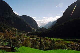
The Ötztal is an alpine valley located in Tyrol, Austria. The Ötztaler Ache river flows through the valley in a northern direction. The Ötztal separates the Stubai Alps in the east from the Ötztal Alps in the west. The valley is 65 km (40 mi) long. The northern end of the valley is at the confluence of the Ötztaler Ache and Inn rivers, 8 km east of Imst and 50 km west of Innsbruck. The only railway station of the valley, Ötztal railway station, is located here and connects the Ötztal with the Arlberg railway (Innsbruck-Bludenz) and also a motorway interchange to the A12 (E60).
The Via Claudia Augusta is an ancient Roman road, which linked the valley of the Po River with Rhaetia across the Alps.

The Gurglbach is a river of Tyrol, Austria.

The Lohbach is a river of Tyrol, Austria, in the municipal area of Innsbruck, a tributary of the Inn.

Pfafflar is a municipality in the district of Reutte in the Austrian state of Tyrol.

Jerzens is a municipality and a village in the district of Imst (district) and is located 8 km south of Imst at the Pitze River in the valley with the same name. Settlement of the area began around 600. The village was mentioned in a register in 1313 for the first time. Jerzens has 1008 inhabitants and its main source of income is agriculture and tourism.

Wenns is a municipality in the Imst district 7.30 km south of Imst at the Pitze river. Due to its central location in the Pitztal valley it is one of the area's key villages. The primary source of income is tourism, especially skiing even though there is no skiing in Wenns itself. The 700-year-old Stamserhaus in Wenns is the oldest farmhouse in Tyrol.

Stams is a municipality in Imst District, in the Austrian state of Tyrol. It is chiefly known for Cistercian Stams Abbey, founded in 1273 by Count Meinhard II of Gorizia-Tyrol and his wife.

Sankt Leonhard im Pitztal is a municipality in the Imst district, located 20 kilometres (12 mi) south of Imst on the upper course of the Pitze River in western Austria. The village covers a large area and has a length of around 25 kilometres (16 mi). It is one of the biggest communities of Tyrol by area.

Silz is a municipality in Austria in the Imst district. It is located 15 kilometres (9.3 mi) east of Imst and 11 kilometres (6.8 mi) west of Telfs. The ski resort Kühtai administratively belongs to the village area. Besides winter tourism, summer tourism, especially rafting on the Inn River, is also an important source of income for Silz.

The Ötztaler Ache is a river in the district of Imst, Tyrol state of Austria. It is a right tributary of the Inn. It flows through the Ötztal valley, a southern branch the Inntal. Including its source rivers Venter Ache and Rofenache, it is 66.5 kilometres (41.3 mi) long. The Rofenache is the runoff of the Hintereisferner, a glacier at the foot of the Weißkugel, Ötztal Alps. At Vent, near Sölden, it takes up the Niedertalbach and its name changes to Venter Ache. At the confluence with the Gurgler Ache in Zwieselstein, Sölden, the Ötztaler Ache proper is formed. It flows through Sölden, Längenfeld, Umhausen and Oetz before joining the Inn 8 kilometres (5.0 mi) east of Imst. The river is one of its bigger tributaries.
The Sanna is a river of Tyrol, Austria, a left tributary of the Inn.

The Tyrolean Oberland is that part of the Austrian state of Tyrol west of Innsbruck or, more precisely, west of the Melach river, but excluding the Außerfern region.
