Arzl im Pitztal

Last updated
Arzl im Pitztal
Arzl im Pitztal.jpg
Arzl im Pitztal
AUT Arzl im Pitztal COA.svg
Arzl im Pitztal im Bezirk IM.png
Location in the district
Austria adm location map.svg
Red pog.svg
Arzl im Pitztal
Location within Austria
Austria Tyrol location map.svg
Red pog.svg
Arzl im Pitztal
Arzl im Pitztal (Tyrol, Austria)
Coordinates: 47°12′30″N10°45′45″E / 47.20833°N 10.76250°E / 47.20833; 10.76250
Country Austria
State Tyrol
District Imst
Government
   Mayor Josef Knabl (Bürgermeisterliste)
Area
[1]
  Total29.37 km2 (11.34 sq mi)
Elevation
880 m (2,890 ft)
Population
 (2018-01-01) [2]
  Total3,134
  Density110/km2 (280/sq mi)
Time zone UTC+1 (CET)
  Summer (DST) UTC+2 (CEST)
Postal code
6471
Area code 05412
Vehicle registration IM
Website www.arzl-pitztal.tirol.gv.at

Arzl im Pitztal is a municipality and a town [3] in the district of Imst in the Austrian state of Tyrol.

Contents

Geography

The stream Pitze flows through the municipality.

Population

Historical population
YearPop.±%
18691,425    
18801,395−2.1%
18901,307−6.3%
19001,241−5.0%
19101,243+0.2%
19231,247+0.3%
19341,353+8.5%
19391,380+2.0%
19511,604+16.2%
YearPop.±%
19611,802+12.3%
19712,111+17.1%
19812,316+9.7%
19912,530+9.2%
20012,783+10.0%
20112,969+6.7%
20163,042+2.5%
20173,088+1.5%

Personalities

The professional skier Benjamin Raich and the band Mother's Cake come from the village.

Related Research Articles

Leopoldsdorf im Marchfeld is a town in the district of Gänserndorf in the Austrian state of Lower Austria.

Leogang is a municipality in the district of Zell am See, in the state of Salzburg in Austria. It is a famous winter sports and summer mountain hiking resort.

<span class="mw-page-title-main">Oberhofen im Inntal</span> Place in Tyrol, Austria

Oberhofen im Inntal is a municipality in the western district of Innsbruck-Land in the Austrian state of Tyrol located 21 km west of Innsbruck and 2.6 km east of Telfs. Once a part of Pfaffenhofen it became its own municipality in 1786.

<span class="mw-page-title-main">Wenns</span> Place in Tyrol, Austria

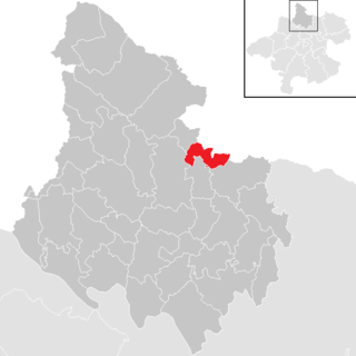
Wenns is a municipality in the Imst district 7.30 km south of Imst at the Pitze river. Due to its central location in the Pitztal valley it is one of the area's key villages. The primary source of income is tourism, especially skiing even though there is no skiing in Wenns itself. The 700-year-old Stamserhaus in Wenns is the oldest farmhouse in Tyrol.

<span class="mw-page-title-main">Sankt Leonhard im Pitztal</span> Place in Tyrol, Austria

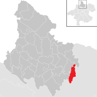
Sankt Leonhard im Pitztal is a municipality in the Imst district, located 20 kilometres (12 mi) south of Imst on the upper course of the Pitze River in western Austria. The village covers a large area and has a length of around 25 kilometres (16 mi). It is one of the biggest communities of Tyrol by area.

<span class="mw-page-title-main">Weng im Innkreis</span> Place in Upper Austria, Austria

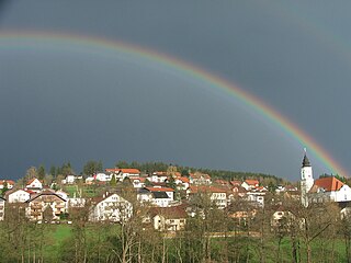
Weng im Innkreis is a municipality in the district of Braunau am Inn in the Austrian state of Upper Austria.

<span class="mw-page-title-main">Rainbach im Mühlkreis</span> Place in Upper Austria, Austria

Rainbach im Mühlkreis is a municipality in the district of Freistadt in the Austrian state of Upper Austria.

<span class="mw-page-title-main">Neumarkt im Hausruckkreis</span> Place in Upper Austria, Austria

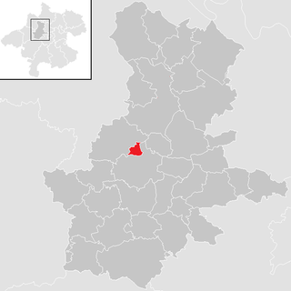
Neumarkt im Hausruckkreis is a municipality in the district of Grieskirchen in the Austrian state of Upper Austria.

<span class="mw-page-title-main">Allerheiligen im Mühlkreis</span> Place in Upper Austria, Austria

Allerheiligen im Mühlkreis is a municipality in the district of Perg in the Austrian state of Upper Austria. It is not to be confused with the Styrian municipality of Allerheiligen bei Wildon.

<span class="mw-page-title-main">Ort im Innkreis</span> Place in Upper Austria, Austria

Ort im Innkreis is a municipality in the district of Ried im Innkreis in the Austrian state of Upper Austria.

<span class="mw-page-title-main">Hofkirchen im Mühlkreis</span> Place in Upper Austria, Austria

Hofkirchen im Mühlkreis is a municipality in the district of Rohrbach in the Austrian state of Upper Austria.

<span class="mw-page-title-main">Sankt Veit im Mühlkreis</span> Place in Upper Austria, Austria

Sankt Veit im Mühlkreis is a municipality in the district of Rohrbach in the Austrian state of Upper Austria.

<span class="mw-page-title-main">Sankt Ulrich im Mühlkreis</span> Place in Upper Austria, Austria

Sankt Ulrich im Mühlkreis is a municipality in the district of Rohrbach in the Austrian state of Upper Austria.

<span class="mw-page-title-main">Sankt Martin im Mühlkreis</span> Place in Upper Austria, Austria

Sankt Martin im Mühlkreis is a municipality in the district of Rohrbach in the Austrian state of Upper Austria.

<span class="mw-page-title-main">Pfarrkirchen im Mühlkreis</span> Place in Upper Austria, Austria

Pfarrkirchen im Mühlkreis is a municipality in the district of Rohrbach in the Austrian state of Upper Austria.

<span class="mw-page-title-main">Lichtenau im Mühlkreis</span> Place in Upper Austria, Austria

Lichtenau im Mühlkreis is a municipality in the district of Rohrbach in the Austrian state of Upper Austria.

<span class="mw-page-title-main">Kopfing im Innkreis</span> Place in Upper Austria, Austria

Kopfing im Innkreis is a municipality in the district of Schärding in the Austrian state of Upper Austria.

<span class="mw-page-title-main">Berg im Attergau</span> Place in Upper Austria, Austria

Berg im Attergau is a municipality in the district of Vöcklabruck in the Austrian state of Upper Austria.

<span class="mw-page-title-main">St Georgen im Attergau</span> Place in Upper Austria, Austria

Sankt Georgen im Attergau is a municipality in the district of Vöcklabruck in the Austrian state of Upper Austria.

<span class="mw-page-title-main">Weißenkirchen im Attergau</span> Place in Upper Austria, Austria

Weißenkirchen im Attergau is a municipality in the district of Vöcklabruck in the Austrian state of Upper Austria.

References

  1. "Dauersiedlungsraum der Gemeinden Politischen Bezirke und Bundesländer - Gebietsstand 1.1.2018". Statistics Austria. Retrieved 10 March 2019.
  2. "Einwohnerzahl 1.1.2018 nach Gemeinden mit Status, Gebietsstand 1.1.2018". Statistics Austria. Retrieved 9 March 2019.
  3. Haufendorf