
The Dominican Republic is a country in the West Indies that occupies the eastern five-eighths of Hispaniola. It has an area of 48,670 km2, including offshore islands. The land border shared with Haiti, which occupies the western three-eighths of the island, is 376 km long. The maximum length, east to west, is 390 km from Punta de Agua to Las Lajas, on the border with Haiti. The maximum width, north to south, is 265 km from Cape Isabela to Cape Beata. The capital, Santo Domingo, is located on the south coast.

The Republic of Haiti comprises the western three-eighths of the island of Hispaniola, west of the Dominican Republic. Haiti is positioned east of the neighboring island of Cuba, between the Caribbean Sea and the North Atlantic Ocean. Haiti's geographic coordinates are at a longitude of 72° 25′ west and a latitude of 19° 00′ north.

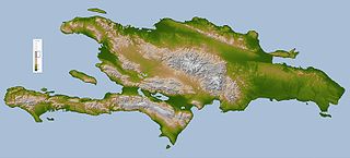
Hispaniola is an island in the Caribbean that is part of the Greater Antilles. Hispaniola is the most populous island in the West Indies, and the region's second largest in area, after the island of Cuba.

Ouest (French) or Lwès is one of the ten departments of Haiti and located in Centre-Sud of the country linking the Great-North and the Tiburon Peninsula.

Nord (French) or Nò is one of the ten departments of Haiti and located in northern Haiti. It has an area of 2,114.91 km2 (816.57 sq mi) and a population of 1,067,177 (2015). Its capital is Cap-Haïtien.

Étang Saumâtre is the largest lake in Haiti and the second largest lake in the Dominican Republic and Hispaniola, after Lake Enriquillo. It is also known as Lake Azuéi ; its Taíno name was Yainagua.

Lake Enriquillo is a hypersaline lake in the Dominican Republic located in the southwestern region of the country. Its waters are shared between the provinces of Bahoruco and Independencia, the latter of which borders Haiti. Lake Enriquillo is the largest lake in both the Dominican Republic and Hispaniola, as well as the entire Caribbean. It is also the lowest point for an island country.

The Artibonite River is the longest river in Haiti, and the longest on the island of Hispaniola. It is also the second-longest river in the Caribbean, behind the Cauto River in Cuba. Forming part of the international border between Haiti and the Dominican Republic, the river's sources are in the Cordillera Central in the Dominican Republic (68 km); however, most of its length lies in Haiti (253 km).
Trou Caïman, sometimes called Eau Gallée by locals, is a saltwater lake in Haiti known for its excellent birdwatching opportunities.
Duvergé, also known locally as Las Damas is the largest city in the province of Independencia in the Dominican Republic. The first settlers of this community were the gentlemen Christopher Pérez and María del Pulgar, originating from San Juan de la Maguana.
The 1770 Port-au-Prince earthquake took place at 7:15 pm local time on June 3, on the Enriquillo fault near Port-au-Prince, Saint-Domingue, the French colony that is now the country of Haiti.

There are currently no functioning railways in Haiti, and there have never been any rail connections with the neighbouring Dominican Republic. However, between 1876 and the 1970s, various tramways and railways ran in the country. A tram network operated in the capital, Port-au-Prince, between 1897 and 1932. Three railway lines, along with some industrial lines, constituted the Haitian national rail network. The first horse drawn street tramway opened in 1876, with rural railways constructed later.
Rivière Blanche is a river in Haiti in the Ouest department. Downstream, one arm is channeled towards the Étang Saumâtre, another joined the Canal Boucanbrou and the Trou Caïman.
The Massif du Nord is the longest mountain range of Haiti.

The Sierra de Bahoruco National Park is an environmentally protected national park located in the South-western region of Dominican Republic. It was created in 1983 by Presidential Decree during the presidency of Salvador Jorge Blanco.

The Dominican Republic–Haiti border is an international border between the Dominican Republic and the Republic of Haiti on the island of Hispaniola. Extending from the Caribbean Sea in the south to the Atlantic Ocean in the north, the 391 km border was agreed upon in the 1929 Dominican-Haitian border treaty.

The Hispaniolan dry forests are a tropical dry broadleaf forest ecoregion on the island of Hispaniola. They cover 15,123 km2 (5,839 sq mi), around 20% of the island's area.

The Enriquillo wetlands are a flooded grasslands and savannas ecoregion on the island of Hispaniola. They cover about 628 km2 (242 sq mi) around several low-lying lakes in southwestern Hispaniola in both the Dominican Republic and Haiti.
