
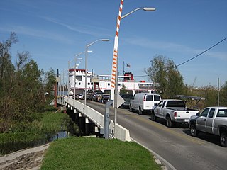
The Plaquemine Ferry is a ferry across the Mississippi River in the U.S. state of Louisiana, connecting Plaquemine and Sunshine. [1] [2] The ferry has a current capacity of 35 standard vehicles and operates on the half hour schedule.
The Plaquemine Ferry is a ferry across the Mississippi River in the U.S. state of Louisiana, connecting Plaquemine and Sunshine. [1] [2] The ferry has a current capacity of 35 standard vehicles and operates on the half hour schedule.
Plaquemines Parish is a parish located in the U.S. state of Louisiana. With a population of 23,515 at the 2020 census, the parish seat is Pointe à la Hache and the largest community is Belle Chasse. The parish was formed in 1807.

Plaquemine is a city in and the parish seat of Iberville Parish, Louisiana, United States. It is part of the Baton Rouge metropolitan statistical area. At the 2010 United States census, the population was 7,119; the 2020 census determined its population was 6,269.

Buras-Triumph is an unincorporated community in Plaquemines Parish, Louisiana, United States. The population was 3,358 at the 2000 census. For the 2010 census, Buras-Triumph was split into the CDPs of Buras and Triumph. On the peninsula, Buras has been located higher, with Triumph located southeast of Buras.

Port Sulphur is a census-designated place (CDP) on the West Bank of the Mississippi River in Plaquemines Parish, Louisiana, United States; at the 2020 census, it had a population of 1,677.

Venice is an unincorporated community and census-designated place in Plaquemines Parish, Louisiana, United States. As of the 2020 census, its population was 162. It is 77 miles (124 km) south of New Orleans on the west bank of the Mississippi River at 29°16′37″N89°21′17″W. It is the last community down the Mississippi accessible by automobile, and it is the southern terminus of the Great River Road. This has earned the town the nickname "The end of the world." The ZIP code for Venice is 70091.
Pointe à la Hache is a census-designated place (CDP) and unincorporated community in Plaquemines Parish, Louisiana, United States. Located on the east bank of the Mississippi River, the village has been the seat for Plaquemines Parish since the formation of the parish. As of the 2010 census, its population was 187, less than half its 1930 population. It suffered severe damage from Hurricane Katrina in 2005 and Tropical Storm Lee in 2011.
The Taensa were a Native American people whose settlements at the time of European contact in the late 17th century were located in present-day Tensas Parish, Louisiana. The meaning of the name, which has the further spelling variants of Taenso, Tinsas, Tenza or Tinza, Tahensa or Takensa, and Tenisaw, is unknown. It is believed to be an autonym. The Taensa should not be confused with the Avoyel, known by the French as the petits Taensas, who were mentioned in writings by explorer Pierre Le Moyne d'Iberville in 1699. The Taensa are more closely related to the Natchez people and both are considered descendants of the late prehistoric Plaquemine culture.
The New Roads–St. Francisville Ferry was a ferry service that connected Louisiana Highway 10 across the Mississippi River between New Roads and St. Francisville, Louisiana, United States. The normal operating hours for the 35-car ferry were 5 am to 9 pm, daily.
The Chalmette–Lower Algiers Ferry is a ferry across the Mississippi River in the U.S. state of Louisiana, connecting Chalmette and Algiers.

The Angola Ferry was a small and little-known ferry service that crossed the Mississippi River connecting Lettsworth, Louisiana with the Louisiana State Penitentiary, otherwise known as the Angola Prison. It was considered difficult to access, requiring drivers to branch off the Louisiana Highway 418 on an unmarked gravel road and traveling several hundred yards thereafter. A good portion of the area's population was unaware of its existence because it serves mainly prison personnel traveling to and from work.
The Edgard–Reserve Ferry was a ferry across the Mississippi River in the U.S. state of Louisiana, connecting Edgard and Reserve. The ferry was one of three routes then operated by the Louisiana Department of Highways, District 2. The others were the vehicle Luling–Destrehan Ferry and the pedestrian Taft–Norco Ferry. The ferry ceased operation on July 31, 2013.

The Belle Chasse–Scarsdale Ferry is a ferry across the Mississippi River in the U.S. state of Louisiana, connecting Belle Chasse and Scarsdale and is maintained by Plaquemines Parish. It carries a $1 toll for 2-axle vehicles, $2 for vehicles with at least 3 axles, and $.50 for motorcycles. The eastbank ferry leaves every 15 and 45 minutes on the hour between 5:15 AM and 12:15 AM; the westbank ferry leaves on the top and bottom of every hour between 5 AM and Midnight.

The Pointe à la Hache Ferry or Pointe a la Hache Ferry, is a ferry across the Mississippi River in the U.S. state of Louisiana, connecting West Pointe à la Hache and Pointe à la Hache in Plaquemines Parish, Louisiana. Currently, it is $1 for single or double axle vehicles, three or more axles are $2. It is the last vehicle crossing of the river in the down river direction. The East Bank side of the ferry is near the end of paved roadway; on the West Bank the river road continues down to Venice, Louisiana. As the eastbank of Plaquemines Parish has little population in the aftermath of Hurricane Katrina, ferry service to the eastbank occurs at the top of every hour between 6 AM and 10 PM, as well as at 6:30 AM. Likewise, ferry service to the westbank occurs at 6:15 AM, 6:45 AM, and on the bottom of every hour between 7:30 AM and 10:30 PM.
West Pointe à la Hache is an unincorporated community in Plaquemines Parish, Louisiana, United States.

The Plaquemine culture was an archaeological culture centered on the Lower Mississippi River valley. It had a deep history in the area stretching back through the earlier Coles Creek and Troyville cultures to the Marksville culture. The Natchez and related Taensa peoples were their historic period descendants. The type site for the culture is the Medora Site in Louisiana; while other examples include the Anna, Emerald, Holly Bluff, and Winterville sites in Mississippi.

Davant is an unincorporated community located in the delta of the Mississippi River in the parish of Plaquemines, Louisiana, United States.
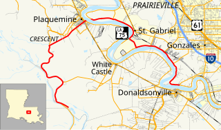
Louisiana Highway 75 (LA 75) is a state highway located in southeastern Louisiana. It runs 46.86 miles (75.41 km) in a general east–west direction from a dead end in Bayou Pigeon to the junction of LA 22 and LA 942 in Darrow.
The Luling–Destrehan Ferry was a ferry across the Mississippi River in the U.S. state of Louisiana, connecting Luling and Destrehan. The ferry was one of three routes then operated by the Louisiana Department of Highways, District 2. The others were the pedestrian Taft–Norco Ferry and the vehicle Edgard–Reserve Ferry. The ferry ceased operation in October 1983 with the opening of the Luling-Destrehan Bridge.
The Taft–Norco Ferry was a pedestrian ferry across the Mississippi River in the U.S. state of Louisiana, connecting Taft and Norco. The ferry was one of three routes then operated by the Louisiana Department of Highways, District 2. The others were the vehicle Luling–Destrehan Ferry and the vehicle Edgard–Reserve Ferry.
Mathematics, Science, and Arts Academy - West or MSA West is a public K-12 school in unincorporated Iberville Parish, Louisiana, near Plaquemine. It is a part of the Iberville Parish School Board and serves the portion of the parish on the west bank of the Mississippi River, which is the more populated section.
Crossings of the Mississippi River | ||||
|---|---|---|---|---|
| ||||
Coordinates: 30°17′02″N91°12′58″W / 30.284°N 91.216°W
| | This article about transportation in Louisiana is a stub. You can help Wikipedia by expanding it. |
| | This ferry article is a stub. You can help Wikipedia by expanding it. |