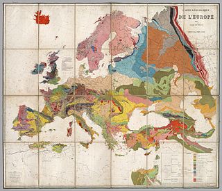
An orogeny is an event that leads to both structural deformation and compositional differentiation of the Earth's lithosphere at convergent plate margins. An orogen or orogenic belt develops when a continental plate crumples and is pushed upwards to form one or more mountain ranges; this involves a series of geological processes collectively called orogenesis.
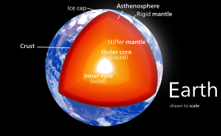
In geology, the crust is the outermost solid shell of a rocky planet, dwarf planet, or natural satellite. It is usually distinguished from the underlying mantle by its chemical makeup; however, in the case of icy satellites, it may be distinguished based on its phase.
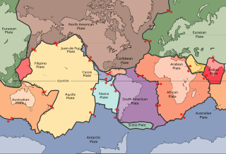
A lithosphere is the rigid, outermost shell of a terrestrial-type planet, or natural satellite, that is defined by its rigid mechanical properties. On Earth, it is composed of the crust and the portion of the upper mantle that behaves elastically on time scales of thousands of years or greater. The outermost shell of a rocky planet, the crust, is defined on the basis of its chemistry and mineralogy.

A craton is an old and stable part of the continental lithosphere, which consists of the Earth's two topmost layers, the crust and the uppermost mantle. Having often survived cycles of merging and rifting of continents, cratons are generally found in the interiors of tectonic plates. They are characteristically composed of ancient crystalline basement rock, which may be covered by younger sedimentary rock. They have a thick crust and deep lithospheric roots that extend as much as several hundred kilometres into the Earth's mantle.

Continental crust is the layer of igneous, sedimentary, and metamorphic rocks that forms the continents and the areas of shallow seabed close to their shores, known as continental shelves. This layer is sometimes called sial because its bulk composition is richer in silicates and aluminium minerals and has a lower density compared to the oceanic crust, called sima which is richer in magnesium silicate minerals and is denser. Changes in seismic wave velocities have shown that at a certain depth, there is a reasonably sharp contrast between the more felsic upper continental crust and the lower continental crust, which is more mafic in character.

Mountain formation refers to the geological processes that underlie the formation of mountains. These processes are associated with large-scale movements of the Earth's crust. Folding, faulting, volcanic activity, igneous intrusion and metamorphism can all be parts of the orogenic process of mountain building. The formation of mountains is not necessarily related to the geological structures found on it.

A large igneous province (LIP) is an extremely large accumulation of igneous rocks, including intrusive and extrusive, arising when magma travels through the crust towards the surface. The formation of LIPs is variously attributed to mantle plumes or to processes associated with divergent plate tectonics. The formation of some of the LIPs the past 500 million years coincide in time with mass extinctions and rapid climatic changes, which has led to numerous hypotheses about the causal relationships. LIPs are fundamentally different from any other currently active volcanoes or volcanic systems.
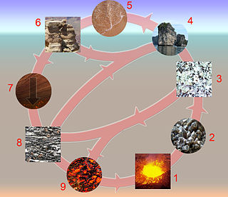
The rock cycle is a basic concept in geology that describes transitions through geologic time among the three main rock types: sedimentary, metamorphic, and igneous. Each rock type is altered when it is forced out of its equilibrium conditions. For example, an igneous rock such as basalt may break down and dissolve when exposed to the atmosphere, or melt as it is subducted under a continent. Due to the driving forces of the rock cycle, plate tectonics and the water cycle, rocks do not remain in equilibrium and change as they encounter new environments. The rock cycle explains how the three rock types are related to each other, and how processes change from one type to another over time. This cyclical aspect makes rock change a geologic cycle and, on planets containing life, a biogeochemical cycle.

The Mendocino Triple Junction (MTJ) is the point where the Gorda plate, the North American plate, and the Pacific plate meet, in the Pacific Ocean near Cape Mendocino in northern California. This triple junction is the location of a change in the broad plate motions which dominate the west coast of North America, linking convergence of the northern Cascadia subduction zone and translation of the southern San Andreas Fault system. The Gorda plate is subducting, towards N50ºE, under the North American plate at 2.5 – 3 cm/yr, and is simultaneously converging obliquely against the Pacific plate at a rate of 5 cm/yr in the direction N115ºE. The accommodation of this plate configuration results in a transform boundary along the Mendocino Fracture Zone, and a divergent boundary at the Gorda Ridge.

The Red Sea Rift is a spreading center between two tectonic plates, the African Plate and the Arabian Plate. It extends from the Dead Sea Transform fault system, and ends at an intersection with the Aden Ridge and the East African Rift, forming the Afar Triple Junction in the Afar Depression of the Horn of Africa.
Earth science or geoscience includes all fields of natural science related to the planet Earth. This is a branch of science dealing with the physical constitution of the Earth and its atmosphere. Earth science is the study of our planet's physical characteristics, from earthquakes to raindrops, and floods to fossils. Earth science can be considered to be a branch of planetary science, but with a much older history. Earth science encompasses four main branches of study, the lithosphere, the hydrosphere, the atmosphere, and the biosphere, each of which is further broken down into more specialized fields.

Crustal recycling is a tectonic process by which surface material from the lithosphere is recycled into the mantle by subduction erosion or delamination. The subducting slabs carry volatile compounds and water into the mantle, as well as crustal material with an isotopic signature different from that of primitive mantle. Identification of this crustal signature in mantle-derived rocks is proof of crustal recycling.
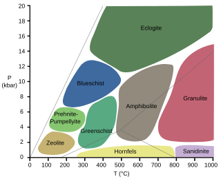
Eclogitization is the tectonic process in which the high-pressure, metamorphic facies, eclogite, is formed. This leads to an increase in the density of regions of Earth's crust, which leads to changes in plate motion at convergent boundaries.

The opening of the North Atlantic Ocean is a geological event that occurred over millions of years, during which the supercontinent Pangea broke up. As modern-day Europe and North America separated during the final breakup of Pangea in the early Cenozoic Era, they formed the North Atlantic Ocean. Geologists believe the breakup occurred either due to primary processes of the Iceland plume or secondary processes of lithospheric extension from plate tectonics.
Archean subduction is a contentious topic involving the possible existence and nature of subduction in the Archean, a geologic eon extending from 4.0-2.5 billion years ago. Until recently there was little evidence unequivocally supporting one side over the other, and in the past many scientists either believed in shallow subduction or its complete non-existence. However, the past two decades have witnessed the potential beginning of a change in geologic understanding as new evidence is increasingly indicative of episodic, non-shallow subduction.

Tesserae are regions of heavily deformed terrain on Venus, characterized by two or more intersecting tectonic elements, high topography, and subsequent high radar backscatter. Tesserae often represent the oldest material at any given location and are among the most tectonically deformed terrains on Venus's surface. Diverse types of tessera terrain exist. It is not currently clear if this is due to a variety in the interactions of Venus's mantle with regional crustal or lithospheric stresses, or if these diverse terrains represent different locations in the timeline of crustal plateau formation and fall. Multiple models of tessera formation exist and further extensive studies of Venus's surface are necessary to fully understand this complex terrain.

The subcontinental lithospheric mantle (SCLM) is the uppermost solid part of Earth's mantle associated with the continental lithosphere.
The Deep Crustal Hot Zone (DCHZ), or just deep hot zone, is a zone in the lower crust where hot mantle material intrudes. In a volcanic arc setting, hot, molten material from the mantle may intrude the lower crust. This hot material generates a new, more evolved melt in this area of the crust, which may collect and migrate upwards towards the upper crust. Here, it would collect in a magma chamber and later erupt.
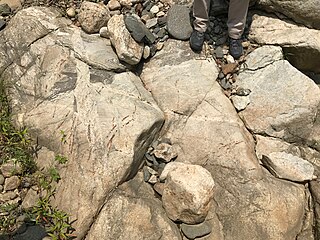
Tonalite-trondhjemite-granodiorite rocks or TTG rocks are intrusive rocks with typical granitic composition but containing only a small portion of potassium feldspar. Tonalite, trondhjemite, and granodiorite often occur together in geological records, indicating similar petrogenetic processes. Post Archean TTG rocks are present in arc-related batholiths, as well as in ophiolites, while Archean TTG rocks are major components of Archean cratons.
