
Andalusia is the southernmost autonomous community in Peninsular Spain. Andalusia is located in the south of the Iberian Peninsula, in southwestern Europe. It is the most populous and the second-largest autonomous community in the country. It is officially recognised as a historical nationality and a national reality. The territory is divided into eight provinces: Almería, Cádiz, Córdoba, Granada, Huelva, Jaén, Málaga, and Seville. Its capital city is Seville. The seat of the High Court of Justice of Andalusia is located in the city of Granada.

Cádiz is a province of southern Spain, in the southwestern part of the autonomous community of Andalusia. It is the southernmost part of mainland Spain, as well as the southernmost part of continental Europe.
Tarifa is a Spanish municipality in the province of Cádiz, Andalusia. Located at the southernmost end of the Iberian Peninsula, it is primarily known as one of the world's most popular destinations for windsports. Tarifa lies on the Costa de la Luz and across the Strait of Gibraltar facing Morocco.
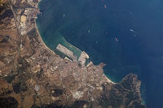
Algeciras is a municipality of Spain belonging to the province of Cádiz, Andalusia. Located in the southern end of the Iberian Peninsula, near the Strait of Gibraltar, it is the largest city on the Bay of Gibraltar.

The Battle of Río Salado also known as the Battle of Tarifa was a battle of the armies of King Afonso IV of Portugal and King Alfonso XI of Castile against those of Sultan Abu al-Hasan 'Ali of the Marinid dynasty and Yusuf I of Granada.
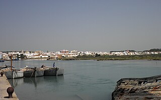
Barbate is a Spanish municipality in the Province of Cádiz, in the autonomous community of Andalusia. It is a coastal town located on the shores of the Atlantic Ocean, close to the Strait of Gibraltar. Covering a total area of 142.17 km2, it has, as of 2019, a registered population of 22,518.

Zahara de los Atunes is a village on the Costa de la Luz of Spain in the province of Cádiz and the autonomous region of Andalusia. It is noted for its excellent beaches, an outdoor cinema, and la Iglesia Del Carmen church where, curiously, tuna were butchered and salted. Also in the town are excellent facilities including a variety of restaurants, cafes and hotels.

Bahía de Cádiz Natural Park is a 10,522-hectare (26,000-acre) natural park located in the province of Cádiz. It was established in 1989.

Cahuita is a district of the Talamanca canton, in the Limón province of Costa Rica. It is located on the Caribbean coast.

Cala Arenas is a beach situated near the city of Algeciras in Spain, within the El Estrecho Natural Park. It is located at the southern end of the Bay of Gibraltar and faces the Strait of Gibraltar. It measures about 400 metres (1,300 ft) long by about 30 metres (98 ft) deep. The beach is somewhat difficult to access, but can be reached via coastal paths from Punta Carnero and Punta del Fraile. It consists of a series of three small coves of similar appearance, with beaches of rocks and small stones. Both the terrestrial and marine environment of the area lies within the natural park. Its surroundings are largely undisturbed by human activity; the nearest settlement is the coastal community of Getares, a small outlying development of the city of Algeciras located about 1 km to the north. The beach is framed by cliffs and the Isla de las Palomas lies a short distance offshore.

Playa de El Rinconcillo is a beach in the Province of Cadiz, Andalusia, Spain, located to the north of the city of Algeciras, near the neighborhood of El Rinconcillo. It looks across to the rock of Gibraltar and La Línea de la Concepción.
Playa de La Hacienda is a beach in the municipality of La Línea de la Concepción, in the Province of Cádiz, Andalusia, Spain. It has a length of about 4.3 kilometres (2.7 mi) and average width of about 90 metres (300 ft). It is a busy beach north of the city and bordered to the south with the Playa de Torrenueva and to the north with the Playa de La Alcaidesa.

Valdevaqueros is a village and beach in the municipality of Tarifa in the Province of Cadiz in southern Spain. It is located 9.7 kilometres (6.0 mi) by road to the northwest of Tarifa. Casa de Porros is a hamlet in the northwestern part. the beach measures about 4,050 metres (13,290 ft) by about 120 metres (390 ft) on average. Valdevaqueros has the Spin Out Kite surfing centre, established in 1988, and beachhouse and several hotels and a camping site and is a busy beach during the summer months, and borders the Playa de Los Lances. Behind a large dune created to protect the Punta Paloma coastal battery. Arroyo Valdevaqueros, on the eastern entrance point has several houses and a coast-guard station. In the western part of the beach is the mouth of the river valley that forms a broad estuary that runs along the beach a few metres from the sea until reaching several hundred metres east.
The siege of Algeciras (1342–1344) was undertaken during the Reconquest of Spain by the Castillian forces of Alfonso XI assisted by the fleets of the Kingdom of Aragon and the Republic of Genoa. The objective was to capture the Muslim city of Al-Jazeera Al-Khadra, called Algeciras by Christians. The city was the capital and the main port of the European territory of the Marinid Empire.

The Intercontinental Biosphere Reserve of the Mediterranean is the first of its type to be designated by the Man and the Biosphere Programme. It combines the Tingitan Peninsula in Morocco and the southern Iberian Peninsula of Andalusia. Both countries are located in a biogeographic region of deciduous forests and evergreen sclerophyllous scrub within the Mediterranean bioclimatic zone. The maritime area of the biosphere reserve is dominated by the Strait of Gibraltar, which links the two peninsulas. The reserve also encompasses natural and human communication routes between Africa and Europe.

The La Lanzada beach is one of the most famous beaches in Galicia (Spain). It is located in the municipalities of O Grove and Sanxenxo in the province of Pontevedra. The blue flag has been flying there for a long time.

The topographical relief of Spain is characterized by being quite high, with an average altitude of 660 meters above sea level, quite mountainous compared to other European countries and only surpassed by Switzerland, Austria, Albania, Montenegro, North Macedonia and the microstates of Andorra and Liechtenstein. In peninsular Spain, the terrain is articulated around a large Meseta Central that occupies most of the center of the Iberian Peninsula. Outside the plateau, there is the depression of the Guadalquivir river, located in the southwest of the peninsula, and the Ebro river depression, located in the northeast.

