San Pedro is a community within the city of Los Angeles, California. Formerly a separate city, it consolidated with Los Angeles in 1909. The Port of Los Angeles, a major international seaport, is partially located within San Pedro. The district has grown from being dominated by the fishing industry to become primarily a working class community within the city of Los Angeles.

The Richmond District is a neighborhood in the northwest corner of San Francisco, California, developed initially in the late 19th century. It is sometimes confused with the city of Richmond, which is 20 miles (32 km) northeast of San Francisco.
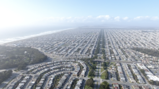
The Sunset District is a neighborhood located in the west-central area of San Francisco, California, United States. It is the largest neighborhood in the West Of Twin Peaks Neighborhoods in San Francisco.

Playa del Rey is an affluent beachside community in the Westside of the city of Los Angeles, California. It has a ZIP code of 90293 and area codes of 310 and 424. As of 2014, the Playa del Rey population was 12,129 people. Since 2000, it has had a population growth of 14.61 percent.

Edgewater is a lakefront community area on the North Side of the city of Chicago, Illinois seven miles north of the Loop. As one of the city’s 77 official community areas, Edgewater is bounded by Foster Avenue on the south, Devon Avenue on the north, Ravenswood Avenue on the west, and Lake Michigan on the east. Edgewater contains several beaches that residents enjoy during the late spring, summer, and early autumn. Chicago's largest park, Lincoln Park, stretches south from Edgewater for seven miles along the waterfront, almost to downtown. Historically, Edgewater was the northeastern corner of Lake View Township, an independent suburb annexed by the city of Chicago in 1889. Today, the Uptown community is to Edgewater's south, Lincoln Square to its west, West Ridge to its northwest and Rogers Park to its north.

The Palos Verdes Peninsula is a landform and a geographic sub-region of the Los Angeles metropolitan area, within southwestern Los Angeles County in the U.S. state of California. Located in the South Bay region, the peninsula contains a group of affluent cities in the Palos Verdes Hills, including Palos Verdes Estates, Rancho Palos Verdes, Rolling Hills and Rolling Hills Estates. The South Bay city of Torrance borders the peninsula on the north, the Pacific Ocean is on the west and south, and the Port of Los Angeles is east. The population of the Palos Verdes Peninsula is 42,364.

The ABC Unified School District is a school district that is based in Cerritos, California, United States.

Belmont Heights is a district in the south-east portion of the city of Long Beach, California, United States, bordering the Pacific Ocean and the more commercial community of Belmont Shore. The district commemorates the old City of Belmont Heights, which was incorporated in 1908 and annexed to Long Beach in 1909. Belmont Heights' borders are Ocean Boulevard and Livingston Drive to the south, Redondo Avenue on the west, 7th Street to the North, and Nieto Avenue to the east. The area is mostly residential, but also has an active business district, the strip of Broadway east of Redondo Avenue.
The western border of Santa Monica, California is the 3-mile (4.8 km) stretch of Santa Monica Bay. On its other sides, the city is bordered by various districts of Los Angeles: the northwestern border is Pacific Palisades, the eastern border is Brentwood north of Wilshire Boulevard and West Los Angeles south of Wilshire, the northeastern border is generally San Vicente Boulevard up to the Riviera Country Club, the southwestern border is Venice Beach and the southern border is with West Los Angeles and Mar Vista.
Bixby Knolls is a neighborhood in Long Beach, California.
Lakewood Village or simply known as the Village is a neighborhood in the northeast portion of the city of Long Beach, California. It is bordered on the west, north and east sides by the city of Lakewood. It is located south of Del Amo Boulevard, north of Carson Street, east of Lakewood Boulevard and west of Bellflower Boulevard.

West Colfax is a neighborhood of Denver, Colorado. The neighborhood is located in the West Denver area. In 2015 the population of the neighborhood was 9,120, and there were 4,055 housing units.

Long Beach, California, is composed of many different neighborhoods. Some neighborhoods are named after thoroughfares, while others are named for nearby parks, schools, or city features.
Lakewood Heights is a residential neighborhood in Dallas, Texas (USA), bounded by Abrams Road to the east, Monticello Avenue to the north, Skillman Street to the west, and Richmond Avenue to the south. It is in the area known as East Dallas. Lakewood Heights is approximately one-half mile (0.8 km) wide (east-west) and three-quarters of a mile (1.2 km) long (north-south). It covers approximately 240 acres or slightly less than 0.375 square miles (1000m²). It is adjacent to several East Dallas neighborhoods, including Lakewood, Lower Greenville, and Wilshire Heights.