Related Research Articles

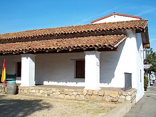
El Presidio Real de Santa Bárbara, also known as the Royal Presidio of Santa Barbara, is a former military installation in Santa Barbara, California, United States. The presidio was built by Spain in 1782, with the mission of defending the Second Military District in California. In modern times, the Presidio serves as a significant tourist attraction, museum and an active archaeological site as part of El Presidio de Santa Barbara State Historic Park.
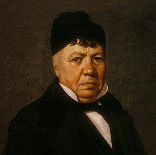
José Antonio de la Guerra y Noriega was a Californio military officer, ranchero, and founder of the prominent Guerra family of California. He served as the Commandant of the Presidio of Santa Barbara and the Presidio of San Diego.

The Santa Barbara Metropolitan Transit District (MTD) is a public transit agency providing bus service in the southern portion of Santa Barbara County, California. It serves the cities of Santa Barbara, Carpinteria, and Goleta as well as the unincorporated areas of Montecito, Summerland, and Isla Vista.
The Casa de la Guerra was the residence of the fifth commandant of the Presidio de Santa Barbara, José de la Guerra y Noriega, founder of the Guerra family of California from 1828 until his death in 1858. Descendants of José lived in the home until 1943. The site is currently owned and operated by the Santa Barbara Trust for Historic Preservation as a historic house museum. The address is 15 East De la Guerra Street, Santa Barbara, California.

Alameda Park located in Santa Barbara, California, in the U.S., adjoining Alice Keck Park Memorial Gardens, is the location for many citywide celebrations, including Summer Solstice. It is also one of the city's oldest parks.
Pablo de la Guerra was a Californio politician, judge, and signer of the Californian Constitution in 1849. He served as acting Lieutenant Governor of California and as a member of the California Senate.

The Paseo de la Guerra is a complex of historic buildings in downtown Santa Barbara, California. Since 1977 it is listed in National Register of Historic Places. It is named for the Guerra family of California, a historically prominent Californio family in Santa Barbara.
Rancho Los Álamos was a 48,803-acre (197.50 km2) Mexican land grant in present-day Santa Barbara County, California given in 1839 by Governor Juan Alvarado to José Antonio de la Guerra, a son of José de la Guerra y Noriega. Los Álamos is Spanish for "the cottonwoods" and describes Frémont's Cottonwood (Populus fremontii) trees lining the banks of the San Antonio Creek.
Rancho El Conejo was a 48,572-acre (196.56 km2) Spanish land grant in California given in 1803 to Jose Polanco and Ygnacio Rodriguez that encompassed the area now known as the Conejo Valley in southeastern Ventura and northwestern Los Angeles Counties. El Conejo means "The Rabbit" in Spanish, and refers to the many rabbits common to the region. The east-west grant boundaries approximately went from the border of Westlake Village near Lindero Canyon Road in the east to the Conejo Grade in the west. The north-south borders extended from the top of the Simi Hills at the end of Moorpark Road in the north to Hidden Valley in the Santa Monica Mountains in the south. The rancho is the site of the communities of Newbury Park, Thousand Oaks, and Westlake Village.
Rancho Santa Paula y Saticoy was a 17,773-acre (71.92 km2) Mexican land grant in the Santa Clara River Valley, in present-day Ventura County, California, and granted in 1843 by Governor Manuel Micheltorena to Manuel Jimeno Casarin. The rancho lands include the eponymous communities of Saticoy and Santa Paula along the Santa Clara River.

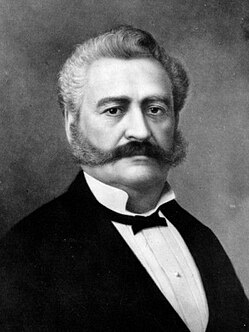
Antonio María de la Guerra was a Californio politician and military officer, who served in the California Senate and twice as Mayor of Santa Barbara. He also commanded the 1st California Cavalry Battalion during the Civil War and later served several terms on the Santa Barbara County Board of Supervisors.
Rancho San Julian was a 48,222-acre (195.15 km2) Mexican land grant and present-day ranch in present-day Santa Barbara County, California given in 1837 by Governor Juan B. Alvarado to José de la Guerra y Noriega. The grant name probably refers to José Antonio Julian de la Guerra. The grant was located west of present-day Santa Barbara.
Rancho Las Posas was a 26,623-acre (107.74 km2) Mexican land grant in present-day Ventura County, California. It was given in 1834 by Governor José Figueroa to José Antonio Carrillo.
Rancho Todos Santos y San Antonio was a 20,772-acre (84.06 km2) Mexican land grant in present-day Santa Barbara County, California given in 1841 by Governor Juan B. Alvarado to William Edward Petty Hartnell. The grant extended along San Antonio Creek and encompassed present-day Orcutt., northwest of Lompoc
Rancho Cuyama was a 48,827-acre (197.60 km2) Mexican land grant in present day eastern Santa Barbara County, California given in 1846 by Governor Pío Pico to Cesario Lataillade. The grant extended along Cuyama River in the Cuyama Valley, near Cuyama and New Cuyama. There were two Mexican land grants made in the lower Cuyama Valley: on the north Rancho Cuyama granted in 1843 and to the south Rancho Cuyama granted in 1846.
Rancho Cuyama was a 22,193-acre (89.81 km2) Mexican land grant in present-day eastern Santa Barbara County, California given in 1843 by Governor Manuel Micheltorena to José María Rojo. The grant extended along Cuyama River in the Cuyama Valley, near Cuyama and New Cuyama. There were two Mexican land grants made in the lower Cuyama Valley: on the north Rancho Cuyama granted in 1843, and to the south Rancho Cuyama granted in 1846.
Rancho La Zaca was a 4,458-acre (18.04 km2) Mexican land grant in present-day central Santa Barbara County, California given in 1838 by Governor Juan B. Alvarado to Antonio, an Indian. The grant was located along Zaca Creek, north of Rancho Corral de Cuati and surrounded by Rancho La Laguna, east of the Santa Ynez Valley.
Rancho Corral de Cuati was a 13,322-acre (53.91 km2) Mexican land grant in present-day Santa Barbara County, California given in 1845 by Governor Pío Pico to Agustín Dávila. The grant was located along Alamo Pintado Creek, north of present-day Los Olivos. The grant is surrounded by Rancho La Laguna.
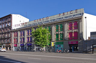
The Circo Price, also known as El Price, is a 2,142-seat concert venue and former circus in Madrid.
The Guerra family was a prominent Californio family of Southern California. Members of the family held extensive rancho grants and numerous important positions, including numerous Mayors of Santa Barbara, California Senators, a Lieutenant Governor of California, and a signer of the California Constitution.
References
- ↑ Santa Barbara Parks - Plaza de la Guerra
- ↑ Santa Barbara Independent - Plaza de la Guerra: Santa Barbara's Social Center
- ↑ Santa Barbara Trust for Historic Preservation - Architectural History
- ↑ Days, M.L. (1977), Histories of individual parks Santa Barbara California. Santa Barbara, CA: City Planning Committee.
Coordinates: 34°25′11″N119°41′55″W / 34.41972°N 119.69861°W