Plymouth Trading Post

Last updated
Plymouth Trading Post
USA California location map.svg
Red pog.svg
Location of Plymouth Trading Post in California
Usa edcp location map.svg
Red pog.svg
Plymouth Trading Post (the United States)
Location9454 Main Street Plymouth, California in Amador County
Coordinates 38°28′52″N120°50′51″W / 38.481133°N 120.847549°W / 38.481133; -120.847549
Reference no.470

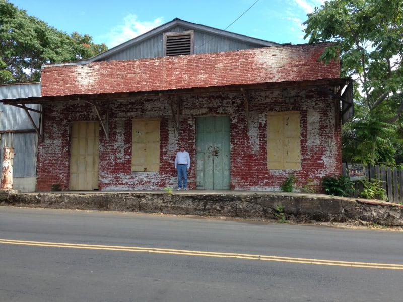
The Plymouth Trading Post is a brick building in Plymouth, California in Amador County, United States. The brick building was built in 1857 by hand by Joe Williams in 1857, to be his Trading Post. The Trading Post closed and the building became the headquarters of Plymouth Consolidated Mine in 1873. Plymouth Consolidated Mine was formed when a number of small mines combined. The building was the Plymouth Consolidated Mine main office and its commissary. Plymouth Trading Post is registered as California Historical Landmark #41, starting August 30, 1950. [1] [2] The Trading Post served the town and nearby Plymouth Mine. The building survived the 1877 that burned down much of the town. The brick walls foundations are 30 inches thick. The floor support beams are 12x12 inches of wood. Joe Williams "dug" the basement with dynamite to remove the shale rock below the building. There were hitching posts ring on the side of the building. [3] Plymouth Consolidated Mine's Pacific shaft, was the deepest hard rock shaft at 4,450 feet by 1925 working the Plymouth gold vain. The main haul of gold was between 1883 and 1889, when it operated 160 stamps that crushed 400 tons of quartz ore a day. The Plymouth Consolidated Mine mined over $13,500,000 dollars of gold and closed in 1947. [4] Some of the mines that Consolidated in 1883 were: Plymouth, Empire, and Amador Pacific mining companies. The mines were all located in the northern part of Mother Lode Gold Belt of the Sierra Nevada foothills at an elevation of 332 feet. After consolidation, the company had 126.3 acres of land that included: the Plymouth, Southerland, Oaks, Pacific, Simpson, Aden, Reese, Phoenix East claims, the Phoenix mill site, and interests in the Reese and Woolford, Indiana, Rising Star, Conville, and Beta claims. The first gold in the area was found in 1852. The Plymouth Consolidated Mine was idle from 1892 to 1911. [5] [6] [7]

Contents

See also

Related Research Articles

<span class="mw-page-title-main">Sutter's Fort</span> Historic park in Sacramento, California

Sutter's Fort was a 19th-century agricultural and trade colony in the Mexican Alta California province. Established in 1839, the site of the fort was originally called New Helvetia by its builder John Sutter, though construction of the fort proper would not begin until 1841. The fort was the first non-indigenous community in the California Central Valley. The fort is famous for its association with the Donner Party, the California Gold Rush, and the formation of the city of Sacramento, surrounding the fort. It is notable for its proximity to the end of the California Trail and Siskiyou Trails, which it served as a waystation.

<span class="mw-page-title-main">Amador County, California</span> County in California, United States

Amador County is a county located in the U.S. state of California, in the Sierra Nevada. As of the 2020 census, the population was 40,474. The county seat is Jackson. Amador County, located within California's Gold Country, is known as "The Heart of the Mother Lode". There is a substantial viticultural industry in the county.

<span class="mw-page-title-main">Jackson, California</span> City in California, United States

Jackson is a city in and the county seat of Amador County, California. Its population was 4,651 at the 2010 census, up from 3,989 at the 2000 census. The city is accessible by both State Route 49 and State Route 88.

<span class="mw-page-title-main">Sutter Creek, California</span> City in California, United States

Sutter Creek is a city in Amador County, California, United States. The population was 2,501 at the 2010 census, up from 2,303 at the 2000 census. It is accessible via State Route 49.

<span class="mw-page-title-main">Gold Country</span> Historic gold-mining region in Northern California

The Gold Country is a historic region in the northern portion of the U.S. state of California, that is primarily on the western slope of the Sierra Nevada. It is famed for the mineral deposits and gold mines that attracted waves of immigrants, known as the 49ers, during the 1849 California Gold Rush.

<span class="mw-page-title-main">Virginia City, Nevada</span> Census-designated place in Nevada, United States

Virginia City is a census-designated place (CDP) that is the county seat of Storey County, Nevada, and the largest community in the county. The city is a part of the Reno–Sparks Metropolitan Statistical Area.

<span class="mw-page-title-main">Comstock Lode</span> Lode of silver ore in Virginia City, Nevada

The Comstock Lode is a lode of silver ore located under the eastern slope of Mount Davidson, a peak in the Virginia Range in Virginia City, Nevada, which was the first major discovery of silver ore in the United States and named after American miner Henry Comstock.

<span class="mw-page-title-main">California State Route 49</span> Highway in California

State Route 49 is a north–south state highway in the U.S. state of California that passes through many historic mining communities of the 1849 California gold rush and it is known as the Golden Chain Highway. The highway's creation was lobbied by the Mother Lode Highway Association, a group of locals and historians seeking a single highway to connect many relevant locations along the Gold Rush to honor the 49ers. One of the bridges along SR 49 is named for the leader of the association, Archie Stevenot.

<span class="mw-page-title-main">California Caverns</span>

California Cavern is a Limestone cave in the Sierra Nevada foothills, in Cave City, Calaveras County, California.

Archie Stevenot was a prominent citizen in Calaveras County, California and Supreme Noble Grand Humbug of E Clampus Vitus. Born in Carson Hill, Stevenot helped found the California Chamber of Commerce and his family established the borax industry in the state. He also established the Mother Lode Highway Association in 1919 which was primarily responsible for the creation of State Route 49. As a result, the bridge across the Stanislaus River between Tuolumne and Calaveras counties on SR 49 is named the Archie Stevenot Bridge in his honor, and his birthplace has been declared a California Historical Landmark No. 769.

<span class="mw-page-title-main">Marshall Gold Discovery State Historic Park</span> State park in California

Marshall Gold Discovery State Historic Park is a state park of California, United States, marking the discovery of gold by James W. Marshall at Sutter's Mill in 1848, sparking the California Gold Rush. The park grounds include much of the historic town of Coloma, California, which is now considered a ghost town as well as a National Historic Landmark District. The park contains thre California Historical Landmarks: a monument to commemorate James Marshall (#143), the actual spot where he first discovered gold in 1848 (#530). Established in 1942, and Coloma Road (#748),. The park now comprises 576 acres (233 ha) in El Dorado County.

<span class="mw-page-title-main">Havilah, California</span> Unincorporated community in California, United States

Havilah is an unincorporated community in Kern County, California. It is located in the mountains between Walker Basin and the Kern River Valley, 5 miles (8.0 km) south-southwest of Bodfish at an elevation of 3,136 feet (956 m).

<span class="mw-page-title-main">Butte City, Amador County, California</span> Unincorporated community in California, United States

The Butte store is the only structure still standing of the original mining town of Butte City. It used to be one of 100 buildings. It was built in 1857 by Enrico Bruni, an Italian stonemason. It is made of brick and fieldstone from Calaveras. It also has three doors made of iron. Xavier Benoist used it as a store and bakery. The building served as a post office. It was also a general store called Ginocchio's. The Ginnochio family owned it for 50 years. It closed in the 1900s. It is a California Historical Landmark.

<span class="mw-page-title-main">Mariposa County Courthouse</span> United States historic place

The Mariposa County Courthouse in Mariposa, California was built in 1854, making it the oldest courthouse in California. It was listed as a California Historical Landmark in 1977.

<span class="mw-page-title-main">Big Bar (Amadour County, California)</span> Gold mine in California, United States

The Big Bar, also called Upper Bar, is a gold mine in Jackson, California, United States. The mine opened in 1848 along the Mokelumne River and is registered as California Historical Landmark #41.

The Pioneer Jewish Synagogue was built in 1857, the historic wooden building was located in Jackson, California in Amador County. Jackson's Jewish synagogue was located on the southeast corner of Church Street and Main Street. The synagogue was dedicated on September 18, 1857, by members of Congregation B'nai Israel of Jackson. The synagogue was built during the California Gold Rush, and was the first in Mother Lode country. The synagogue was used till 1869, when the Congregation outgrew the building and moved its Jewish High Holy days Services to the town's larger Jackson Masonic Hall built in 1854. The Jewish synagogue building was used as a schoolhouse from 1869 to 1888. In 1888 the building was moved to a nearby vacant lot and became a private home. The house was taken done in 1948.

The site of the Old Mining Camp of Brownsville is a California Historical Landmark on Pennsylvania Gulch Road east of the town of Murphys, California in Calaveras County. The Mining Camp of Brownsville was a California Gold Rush camp in Pennsylvania Gulch in from 1850 to 1870. The camp is named after Alfred Brown, who was the former owner of the Table Mountain Ranch. There were many rich mines in the area and Brownsville Mining Camp supported this activity. So rich was the area, the Brownsville Mining District limited the size of mines in the District. Each miner could claim and own only one wet and one dry site, no larger than 150 square feet each. Brownsville Mining District was in the area of Pennsylvania Gulches and Missouri Gulches 2 miles from Murphys. There are no remains of the camp, but nearby is the Brownsville Mining District Cemetery. A plaque monument was dedicated on July 19, 1953, by California State Park Commission with the monument base built by Christa Parlor No. 137 and Ruby Parlor No. 49 of the Native Daughters of the Golden West.

<span class="mw-page-title-main">Double Springs, California</span> Historical Landmark, form town in California, United States

Double Springs, California, is a historical site of the form town in Calaveras County, now in Valley Springs, California. The town was built during the California Gold Rush. Double Springs was founded on February 18, 1850, two years after the start of the California Gold Rush. Double Springs grew so quickly that it was the seat of Calaveras County in 1850. The County seat was a coveted honor and a year later, in 1851, Jackson was able to claim the title, but only for a year. In 1852 by popular vote, Mokelumne Hill was able to become the County seat until 1866 when it move to San Andreas. The Double Springs was in what is called the California Mother Lode mining region. The Double Springs old courthouse was built in 1849, and was moved, its original spot is now rural land. A foundation mark was placed at the site of the old courthouse, installed by the Calaveras Chamber of Commerce. The courthouse is now at the Calaveras County Museum Complex in San Andreas. Double Springs received its name from two springs nearby springs that are between the low hills nearby. Alexander R. Wheat built a large house from squared sandstone in 1860, the house is still there. One of the other remains of Double Springs is a family cemetery. Double Springs site is about 3.6 miles east of Valley Springs and is mostly rural land near Youngs Creek. The site of Double Springs is a California Historical Landmark No. 264.

<span class="mw-page-title-main">Hangman's Tree</span> Historical Landmark in Placerville, California, United States

Hangman's Tree was a tree in Placerville, California. The site of the tree is a California Historical Landmark No. 141, in El Dorado County, California. The stump of the tree is now under the building at 305 Main Street. During the California Gold Rush, the city was called Dry Diggins after the gold mining camp, but was known as Hangtown, as vigilantes hung many men for different types of crimes. During the Gold Rush, the site was Elstner's Hay Yard, next to the Jackass Inn. Hangtown was later renamed Placerville.

<span class="mw-page-title-main">Plumas House</span> Historical Landmark in Quincy, United States

Plumas House was a historical building in Quincy, California. The site of the Plumas House building is a California Historical Landmark No. 480. The first building at the site was built in 1853. The second building that replaced the original was built by James and Jane Edwards in 1866. The Edwards building was a Hotel with a Ballroom, restaurant, and parlor. The Hotel caught fire on June 23, 1923, with no hope to save it. The fire did not spread to other buildings with the help of the volunteer fire department. The two buildings served the town and the 49er California Gold Rush miners. The town of Quincy was named by James Bradley after his hometown of Quincy, Illinois. The Plumas House was busy, as Quincy was the county seat for Plumas County. A historical marker is in the town center park at the Southwest corner of Main Street and Court Street.

References

  1. "Big Bar". Office of Historic Preservation, California State Parks. Retrieved March 30, 2012.
  2. "Plymouth Trading Post (No. 470 California Historical Landmark) | Sierra Nevada Geotourism". sierranevadageotourism.org.
  3. "Plymouth Trading Post (No. 470 California Historical Landmark) | Sierra Nevada Geotourism". sierranevadageotourism.org.
  4. "City of Plymouth Historical Marker". www.hmdb.org.
  5. "Plymouth Consolidated Mine (Plymouth Mine; New London Mine; Phoenix Mine; Empire Mine; Pacific Mine; Southerland claim; Oaks and Pacific claim; Simpson and Aden claim; Reese claim; Phoenix East claim; Plymouth claim; Reese and Woolford claim; Indiana claim [fractions]; Rising Star claim; Conville and Lode claim 5181; Beta claim), Plymouth, Jackson-Plymouth Mining District, Amador County, California, USA".
  6. Plymouth Consolidated Mine, usgs.gov
  7. California Mines and Miner, Edward H. Benjamin, 1899, page 327