
The Brigach is the shorter of two streams that jointly form the river Danube in Baden-Württemberg, Germany. The Brigach has its source at 925 m (3,035 ft) above sea level within St. Georgen in the Black Forest. The Brigach crosses the city Villingen-Schwenningen. 40.4 km (25.1 mi) from the source, the Brigach joins the Breg in Donaueschingen to form the Danube River.

Freiberg is a university and former mining town in the Free State of Saxony, Germany. It is a so-called Große Kreisstadt and the administrative centre of Mittelsachsen district.

Ahr is a river in Germany, a left tributary of the Rhine. Its source is at an elevation of approximately 470 metres (1,540 ft) above sea level in Blankenheim in the Eifel, in the cellar of a timber-frame house near the castle of Blankenheim. After 18 kilometres (11 mi) it crosses from North Rhine-Westphalia into Rhineland-Palatinate.

Marienberg is a town in Germany. It was the district capital of the Mittlerer Erzgebirgskreis in the southern part of Saxony, and since August 2008 it has been part of the new district of Erzgebirgskreis. As of 2020, the town had 16,716 inhabitants.

Normalhöhennull or NHN is a vertical datum used in Germany.

The Badener Höhe is a mountain in the Northern Black Forest in the German state of Baden-Württemberg. It lies within the borough of Baden-Baden and municipality of Forbach. With a height of 1,002.5 m above sea level (NHN), it is the highest point in the borough of Baden-Baden.

At 1,176.6 m above sea level (NHN) the Obereck is the third highest mountain of the Central Black Forest after the Kandel and the Weißtannenhöhe. The three mountains also lie within the area designated as the High Black Forest.

The Teufelsmauer is a rock massif in the valley of the Black Pockau between Pobershau and Germany's state border with the Czech Republic. It is made of red and gray gneiss. The valley is also known as the Schwarzwasser. The countryside is very attractive. A channel called the Grüne Graben runs down the western slopes of the valley that used to provide the necessary water for the mines near Pobershau.
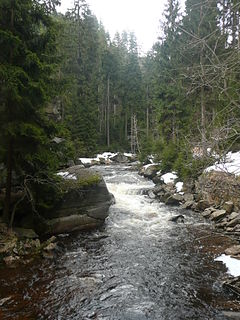
The Black Pockau is a river of Saxony, Germany, in the Ore Mountains. It is a left tributary of the Flöha. This virtually unspoilt wild stream with a length of 33 km (21 mi) is known for the picturesque gorge in its middle reaches.

The Reitzenhain–Flöha railway, one of two lines also called the Flöha Valley Railway, is a branch line in Saxony in East Germany. It links the city of Chemnitz with Flöha, Lengefeld, Pockau, Olbernhau and Marienberg, formerly also Neuhausen/Erzgeb. and Reitzenhain and runs through the valleys of the Flöha and the Black Pockau. The line belongs today to DB Regio-Netz Erzgebirgsbahn.

The Red Pockau is a 10-kilometre-long (6.2 mi) left tributary of the Black Pockau in the Ore Mountains.

Lauta is a village in the Saxon town of Marienberg in the German district of Erzgebirgskreis.

Satzung is a village in the Saxon municipality of Marienberg, which is in the district of Erzgebirgskreis in the German Ore Mountains.

The Black Forest National Park is a national park in the state of Baden-Württemberg in the southwest of Germany.

The Teufelsmühle is a mountain south of Loffenau in the Northern Black Forest. It lies between the valleys of the Murg in the west and the Alb in the east. The Alb rises near the eastern flank of the mountain, before reaching Bad Herrenalb a few kilometres further north. Over the summit plateau of the Teufelsmühle, which runs in a north-south direction, runs the boundary between the municipalities of Gernsbach in the Murg valley and Loffenau, both of which belong to the Baden-Württemberg county of Rastatt.

The Hohloh is a mountain, 988.3 m above sea level (NHN), on the eastern main ridge of the Northern Black Forest in Germany. It lies near the village of Kaltenbronn in the borough of Gernsbach, a town in the county of Rastatt in the German state of Baden-Württemberg. Its summit is the highest point in the borough of Gernsbach and the eastern chain of the Northern Black Forest, the ridge between the rivers Murg and Enz. A mountain pass runs northeast of the summit plateau between the two river valleys passing over the saddle of Schwarzmiss.
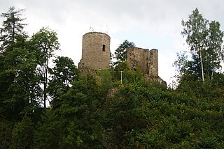
Lauterstein Castle, in German Burg Lauterstein, also called Burgruine Niederlauterstein, is a medieval castle in Niederlauterstein, town of Marienberg, Erzgebirgskreis, Saxony. It has been a ruin since the Thirty Years' War.
Niederlauterstein is a village in Saxony which has been incorporated into the town of Marienberg in the district Erzgebirgskreis since 1996.
The Pockau-Lengefeld–Neuhausen railway, one of two lines also called the Flöha Valley Railway, is a branch line in the German state of Saxony. It runs in the valley of the Flöha from Pockau via Olbernhau to Neuhausen. Since 2001, the route has been operated by Erzgebirgsbahn, part of Deutsche Bahn's RegioNetz subsidiary.

Pockau–Lengefeld station is a local railway junction in Pockau-Lengefeld in the German state of Saxony. The Pockau-Lengefeld–Neuhausen railway branches off the Reitzenhain–Flöha railway here. The station and lines were opened in 1875.


