Darnytskyi District is an urban district of the Ukrainian capital Kyiv.

Obolonskyi District is an urban district of the Ukrainian capital Kyiv. Obolonskyi District encompasses territories far beyond of its historical neighborhood sharing the same name. It was formed on 3 March 1975 and initially called as Minskyi District. In 2001 it was renamed after its historical neighborhood. Its current population is 290,000 inhabitants.
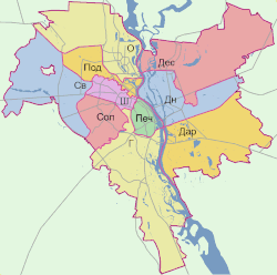
Subdivisions of Kyiv, the capital city of Ukraine, include formal administrative subdivisions known as urban districts (raions) and also more specific, informal subdivisions referred to as historical neighborhoods. The city is divided in half by the river Dnipro, and therefore creates two important portions of the capital city. The so-called "Left-bank of Kyiv", as in reference to the river Dnipro, and which is the newer half of the city, plus the "Right-bank of Kyiv", which includes the original or historic City of Kyiv.
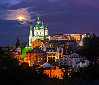
Podil or Podol or the Lower city is a historic neighborhood in Kyiv, the capital of Ukraine. It is located on a floodplain terrace over the Dnieper between the Kyiv Hills and the lower stream of Pochaina River. Podil is one of the oldest neighborhoods of Kyiv, and the birthplace of the city's trade, commerce and industry. After the Mongol invasion of Rus' and destruction of Kyiv, it served as a city center until the 19th century. Here the city administration (magistrate) and the main university were located, and later the city's port and shipyard were established here.
Poshtova Square in Kyiv, the capital of Ukraine, is one of the oldest historic squares of the city. Archaeological findings are dated back to the 4th century.
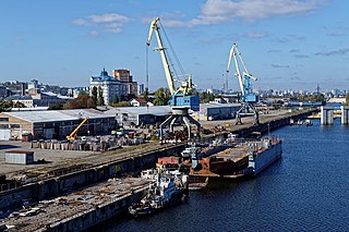
The Kyiv River Port is the main river port of Kyiv, located on the right bank of the Dnieper River in the Podil neighborhood of the city. The port has an own fleet that serves as a shipping company. It also has departments in Pereiaslav and Rzhyshchiv.

The Kyiv Tram is a tram network that serves the Ukrainian capital Kyiv. The system was the first electric tramway in the former Russian Empire and the fourth one in Europe after the Berlin, Budapest, and Prague tramways. The Kyiv Tram system currently consists of 139.9 km (86.9 mi) of the track, including 14 km (8.7 mi) of two Rapid Tram lines, served by 21 routes with the use of 523 tram cars. However, the system is being neglected, the serviced track length is decreasing at a fast rate and is replaced by buses and trolleybuses.

Square of Contracts or Contract Square is a square in the historic Podil neighborhood of Kyiv, the capital of Ukraine. The square is an important economic, cultural, and transport center of the Podil, containing numerous architectural and historical monuments.
Holosiivskyi District is an urban district of the city of Kyiv, the capital of Ukraine.

Desnianskyi District is an administrative raion of the city of Kyiv, the capital of Ukraine. It is located in the north-eastern part of the city on the Left Bank of the Dnieper River and is the most populous district of Kyiv. It is also the second largest district, with the total area of ca. 14.2 ha.
Solomianskyi District is a district in Kyiv, the capital of Ukraine. Located in the western part of the city, in the basin of Lybid river, Dniepr's tributary. Named after village of Solomianka that became part of Kyiv in 1858. Established as a district in 1921. Reogarnized in 2001. An area of the district was settled since the Middle Ages. The so-called mount of Batu Khan who invaded Kyiv in 1240 is located within the district.

Kontraktova Ploshcha is a station on Kyiv Metro's Obolonsko–Teremkivska Line. The station was opened on 17 December 1976, and is named after Kyiv's Kontraktova Square in the historic Podil neighborhood. It was designed by B.I. Pryimak, I.K. Maslenynkov, and F.M. Zaremba. The station was formerly known as Chervona Ploshcha until 1990.
The Shevchenkivskyi District is an urban district of the city of Kyiv, the capital of Ukraine. It was originally established on 4 April 1937, although in 2001 its area was increased following an annexation of the former Radianskyi and Starokyivskyi districts.

Pushcha-Vodytsia is a historic neighbourhood, climate resort and a former urban-type settlement (1981-2001) in the northwestern part of Kyiv. Located within a dense forest and away from the urban Kyiv, it is known for number of sanatoriums and state cottages for government officials such as presidents, prime-ministers etc.

The Ukrainian National Chernobyl Museum is a history museum in Kyiv, Ukraine, dedicated to the 1986 Chernobyl disaster and its consequences. It houses an extensive collection of visual media, artifacts, scale models, and other items. The museum is designed to educate the public about the many aspects of the disaster. Several exhibits depict the technical progression of the accident. There is also many areas dedicated to the loss of life and cultural ramifications of the disaster.

Sviatoshynskyi District is an urban district in the city of Kyiv located at the western part of city. The district was created in 2001 after renaming the former Leningrad District. It borders four other districts in Kyiv such as Podilskyi District, Obolonskyi District, Solomianskyi District, Shevchenkivskyi District as well as Bucha Raion that administratively is part of Kyiv Oblast. It takes its name from the historical neighbourhood of Sviatoshyn, named for the 12th century Prince Mykola Sviatosha..

The Bessarabska Square is a square located at the southwest end of Khreshchatyk, the main thoroughfare of Kyiv, the capital of Ukraine. It is located in the city's Shevchenkivskyi District (district), at the busy intersection of Khreshchatyk, Taras Shevchenko Boulevard, Velyka Vasylkivska Street, and the Krutyi Descent streets.

Kamianets-Podilskyi Raion is one of the three administrative raions (district) of Khmelnytskyi Oblast in western Ukraine. Its administrative center is located in the city of Kamianets-Podilskyi. Population: 279,789.

Hostynnyi Dvir is a trade complex built in Kyiv, Ukraine back in 1813 by Luigi Rusca.
Obolon is a historical locality which includes a residential area (masyv), along with an industrial park within Ukraine's capital Kyiv that is located on its northern side, in an eponymous city district - the Obolonskyi District.