
The Central Banat District is one of seven administrative districts of the autonomous province of Vojvodina, Serbia. It lies in the geographical region of Banat. According to the 2011 census results, it has a population of 186,851 inhabitants. The administrative center is the city of Zrenjanin.

Goalpara district is an administrative district of the Indian state of Assam.

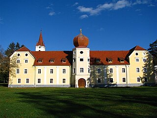
Kaptol is a village in central Slavonia, Croatia. It is located on the slopes of Papuk mountain, east of Velika and northeast of Požega. The population of the municipality is 3,472, with 1,409 people in Kaptol itself, 97% are Croats.
Macuata is one of Fiji's fourteen Provinces, and one of three based principally on the northern island of Vanua Levu, occupying the north-eastern 40 percent of the island. It has a land area of 2004 square kilometers.
The settlements included in the administrative area of Kutjevo include:
Punitovci is a municipality in Osijek-Baranja County, Croatia. There are a total of 1,803 inhabitants.
Prapcha is a village development committee in Okhaldhunga District in the Sagarmatha Zone of mid-eastern Nepal. At the time of the 1991 Nepal census it had a population of 1259 living in 249 individual households.
Cárdenas is the second-largest city in the state of Tabasco, in southeastern Mexico. It lies in the northwestern part of the state, on the Gulf of Mexico coast, east of the city of Coatzacoalcos, Veracruz. The city is the municipal seat of Cárdenas Municipality. At the census of 2005 the city had a population of 79,875 inhabitants, while the municipality had 219,563 inhabitants. There are numerous smaller communities in the municipality, but the largest are Sánchez Magallanes and Campo Magallanes. The area of the municipality is 2,112 km².
Santas Martas is a municipality located in the province of León, Castile and León, Spain. According to the 2004 census (INE), the municipality has a population of 952 inhabitants.

Velilla de Ebro is a municipality located in the Zaragoza Province, Aragon, Spain. According to the 2009 census (INE), the municipality has a population of 261 inhabitants.
Chinicuila is a municipality located in the southwestern region of the Mexican state of Michoacán. The municipality has an area of 928.64 square kilometres and is bordered to the north by the state of Jalisco, to the east by Coalcomán, to the south by Aquila, and to the west by Coahuayana and the state of Colima. The municipality had a population of 5,343 inhabitants according to the 2005 census. Its municipal seat is the city of Villa Victoria.

Beanana is a town and commune in Madagascar. It belongs to the district of Amparafaravola, which is a part of Alaotra-Mangoro Region. The population of the commune was estimated to be approximately 10,000 in 2001 commune census.

Poiana is a commune in Dâmbovița County, southern Romania with a population of 3,897 people. It is composed of two villages, Poiana and Poienița.
Brabova is a commune in Dolj County, Romania with a population of 1,776 people. It is composed of six villages: Brabova, Caraiman, Mosna, Răchita de Jos, Urdinița and Voita.

Nogowczyce is a village in the administrative district of Gmina Ujazd, within Strzelce County, Opole Voivodeship, in south-western Poland. It lies approximately 5 kilometres (3 mi) north of Ujazd, 10 km (6 mi) south-east of Strzelce Opolskie, and 41 km (25 mi) south-east of the regional capital Opole.
Bistar is a village in the municipality of Bosilegrad, Serbia. According to the 2002 census, the town has a population of 114 people.
Moštanica is a village in central Croatia, in the municipality/town of Petrinja, Sisak-Moslavina County. It is connected by the D30 highway.
Jurjevac Punitovački is a village in Croatia, part of the municipality of Punitovci, population 787 (2011).
Yunokomunarivsk is a city in Yenakiieve municipality, Donetsk Oblast (province) of Ukraine. Population: 14,154 (2013 est.), 17,813 (2001).
Bukovje Podvrško is a settlement (naselje) in the Samobor administrative territory of Zagreb County, Croatia. As of 2011 it had a population of 31 people.


