Poggatacut (sachem)

Last updated • 2 min readFrom Wikipedia, The Free Encyclopedia

Poggatacut (c. 1568 – 1651) also known as Youghco or Poggatticut, was sachem of the Manhasset Indian people of Shelter Island, New York and elder brother to Montaukett Sachem Wyandanch. Sachem Poggatacut and his wife Aswaw granted possession to Lion Gardiner for Gardiners Island in 1639. It was conveyed when they deeded Manchonat, an Island between the north and south fork in exchange for goods and alliance. By 1644 he had united the Corchaug, Shinnecock, Manhassets and Montaukett before retreating as Grand Sachem to his redoubt on Shelter Island, [1] relinquishing control over the tribes to his younger brother, sachem Wyandanch. [2] As “Sachem of Paumanacke", as Long Island was called, he was empowered to make treaties for the Montauketts. [3]

Contents

Early life

Son of Mongotucksee Longknife, Sachem of Montaukett (1550-1595) and Quashawan, of the Mohawk and Montauk Tribes (1556-1600), his 27 siblings constituted a royal family [4] that had rivals as far away as the Narragansetts of Connecticut. The Montauk Tribe of Indians were tributary or allied to the Pequots, the Narragansetts enemies.

Pequot War

Resting place of Sachem Poggatacut, also known as Sachem's hole Poggatacut historical marker 20190913 110857 (1).jpg
Resting place of Sachem Poggatacut, also known as Sachem's hole

The end of the Pequot war (1636–38) saw the Pequots decimated as the toll of contact with the Europeans via the fur trade and superior numbers of Narragansetts ended their dominance on Long Island. With the Narragansetts set to eradicate the Montaukett tribe, Poggatacut sought to ally with the settlers and Gardiner. By 1648 he was Sachem of Shelter Island and travelled from his residence on Sachem’s Neck to visit with the other tribes. It was on one of these visits that he died in 1651. His funeral train bore his body back to Montauk and stopped at Buc-Usk-Kil, [5] a place on the road from Sag Harbor to East Hampton. Indian lore has that where his head rested there was a shallow hole in the ground, approximately 1 1/2 feet deep, later called the Sachem's hole, [6] which for passing Indians became a sacred place. [7] For 200 years passing tribes would stop and remove the twigs and leaves that had fallen into the hole; until the 1950s when the roadway (E Hampton-Sag Harbor turnpike/ NY 114) was widened and the sachems hole obliterated. [8]

By 1663 East Hampton had passed laws prohibiting Indians from the town due to the smallpox plague that ravished the Montauketts. Grand sachem Wyandanch had united 13 tribes and moved the tribe off the Indian fields to gain the safety that being closer to the whites entailed. By the end of the 1800's barely 10-15 families were left on the east end. [9]

Buc-Usk-Kil

In 2001 East Hampton trustees created the Buckskill Nature Preserve, consisting of 140 acres belonging to the town and 170 acres of Suffolk county owned pine barrens. The town found preservation of the water table beneath the barrens to be beneficial to town water recharge ability and the water supply. Buc-Usk-Kil is the Algonquin word for 'resting place', the starting point for the nature preserve is between Stephen Hands Path and Daniels Hole Road on NY 114. [10]

See also

Northwest Alliance

Related Research Articles

<span class="mw-page-title-main">Montauk, New York</span> Hamlet in New York State

Montauk is a hamlet and census-designated place (CDP) in the Town of East Hampton in Suffolk County, New York, on the eastern end of the South Shore of Long Island. As of the 2020 United States census, the CDP's population was 4,318.

<span class="mw-page-title-main">Gardiners Island</span> Island off the coast of New York, United States

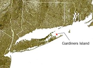
Gardiner's Island is a small island in the Town of East Hampton, New York, in Eastern Suffolk County. It is located in Gardiner's Bay between the two peninsulas at the east end of Long Island. It is 6 miles (9.7 km) long, 3 miles (4.8 km) wide and has 27 miles (43 km) of coastline.

<span class="mw-page-title-main">East Hampton, New York</span> Town in New York, United States

The Town of East Hampton is located in southeastern Suffolk County, New York, at the eastern end of the South Shore of Long Island. It is the easternmost town in the state of New York. At the time of the 2020 United States census, it had a total population of 28,385.

<span class="mw-page-title-main">Niantic people</span> Historic Native American tribe in Connecticut

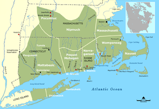
The Niantic are a tribe of Algonquian-speaking American Indians who lived in the area of Connecticut and Rhode Island during the early colonial period. The tribe's name Nehântick means "of long-necked waters"; area residents believe that this refers to the "long neck" or peninsula of land known as Black Point, located in the village of Niantic, Connecticut.

<span class="mw-page-title-main">South Fork (Long Island)</span>

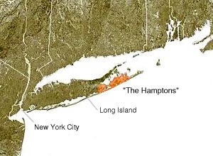
The South Fork of Suffolk County, New York is a peninsula in the southeastern section of the county on the South Shore of Long Island. The South Fork includes most of the Hamptons. The shorter, more northerly peninsula is known as the North Fork.

<span class="mw-page-title-main">Lion Gardiner</span> English engineer and colonist

Lion Gardiner (1599–1663) was an English engineer and colonist who founded the first English settlement in New York, acquiring land on eastern Long Island. He had been working in the Netherlands and was hired to construct fortifications on the Connecticut River, for the Connecticut Colony. His legacy includes Gardiners Island, which is held by his descendants.

<span class="mw-page-title-main">Montaukett</span> Native northeastern American people

The Montaukett ("Metoac"), more commonly known as Montauk, are an Algonquian-speaking Native American people from the eastern and central sections of Long Island, New York.

Wyandanch (c. 1571 – 1659) was a sachem of the Montaukett Indians in the mid-17th century on eastern Long Island. Initially he was a minor chief among the Montaukett, but due to his skillful manipulation of various alliances and his accommodating stance towards the European colonists who gave him substantial military and economic support, he eventually became an influential "alliance chief" (a sachem who was responsible for maintaining friendly relations between his tribe and the settlers).

<span class="mw-page-title-main">Stephen Talkhouse</span>

Stephen Talkhouse was a Montaukett Native American of the late 19th century who was famed for his 25–50 mile daily round trip walks from Montauk, New York to East Hampton and Sag Harbor. Landmarks along the route have been named for him.

<span class="mw-page-title-main">Paumanok Path</span>

The Paumanok Path is a 125-mile (201 km) hiking trail in New York on Long Island that goes from Rocky Point to Montauk Point State Park. It travels through four towns in Suffolk County: Brookhaven, Riverhead, Southampton and East Hampton. It is marked by white trail blazes.

<span class="mw-page-title-main">Shinnecock Indian Nation</span> Federally-recognized Native American tribe of Long Island, New York

The Shinnecock Indian Nation is a federally recognized tribe of historically Algonquian-speaking Native Americans based at the eastern end of Long Island, New York. This tribe is headquartered in Suffolk County, on the southeastern shore. Since the mid-19th century, the tribe's landbase is the Shinnecock Reservation within the geographic boundaries of the Town of Southampton. Their name roughly translates into English as "people of the stony shore".

<span class="mw-page-title-main">Metoac</span>

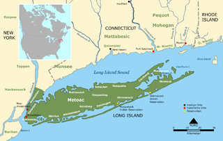
Metoac is an erroneous term used by some to group together the Munsee-speaking Lenape (west), Quiripi-speaking Unquachog (center) and Pequot-speaking Montaukett (east) American Indians on what is now Long Island in New York state. The term was invented by amateur anthropologist and U.S. Congressman Silas Wood in the mistaken belief that the various native settlements on the island each comprised distinct tribes.

<span class="mw-page-title-main">Montauk Point land claim</span> Series of 1879 lawsuits in New York State

The Montauk Point land claim was a series of three lawsuits brought by Chief Wyandank Pharaoh, nephew of the Stephen Talkhouse who died in the same year (1879) that the tribe lost the last remaining vestige of their territory in the New York state courts, claiming Montauk Point on behalf of the Montaukett Indians, against the Long Island Rail Road (LIRR) and its predecessors in title.

<span class="mw-page-title-main">Hilda Lindley House</span>

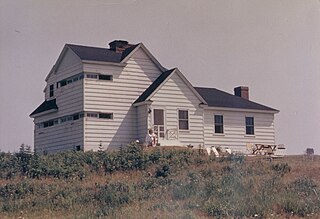
The Hilda Lindley House is a former U.S. Army fire control station in Indian Field in Montauk, New York. The house is named for the woman who lived there and saved Indian Field from development in the 1970s, but who had her house taken from her by Suffolk County as a result.

<span class="mw-page-title-main">Cockenoe</span> 17th century Native American translator

Cockenoe was an early Native American translator from Long Island in New York where he was a member of the Montaukett. He helped to translate the earliest parts of the Eliot Indian Bible, the first Bible published in America.

<span class="mw-page-title-main">Rev. Thomas James (Puritan)</span> United States historic place

Rev. Thomas James, Jr. (1620-1698) was a Puritan minister in East Hampton, Long Island, during the late 17th century. In 1648, the first inhabitants of East Hampton arrived, having mostly migrated from Maidstone, a town in Kent, England. Prior to reaching eastern Long Island, they made a stopover in Lynn, Massachusetts, and then moved on to Connecticut. Their journey to America was primarily driven by religious persecution and oppressive governmental regulations. These settlers sought not just religious freedom, but also civil liberties.

The Narragansett-Montaukett war was an armed conflict which began in 1653 and lasted to 1657 between the allies of the Niantic Sachem Ninigret and the Long Island tribes who were under the protection of the New England Confederation.

References

  1. W. W. Munsell, History of Suffolk County, New York, 1882, pp 19
  2. David Bunn Martine, Long Island Native Master History Timeline, 2010
  3. Faren R. Siminoff, Crossing the Sound, 2004, pp. 172
  4. "Mongotucksee Longknife Sachem of Montaukett (1550-1595) • FamilySearch". FamilySearch.
  5. "Indian Landmark Buc-Usk-Kil Historical Marker".
  6. "Sachem's Hole".
  7. "A history of the town of East-Hampton, N.Y." Sag-Harbor, J.H. Hunt, printer. 1897.
  8. "History of East Hampton, New York Chapter 7". www.longislandgenealogy.com.
  9. Strong, John A. “The Imposition of Colonial Jurisdiction over the Montauk Indians of Long Island.” Ethnohistory, vol. 41, no. 4, 1994, pp. 561–590. JSTOR, www.jstor.org/stable/482766. Accessed 22 Sept. 2020.
  10. Cohen, Zachary; Czajka, Len; D'Andrea, Paul; Ganley, Terry; Larsen, George; Lundin, Bill; Makl, Gene; Pfund, Kurt; Porco, Ed; Yates, Mitch (June 27, 2002). "Buckskill Nature Preserve: Management Plan". Town of East Hampton. Archived from the original on 2020-10-18. Retrieved 2020-09-22.
  11. "Cupola Fire Burns Hotel Poggatticut". The New York Times. August 12, 1922. p. 3.
  12. "Collections Corner". Southold Historical Museum. May 28, 2021.