Pohatcong Creek

Last updated

Pohatcong Creek (also called the Pohatcong River) is a 30.7-mile-long (49.4 km) [1] tributary of the Delaware River in northwestern New Jersey in the United States.

Tributary stream or river that flows into a main stem river or lake

A tributary or affluent is a stream or river that flows into a larger stream or main stem river or a lake. A tributary does not flow directly into a sea or ocean. Tributaries and the main stem river drain the surrounding drainage basin of its surface water and groundwater, leading the water out into an ocean.

Delaware River major river on the East coast of the United States of America

The Delaware River is a major river on the Atlantic coast of the United States. It drains an area of 14,119 square miles (36,570 km2) in five U.S. states: Delaware, Maryland, New Jersey, New York, Pennsylvania. Rising in two branches in New York state's Catskill Mountains, the river flows 419 miles (674 km) into Delaware Bay where its waters enter the Atlantic Ocean near Cape May in New Jersey and Cape Henlopen in Delaware. Not including Delaware Bay, the river's length including its two branches is 388 miles (624 km). The Delaware River is one of nineteen "Great Waters" recognized by the America's Great Waters Coalition.

New Jersey State of the United States of America

New Jersey is a state in the Mid-Atlantic and Northeastern regions of the United States. It is located on a peninsula, bordered on the north and east by the state of New York, particularly along the extent of the length of New York City on its western edge; on the east, southeast, and south by the Atlantic Ocean; on the west by the Delaware River and Pennsylvania; and on the southwest by the Delaware Bay and Delaware. New Jersey is the fourth-smallest state by area but the 11th-most populous, with 9 million residents as of 2017, and the most densely populated of the 50 U.S. states; its biggest city is Newark. New Jersey lies completely within the combined statistical areas of New York City and Philadelphia. New Jersey was the second-wealthiest U.S. state by median household income as of 2017.

Contents

It rises in the mountains of eastern Warren County, west of Hackettstown. It flows southwest, in a valley along the northwestern side of the Pohatcong Mountain ridge, which separates its watershed from that of the Musconetcong River. It joins the Delaware in Pohatcong Township, approximately 5 miles (8 kilometers) south of Phillipsburg.

Warren County, New Jersey County in the United States

Warren County is a county located in the U.S. state of New Jersey. As of the 2017 Census estimate, the county's population was 106,798, making it the 19th-most populous of the state's 21 counties, representing a decrease of 1.7% from the 108,692 enumerated in the 2010 United States Census, in turn having increased by 6,255 (+6.1%) from 102,437 counted at the 2000 Census, Its county seat is Belvidere. It is part of the Allentown-Bethlehem-Easton, PA-NJ metropolitan area and is generally considered the eastern border of the Lehigh Valley. It is considered part of the New York-Newark, NY-NJ-CT-PA Combined Statistical Area, and shares its eastern border with the New York City Metropolitan Area, with its northwestern section bordering The Poconos. The most populous place was Phillipsburg, with 14,950 residents at the time of the 2010 Census, while Hardwick Township, covered 37.92 square miles (98.2 km2), the largest total area of any municipality.

Hackettstown, New Jersey Town in New Jersey, United States

Hackettstown is a town in Warren County, in the state of New Jersey, United States. As of the 2010 United States Census, the town's population was 9,724, reflecting a decline of 679 (-6.5%) from the 10,403 counted in the 2000 Census, which had in turn increased by 2,283 (+28.1%) from the 8,120 counted in the 1990 Census. The town is located in the easternmost region of the Lehigh Valley.

Pohatcong Mountain mountain in United States of America

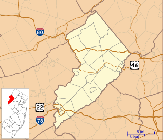
Pohatcong Mountain is a ridge, approximately 6 mi (10 km) long, in the Appalachian Mountains of northwestern New Jersey in the United States. It extends from west Phillipsburg northeast approximately to Allamuchy Township, New Jersey. The ridge continues on north past Washington as Upper Pohatcong Mountain. The term "Pohatcong Mountain" is sometimes taken to include both mountains. The ridge is approximately 800 ft high along much of its length.

See also

Related Research Articles

Musconetcong River river in the United States of America

The Musconetcong River is a 45.7-mile-long (73.5 km) tributary of the Delaware River in northwestern New Jersey in the United States. It flows through the rural mountainous country of northwestern New Jersey. Part of it is a National Wild and Scenic River.

Upper Pohatcong Mountain is a ridge in the Appalachian Mountains of northwestern New Jersey in the United States. It is located in eastern Warren County, and extends northeast of Washington approximately 6 mi (10 km) to the vicinity of Hackettstown. The ridge has an average height of approximately 800 ft and reaches a maximum summit of 1235 ft.

Chester River river in Maryland and Delaware, United States

The Chester River is a major tributary of the Chesapeake Bay on the Delmarva Peninsula. It is about 43 miles (69 km) long, and its watershed encompasses 368 sq mi (950 km2), which includes 295 sq mi (760 km2) of land. Thus the total watershed area is 20% water. It forms the border between Kent County and Queen Anne's County, Maryland, with its headwaters extending into New Castle County and Kent County, Delaware. Chestertown, the seat of Maryland's Kent County, is located on its north shore. It is located south of the Sassafras River and north of Eastern Bay, and is connected with Eastern Bay through Kent Narrows.

Alloway Creek river in the United States of America

Alloway Creek is a 23.2-mile-long (37.3 km) tributary of the Delaware River in Salem County, New Jersey in the United States. The name is a derivative of Allowas, an Indian chief. It has also been known by other names: Aloes River, Aloes Creek, Cotton River, Korten River, Short River, Monmouth River, Munmouth River, and Roiter's River.

Crosswicks Creek is a 25.3-mile-long (40.7 km) tributary of the Delaware River in Burlington County, New Jersey in the United States.

Elk River (Maryland) tidal tributary of the Chesapeake Bay on the Eastern Shore of Maryland and on the northern edge of the Delmarva Peninsula

The Elk River is a tidal tributary of the Chesapeake Bay on the Eastern Shore of Maryland and on the northern edge of the Delmarva Peninsula. It is about 15 miles (24 km) long. As the most northeastern extension of the Chesapeake Bay estuary, it has served as one entrance to the Chesapeake & Delaware Canal since the 19th century. The canal and river now serve as one boundary of the Elk Neck Peninsula. The river flows through Cecil County, Maryland, with its watershed extending into New Castle County, Delaware and Chester County, Pennsylvania. Elkton, the county seat of Cecil County, is located at its head. Its total watershed area is 143 square miles (370 km2), with 21 square miles (54 km2) of open water, so its watershed is 15% open water. It is south and east of the North East River, and north of the Sassafras River.

Marshyhope Creek river in the United States of America

Marshyhope Creek is a 37.0-mile-long (59.5 km) tributary of the Nanticoke River on the Delmarva Peninsula. It rises in Kent County, Delaware, and runs through Caroline County, Maryland, and Dorchester County, Maryland.

Pennsauken Creek is a 3.8-mile-long (6.1 km) tributary of the Delaware River in Burlington and Camden counties, New Jersey in the United States.

Shellpot Creek is a tributary of the Delaware River in northeast New Castle County, Delaware. The stream rises between Grubb Road and Shipley Road, south of Naaman's Road at 39°49′19″N75°31′55″W in Brandywine Hundred and flows southeast for about six miles before discharging into the Delaware River at 39°44′05″N75°30′16″W near Edgemoor. Prior to 1938, the stream drained into the Brandywine Creek, but was subsequently redirected to the Delaware River.

Minisink

The Minisink or Minisink Valley is a loosely defined geographic region of the Upper Delaware River valley in northwestern New Jersey, northeastern Pennsylvania and New York.

Wallpack Ridge


Wallpack Ridge is a mountain located in the Ridge and Valley Appalachians physiographic province in Sussex County in northwestern New Jersey. Oriented northeast to southwest, Wallpack Ridge spans 25 miles (40 km) from Montague Township south of Port Jervis, New York to the Walpack Bend in the Delaware River near Flatbrookville in Walpack Township. It is a narrow ridge ranging between 0.67 miles (1.08 km) to 1.7 miles (2.7 km) in width, and its highest elevation reaches 928 feet (283 m) above sea level. The ridge separates the Wallpack Valley from the valley of the Delaware River, and contains the watershed of the Flat Brook and its main tributaries Big Flat Brook and Little Flat Brook.

Wallpack Valley valley in New Jersey, United States of America

Wallpack Valley is a valley located in Sussex County in northwestern New Jersey formed by Wallpack Ridge on the west, and Kittatinny Mountain on the east. Wallpack Ridge separates the Wallpack Valley from the valley of the Delaware River, and contains the watershed of the Flat Brook and its main tributaries Big Flat Brook and Little Flat Brook. It is a narrow valley, roughly 25 miles (40 km) in length running from Montague Township south of Port Jervis, New York to the Walpack Bend in the Delaware River near Flatbrookville in Walpack Township where the Flat Brook enters the Delaware at 300 feet above sea level.

Jacksonburg Creek is a tributary of the Paulins Kill located along the eastern face of Kittatinny Mountain in Warren County in northwestern New Jersey in the United States. It rises near the Warren County-Sussex County border in Hardwick Township and enters the Paulins Kill approximately one mile south of Blairstown. The Appalachian Trail passes within its watershed and crosses the creek as it traverses the ridgeline of Kittatinny Mountain.

Yards Creek is a tributary of the Paulins Kill located along the eastern face of Kittatinny Mountain in Warren County in northwestern New Jersey in the United States. It rises along Kittatinny Mountain near Catfish Pond in Hardwick Township, flowing into the Yards Creek Reservoir and Lower Yards Creek Reservoir at Yards Creek Generating Station near Blairstown. The creek flows into the Paulins Kill near the hamlet of Hainesburg in Knowlton Township. The Appalachian Trail passes within its watershed and crosses the creek as it traverses the ridgeline of Kittatinny Mountain.

Stony Brook is a tributary of the Delaware River located along the eastern face of Kittatinny Mountain in Warren County in northwestern New Jersey in the United States. It rises along Kittatinny Mountain, and flows into the Delaware at the base of Mount Tammany, a prominence of Kittatinny Mountain that forms the New Jersey side of the Delaware Water Gap near Columbia in Knowlton Township. The Appalachian Trail passes within its watershed and crosses the creek as it traverses the ridgeline of Kittatinny Mountain.

Silver Hill is a mountain in Warren County, New Jersey. It is located in the southeastern portion of Pohatcong Township; the main summit rises to 722 feet (220 m).

References

  1. U.S. Geological Survey. National Hydrography Dataset high-resolution flowline data. The National Map, accessed April 1, 2011

Coordinates: 40°44′11″N75°01′41″W / 40.736527°N 75.027995°W / 40.736527; -75.027995

Geographic coordinate system Coordinate system

A geographic coordinate system is a coordinate system that enables every location on Earth to be specified by a set of numbers, letters or symbols. The coordinates are often chosen such that one of the numbers represents a vertical position and two or three of the numbers represent a horizontal position; alternatively, a geographic position may be expressed in a combined three-dimensional Cartesian vector. A common choice of coordinates is latitude, longitude and elevation. To specify a location on a plane requires a map projection.