Related Research Articles

The Kenai Peninsula is a large peninsula jutting from the coast of Southcentral Alaska. The name Kenai is derived from the word "Kenaitze" or "Kenaitze Indian Tribe", the name of the Native Athabascan Alaskan tribe, the Kahtnuht’ana Dena’ina, who historically inhabited the area. They called the Kenai Peninsula Yaghanen.

Gulf Islands National Park Reserve is a national park located on and around the Gulf Islands in British Columbia, Canada. In the National Parks System Plan, this park provides representation of the Strait of Georgia Lowlands natural region, the only place in Canada with a Mediterranean climate of dry, sunny summers and mild, wet winters, the result of a rain shadow effect from surrounding mountains between the region and the ocean. It has similar dominant vegetation as the Pacific Northwest, such as coastal Douglas-fir, western red cedar, shore pine, Pacific dogwood, bigleaf maple, and red alder, but also contains the northern extent of some of the more drought tolerant trees such as Garry oak and Arbutus. The park was created in 2003 as the fortieth national park. It covers 36 square kilometres (14 sq mi) of area on 16 islands and more than 30 islets, reefs and surrounding waters, making it the sixth smallest national park in Canada.

The Greenbelt is a 203.5-square-kilometre (78.6 sq mi) protected green belt traversing Ottawa, Ontario, Canada. It includes green space, forests, farms, and wetlands from Shirleys Bay in the west and to Green's Creek in the east. It is the largest publicly owned green belt in the world and the most ecologically diverse area in Eastern Ontario. The National Capital Commission (NCC) owns and manages 149.5 square kilometres (57.7 sq mi), and the rest is held by other federal government departments and private interests. Real estate development within the Greenbelt is strictly controlled.

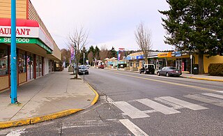
High Level is a town in northern Alberta, Canada. It is located at the intersection of the Mackenzie Highway and Highway 58, approximately 733 kilometres (455 mi) north of Edmonton and 725 km (450 mi) south of Yellowknife, Northwest Territories. High Level is located within Mackenzie County and was founded in 1947. The town serves a trading area of approximately 20,000 people.
Sechelt is a district municipality located on the lower Sunshine Coast of British Columbia. Approximately 50 km northwest of Vancouver, it is accessible from mainland British Columbia by a 40-minute ferry trip between Horseshoe Bay and Langdale, and a 25-minute drive from Langdale along Highway 101, also known as the Sunshine Coast Highway. The name Sechelt is derived from the she shashishalhem word shíshálh, the name of the First Nations people who first settled the area thousands of years ago.

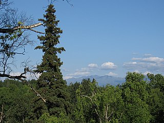
Chugach State Park covers 495,204 acres covering a hilly region immediately east of Anchorage, in south-central Alaska.
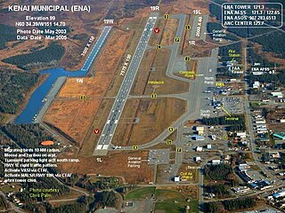
Kenai Municipal Airport is a city-owned, public-use airport located in Kenai, a city in the Kenai Peninsula Borough of the U.S. state of Alaska.

Fire Island is a 5.5-mile (8.9 km) long island in the U.S. state of Alaska, located near the head of Cook Inlet at 61°09′34″N150°11′55″W. It is the only island in the Municipality of Anchorage, sitting three miles (5 km) off the city's Point Campbell, and nine miles (14.5 km) from downtown. Its land area is 17.467 km2, and there was no permanent resident population at the 2000 census.
Anchorage, officially the Municipality of Anchorage, is the most populous city in the U.S. state of Alaska. With a population of 291,247 at the 2020 census, it contains nearly 40 percent of the state's population. The Anchorage metropolitan area, which includes Anchorage and the neighboring Matanuska-Susitna Borough, had a population of 398,328 in 2020, accounting for more than half the state's population. At 1,706 sq mi (4,420 km2) of land area, the city is the fourth-largest by area in the U.S.
Kincaid Park is a 1,516.78-acre (6.1382 km2) municipal park in Anchorage, Alaska, located at 9401 W. Raspberry Road. The park is bounded on the south by Turnagain Arm, on the west by Knik Arm, and on the north by Ted Stevens Anchorage International Airport. Noted for Nordic skiing trails, in snowless months the park is frequented by runners, bikers, hikers, archers, dog-trainers, motocross users, disc golfers, soccer teams, and rollerskiers. Other winter activities include snowshoeing, sledding and biathlon. The park was created in 1978 and later expanded to include the location of a deactivated former Nike missile site. The park continues to evolve with changing demands of local residents. In 2009, a full 18 "hole" disc golf course that meanders through the wooded Mize Loop area was completed. In 2010, several new soccer fields were completed and open for use in the area near the chalet. In 2012, a single artificial turf soccer field with stadium seating was completed just south of the park's headquarters building, Kincaid Chalet. Cook Inlet, Fire Island with its wind turbines, and Mount Susitna are visible from most hilltops in the park. On a clear day, Denali can also be seen from the park.
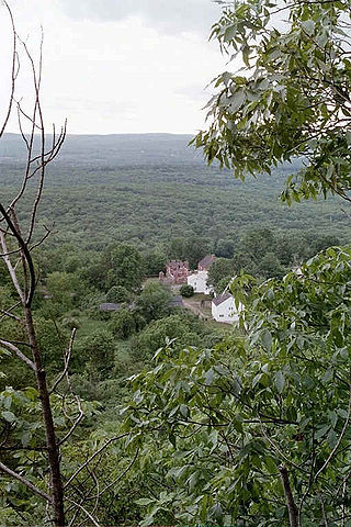
Peak Mountain, also called Copper Mountain, est. 730 feet (220 m), is a traprock mountain located in East Granby, Connecticut, 6 miles (10 km) south of the Massachusetts border and 6 miles west of the Connecticut River. It is part of the narrow, linear Metacomet Ridge that extends from Long Island Sound near New Haven, Connecticut, north through the Connecticut River Valley of Massachusetts to the Vermont border. Peak Mountain is known for its expansive views from 200 feet (61 m) high cliffs overlooking the historic Old Newgate Prison, Congamond Lake, and the Salmon Brook Valley of north-central Connecticut. The mountain is also known for its microclimate ecosystems, rare plant communities, and as a seasonal raptor migration path. It is traversed by the 51-mile (82 km) Metacomet Trail.
Bootleggers Cove is an area of Anchorage, Alaska, just west of Downtown Anchorage and north of the South Addition. Its exact boundaries are controversial. It is served by Inlet View Elementary School, Romig Junior High and West Anchorage High School. Its scenic features include Elderberry Park, the Oscar Anderson House, the Westchester Lagoon, and access to the Tony Knowles Coastal Trail and the Lainie Fleischer Bike Trail. It is located near the tidal flats of Cook Inlet. The Alaska Railroad passes between the residential zones of Bootleggers Cove and the tidal flats. Bootlegger's Cove was affected by the 1964 Alaska earthquake. It is currently represented in the Alaska State Legislature by Representative Les Gara and Senator Johnny Ellis.
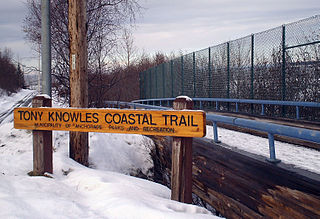
The Tony Knowles Coastal Trail is an 11-mile-long (18 km) trail along the coast of Anchorage, Alaska designated for non-motorized use. The trail runs from Second Avenue in downtown Anchorage and finishes in Kincaid Park. The trail is entirely paved, supports two-way traffic, and connects with the Chester Creek Trail. Point Woronzof Park borders the coastal trail to the east for about a mile, starting at about mile 5.0. In the summer the trail is used extensively by walkers, runners, rollerbladers, and cyclists. In the winter, the trail is used primarily for cross country skiing and also skijoring. The trail is a portion of the annual Tour of Anchorage cross country ski marathon. The trail's namesake is the former Anchorage mayor and Alaska governor.
The Naugatuck Trail is a 6.8-mile (10.9 km) Blue-Blazed hiking trail "system" in the eastern central-lower Naugatuck River Valley in New Haven County, Connecticut, USA. It is almost entirely contained in the Naugatuck State Forest. The mainline trail is primarily east to west with three short side or spur trails. Composed of four trails, at its western end the trail ends with a section alongside Route 8 and the Naugatuck River. During the 1930s and 1940s, it was much larger. But post–World War II housing developments of the Connecticut Blue-Blazed Trails, led to its drastic reduction.

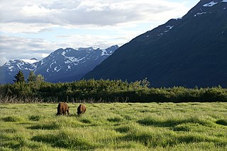
Matanuska-Susitna Valley is an area in Southcentral Alaska south of the Alaska Range about 35 miles (56 km) north of Anchorage, Alaska. It is known for the world record sized cabbages and other vegetables displayed annually in Palmer at the Alaska State Fair. It includes the valleys of the Matanuska, Knik, and Susitna Rivers. 11,000 of Mat-Su Valley residents commute to Anchorage for work . It is the fastest growing region in Alaska and includes the towns of Palmer, Wasilla, Big Lake, Houston, Willow, Sutton, and Talkeetna. The Matanuska-Susitna Valley is primarily the land of the Dena'ina and Ahtna Athabaskan people.

The Anchorage Coastal Wildlife Refuge is a wildlife refuge located in the Anchorage Municipality.
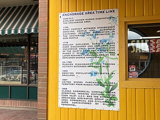
The following is a timeline of the history of the city of Anchorage, Alaska, United States.
100Stone, also known as the 100 Stone project, is a public installation art project in Alaska. It depicts "personal struggles with mental health, told in sculptural form". Sarah Davies leads the project which also includes Ed Mighell, Brian Hutton, Catherine Shenk, and Lee Holmes (engineer).

Fairview is a neighborhood in Anchorage, Alaska just east of Downtown Anchorage and west of the Merrill Field Airport. The area is a working-class neighborhood of approximately 7,200 residents, with a median household income of approximately $55,000 and a poverty rate of approximately 21%.

The trail system of Anchorage, Alaska spans 578 miles (930.2 km). The Municipality of Anchorage created the first set of trail systems for recreation in the late 1950s, not developing a system that was commuter friendly until the mid-1960s. The trails, which are used primarily for recreation and commuter traffic, are heavily utilized year round for walking, biking, and skiing. Many of the trail systems in place that connect the city of Anchorage in a commuter-friendly way were kick started by John "Jack" Roderick, the first mayor of the Municipality of Anchorage, who held office from 1972 to 1975.
References
- ↑ "7 Best Places To See The Northern Lights In Or Around Anchorage". 2021-09-04. Retrieved 2022-07-14.
- 1 2 Pesznecker, Katie (2022-04-22). "Anchorage has a terrific trail system. Here's where to start exploring" . Retrieved 2022-07-14.