
Orkney, also known as the Orkney Islands, is an archipelago in the Northern Isles of Scotland, situated off the north coast of the island of Great Britain. Orkney is 10 miles (16 km) north of the coast of Caithness and has about 70 islands, of which 20 are inhabited. The largest island, the Mainland, has an area of 523 square kilometres (202 sq mi), making it the sixth-largest Scottish island and the tenth-largest island in the British Isles. Orkney’s largest settlement, and also its administrative centre, is Kirkwall.

Hoy is an island in Orkney, Scotland, measuring 143 square kilometres (55 sq mi) – the second largest in the archipelago, after Mainland. A natural causeway, the Ayre, links the island to the smaller South Walls; the two islands are treated as one entity by the UK census.
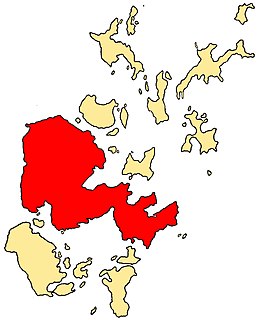
The Mainland, also known as Hrossey and Pomona, is the main island of Orkney, Scotland. Both of Orkney's burghs, Kirkwall and Stromness, lie on the island, which is also the heart of Orkney's ferry and air connections.

Stronsay is an island in Orkney, Scotland. It is known as Orkney's 'Island of Bays', owing to an irregular shape with miles of coastline, with three large bays separated by two isthmuses: St Catherine's Bay to the west, the Bay of Holland to the south and Mill Bay to the east. Stronsay is 3,275 hectares in area, and 44 metres in altitude at its highest point. It has a usually resident population of 349. The main village is Whitehall, home to a heritage centre.

Eday is one of the islands of Orkney, which are located to the north of the Scottish mainland. One of the North Isles, Eday is about 24 kilometres from the Orkney Mainland. With an area of 27 km2 (10 sq mi), it is the ninth-largest island of the archipelago. The bedrock of the island is Old Red Sandstone, which is exposed along the sea-cliffs.

Flotta is a small island in Orkney, Scotland, lying in Scapa Flow. The island is known for its large oil terminal and is linked by Orkney Ferries to Houton on the Orkney Mainland, Lyness on Hoy and Longhope on South Walls. The island has a population of 80.
South Ronaldsay is one of the Orkney Islands off the north coast of Scotland. It is linked to the Orkney Mainland by the Churchill Barriers, running via Burray, Glimps Holm and Lamb Holm.

Shapinsay is one of the Orkney Islands off the north coast of mainland Scotland. There is one village on the island, Balfour, from which roll-on/roll-off car ferries sail to Kirkwall on the Orkney Mainland. Balfour Castle, built in the Scottish Baronial style, is one of the island's most prominent features, a reminder of the Balfour family's domination of Shapinsay during the 18th and 19th centuries; the Balfours transformed life on the island by introducing new agricultural techniques. Other landmarks include a standing stone, an Iron Age broch, a souterrain and a salt-water shower.

The Northern Isles are a pair of archipelagos off the north coast of mainland Scotland, comprising Orkney and Shetland. They are part of Scotland, as are the Hebrides. The climate is cool and temperate and much influenced by the surrounding seas. There are a total of 36 inhabited islands. The landscapes of the fertile agricultural islands of Orkney contrast with the more rugged Shetland islands to the north, where the economy is more dependent on fishing and on the oil wealth of the surrounding seas. Both island groups have a developing renewable energy industry. Both have a Pictish and Norse history. Both were part of the Kingdom of Norway until they were absorbed into the Kingdom of Scotland in the 15th century. They remained part of it until the 1707 formation of the Kingdom of Great Britain and the 1801 formation of the United Kingdom. And they both played a significant naval role during the world wars of the 20th century.

Dunnet Head is a peninsula in Caithness, on the north coast of Scotland. Dunnet Head includes the most northerly point of both mainland Scotland and the island of Great Britain.
Point of Ayr is the northernmost point of mainland Wales. It is situated immediately to the north of Talacre in Flintshire, at the mouth of the Dee estuary. It is to the southwest of the Liverpool Bay area of the Irish Sea. It is the site of a RSPB nature reserve RSPB Dee Estuary Point of Ayr, and is part of Gronant and Talacre Dunes Site of Special Scientific Interest.
St Ninian's Isle is a small tied island connected by the largest tombolo in the UK to the south-western coast of the Mainland, Shetland, in Scotland. It is part of the civil parish of Dunrossness on the South Mainland. The tombolo, known locally as an ayre from the Old Norse for "gravel bank", is 500 metres long. During the summer the tombolo is above sea level and accessible to walkers. During winter, stronger wave action removes sand from the beach so that it is usually covered at high tide, and occasionally throughout the tidal cycle, until the sand is returned the following spring. Depending on the definition used, St. Ninian's is thus either an island, or a peninsula; it has an area of about 72 hectares.

The geography of Scotland is varied, from rural lowlands to unspoilt uplands, and from large cities to sparsely inhabited islands. Located in Northern Europe, Scotland comprises the northern third of the island of Great Britain as well as 790 surrounding islands encompassing the major archipelagos of the Shetland Islands, Orkney Islands and the Inner and Outer Hebrides.

South Walls, often referred to as Walls, is an inhabited island adjacent to Hoy in Orkney, Scotland. The name is a corruption of "Sooth Was", which means the "southern voes" – as with Kirkwall, it was assumed that it was a mispronunciation of "walls".

An ayre is the name used for shingle beaches found in Orkney, Shetland, the Isle of Man, Lancashire, Cumbria and Northumbria. The word is derived from the Old Norse eyrr, meaning a shingle beach or gravelly place, and may be applied to ordinary beaches, cliff-foot beaches such as the Lang Ayre in Northmavine, Shetland, spits, bars or tombolos, but only if formed of shingle. More than 130 such shingle beaches are named on Ordnance Survey maps of Shetland, but far fewer in Orkney, where most beaches are formed of sand. The word in its Old Norse form is common in Iceland, and it also occurs in a few place names in the north and west of the Scottish mainland which had a strong Norse influence, such as Eriboll and in the names of several shingle banks - Salt Ayre, Green Ayre, Stake Ayre, Rabbit Ayre and Whinny Ayre - in the tidal reach of the River Lune at Lancaster.
SHEFA-2 is an undersea communication cable linking the Faroe Islands to mainland Scotland via the Northern Isles. It is named after the route on which it is being deployed (SHEtland-FAroes) and succeeds an earlier cable called SHEFA-1 on the same route.

The geology of the Orkney islands in northern Scotland is dominated by the Devonian age Old Red Sandstone (ORS). In the southwestern part of Mainland, this sequence can be seen to rest unconformably on a Moinian type metamorphic basement.

St Magnus Bay is a large coastal feature in the north-west of Mainland Shetland, Scotland. Roughly circular in shape with a diameter of about 19 kilometres (12 mi), it is open to the North Atlantic Ocean to the west. The indented coastline to the north, south and east between Esha Ness in the north and the Ness of Melby in the south contains numerous bays, firths and voes and there are several islands around the perimeter. The waters of the bay are up to 165 metres (541 ft) deep and may have been the site of a substantial meteor impact.
Broch of Ayre, also known as St. Mary's Broch, is an Iron Age broch in Orkney, Scotland.
