Point plotting is an elementary mathematical skill required in analytic geometry. Invented by René Descartes and originally used to locate positions on militarymaps, this skill is now assumed of everyone who wants to locate grid 7A on any map.
Mathematics includes the study of such topics as quantity, structure, space, and change.
In classical mathematics, analytic geometry, also known as coordinate geometry or Cartesian geometry, is the study of geometry using a coordinate system. This contrasts with synthetic geometry.
René Descartes was a French philosopher, mathematician, and scientist. A native of the Kingdom of France, he spent about 20 years (1629–1649) of his life in the Dutch Republic after serving for a while in the Dutch States Army of Maurice of Nassau, Prince of Orange and the Stadtholder of the United Provinces. He is generally considered one of the most notable intellectual figures of the Dutch Golden Age.
In mathematics, an ordered pair is a pair of objects. The order in which the objects appear in the pair is significant: the ordered pair is different from the ordered pair unless a = b.
In mathematics, a real number is a value of a continuous quantity that can represent a distance along a line. The adjective real in this context was introduced in the 17th century by René Descartes, who distinguished between real and imaginary roots of polynomials. The real numbers include all the rational numbers, such as the integer −5 and the fraction 4/3, and all the irrational numbers, such as √2. Included within the irrationals are the transcendental numbers, such as π (3.14159265...). In addition to measuring distance, real numbers can be used to measure quantities such as time, mass, energy, velocity, and many more.
In mathematics, a bijection, bijective function, or one-to-one correspondence is a function between the elements of two sets, where each element of one set is paired with exactly one element of the other set, and each element of the other set is paired with exactly one element of the first set. There are no unpaired elements. In mathematical terms, a bijective function f: X → Y is a one-to-one (injective) and onto (surjective) mapping of a set X to a set Y.
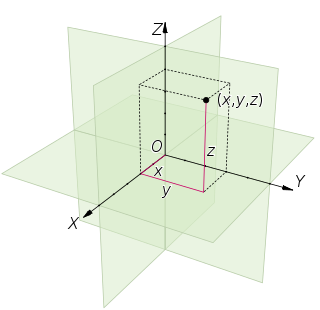
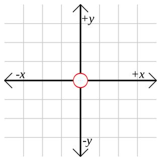
To be able to plot points, one needs to first decide on a point in plane which will be called the origin, and a couple of perpendicular lines, called the x and y axes, as well as a preferred direction on each of the lines. Usually one chooses the x axis pointing right and the y axis pointing up, and these will be named the positive directions. Also, one picks a segment in the plane which is declared to be of unit length. Using rotated versions of this segment, one can measure distances along the x and y axes.
In elementary geometry, the property of being perpendicular (perpendicularity) is the relationship between two lines which meet at a right angle. The property extends to other related geometric objects.
Having the origin and the axes in place, given a pair (x, y) of real numbers, one considers the point on the x axis at distance |x| from the origin and along the positive direction if x≥0, and the other direction otherwise. In the same way one picks the point on the y axis corresponding to the number y. The line parallel to the y axis going through the first point and the line parallel to the x axis going through the second point will intersect at precisely one point, which will be called the point with coordinates (x, y).
This page is based on this Wikipedia article Text is available under the CC BY-SA 4.0 license; additional terms may apply. Images, videos and audio are available under their respective licenses.
Related Research Articles
A Cartesian coordinate system is a coordinate system that specifies each point uniquely in a plane by a set of numerical coordinates, which are the signed distances to the point from two fixed perpendicular oriented lines, measured in the same unit of length. Each reference line is called a coordinate axis or just axis of the system, and the point where they meet is its origin, at ordered pair (0, 0). The coordinates can also be defined as the positions of the perpendicular projections of the point onto the two axes, expressed as signed distances from the origin.
In geometry, Euclidean space encompasses the two-dimensional Euclidean plane, the three-dimensional space of Euclidean geometry, and similar spaces of higher dimension. It is named after the Ancient Greek mathematician Euclid of Alexandria. The term "Euclidean" distinguishes these spaces from other types of spaces considered in modern geometry. Euclidean spaces also generalize to higher dimensions.
A geographic coordinate system is a coordinate system that enables every location on Earth to be specified by a set of numbers, letters or symbols. The coordinates are often chosen such that one of the numbers represents a vertical position and two or three of the numbers represent a horizontal position; alternatively, a geographic position may be expressed in a combined three-dimensional Cartesian vector.
A common choice of coordinates is latitude, longitude and elevation.
To specify a location on a plane requires a map projection.
In geometry, a coordinate system is a system that uses one or more numbers, or coordinates, to uniquely determine the position of the points or other geometric elements on a manifold such as Euclidean space. The order of the coordinates is significant, and they are sometimes identified by their position in an ordered tuple and sometimes by a letter, as in "the x-coordinate". The coordinates are taken to be real numbers in elementary mathematics, but may be complex numbers or elements of a more abstract system such as a commutative ring. The use of a coordinate system allows problems in geometry to be translated into problems about numbers and vice versa; this is the basis of analytic geometry.
In mathematics, the complex plane or z-plane is a geometric representation of the complex numbers established by the real axis and the perpendicular imaginary axis. It can be thought of as a modified Cartesian plane, with the real part of a complex number represented by a displacement along the x-axis, and the imaginary part by a displacement along the y-axis.
In mathematics, homogeneous coordinates or projective coordinates, introduced by August Ferdinand Möbius in his 1827 work Der barycentrischeCalcül, are a system of coordinates used in projective geometry, as Cartesian coordinates are used in Euclidean geometry. They have the advantage that the coordinates of points, including points at infinity, can be represented using finite coordinates. Formulas involving homogeneous coordinates are often simpler and more symmetric than their Cartesian counterparts. Homogeneous coordinates have a range of applications, including computer graphics and 3D computer vision, where they allow affine transformations and, in general, projective transformations to be easily represented by a matrix.
In basic mathematics, a number line is a picture of a graduated straight line that serves as abstraction for real numbers, denoted by
. Every point of a number line is assumed to correspond to a real number, and every real number to a point.
In mathematics, the real projective plane is an example of a compact non-orientable two-dimensional manifold; in other words, a one-sided surface. It cannot be embedded in standard three-dimensional space without intersecting itself. It has basic applications to geometry, since the common construction of the real projective plane is as the space of lines in R3 passing through the origin.
A vanishing point is a point on the image plane of a perspective drawing where the two-dimensional perspective projections of mutually parallel lines in three-dimensional space appear to converge. When the set of parallel lines is perpendicular to a picture plane, the construction is known as one-point perspective, and their vanishing point corresponds to the oculus, or "eye point", from which the image should be viewed for correct perspective geometry. Traditional linear drawings use objects with one to three sets of parallels, defining one to three vanishing points.
In plane geometry, a shear mapping is a linear map that displaces each point in fixed direction, by an amount proportional to its signed distance from the line that is parallel to that direction and goes through the origin. This type of mapping is also called shear transformation, transvection, or just shearing.
In mathematics, the origin of a Euclidean space is a special point, usually denoted by the letter O, used as a fixed point of reference for the geometry of the surrounding space.
In classical geometry, a radius of a circle or sphere is any of the line segments from its center to its perimeter, and in more modern usage, it is also their length. The name comes from the Latin radius, meaning ray but also the spoke of a chariot wheel. The plural of radius can be either radii or the conventional English plural radiuses. The typical abbreviation and mathematical variable name for radius is r. By extension, the diameter d is defined as twice the radius:
Three-dimensional space is a geometric setting in which three values are required to determine the position of an element. This is the informal meaning of the term dimension.
A two-dimensional graph is a set of points in two-dimensional space. If the points are real and if Cartesian coordinates are used, each axis depicts the potential values of a particular real variable. Often the variable on the horizontal axis is called x and the one on the vertical axis is called y, in which case the horizontal and vertical axes are sometimes called the x axis and y axis respectively. With real variables on the axes, each point in the graph depicts the values of two real variables.
Two-dimensional space is a geometric setting in which two values are required to determine the position of an element. In mathematics, it is commonly represented by the symbol ℝ2. For a generalization of the concept, see dimension.
In mathematics, a conic section is a curve obtained as the intersection of the surface of a cone with a plane. The three types of conic section are the hyperbola, the parabola, and the ellipse. The circle is a special case of the ellipse, and is of sufficient interest in its own right that it was sometimes called a fourth type of conic section. The conic sections have been studied by the ancient Greek mathematicians with this work culminating around 200 BC, when Apollonius of Perga undertook a systematic study of their properties.
In mathematics, a translation of axes in two dimensions is a mapping from an xy-Cartesian coordinate system to an x'y'-Cartesian coordinate system in which the x' axis is parallel to the x axis and k units away, and the y' axis is parallel to the y axis and h units away. This means that the origin O' of the new coordinate system has coordinates in the original system. The positive x' and y' directions are taken to be the same as the positive x and y directions. A point P has coordinates with respect to the original system and coordinates with respect to the new system, where
In the hyperbolic plane, as in the Euclidean plane, each point can be uniquely identified by two real numbers. Several qualitatively different ways of coordinatizing the plane in hyperbolic geometry are used.