Higashichikuma is a district located in Nagano Prefecture, Japan.

Jankovice is a village in the Pardubice Region of the Czech Republic. It has around 300 inhabitants.
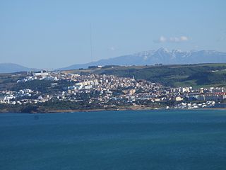
La Goulette is the port of Tunis, the capital of Tunisia. The Kasbah fortress was built in 1535 by Charles I of Spain but was captured by the Ottoman Turks in 1574. La Goulette is located at around 36°49′5″N10°18′18″E.

The Karachi Metropolitan Corporation (KMC) Building is a historic building located at M. A. Jinnah road in Karachi. The foundation stone for the building was laid in 1927, construction was completed in 1930, and it was inaugurated in 1932.

Kavadarci is a municipality in the southern part of the Republic of Macedonia. Kavadarci is also the name of the town where the municipal seat is found. Kavadarci Municipality is part of the Vardar Statistical Region.

Szczecin is a village in the administrative district of Gmina Chodecz, within Włocławek County, Kuyavian-Pomeranian Voivodeship, in north-central Poland. It lies approximately 5 kilometres (3 mi) south of Chodecz, 33 km (21 mi) south of Włocławek, and 80 km (50 mi) south of Toruń.
Bielawy is a village in the administrative district of Gmina Barcin, within Żnin County, Kuyavian-Pomeranian Voivodeship, in north-central Poland. It lies approximately 5 kilometres (3 mi) east of Barcin, 21 km (13 mi) east of Żnin, and 32 km (20 mi) south of Bydgoszcz.
Raczynów is a village in the administrative district of Gmina Widawa, within Łask County, Łódź Voivodeship, in central Poland. It lies approximately 11 kilometres (7 mi) south-east of Widawa, 28 km (17 mi) south of Łask, and 58 km (36 mi) south-west of the regional capital Łódź.

Şüşün is a village and municipality in the Kurdamir Rayon of Azerbaijan.
Nowa Wieś is a village in the administrative district of Gmina Wartkowice, within Poddębice County, Łódź Voivodeship, in central Poland. It lies approximately 6 kilometres (4 mi) south of Wartkowice, 5 km (3 mi) north-east of Poddębice, and 36 km (22 mi) north-west of the regional capital Łódź.
Michałów is a village in the administrative district of Gmina Zduńska Wola, within Zduńska Wola County, Łódź Voivodeship, in central Poland. It lies approximately 4 kilometres (2 mi) east of Zduńska Wola and 38 km (24 mi) south-west of the regional capital Łódź.
Szczyty is a village in the administrative district of Gmina Białobrzegi, within Białobrzegi County, Masovian Voivodeship, in east-central Poland. It lies approximately 5 kilometres (3 mi) east of Białobrzegi and 64 km (40 mi) south of Warsaw.
Gökdepe District is a district of Ahal Region in Turkmenistan.
Weśrednik is a village in the administrative district of Gmina Szamocin, within Chodzież County, Greater Poland Voivodeship, in west-central Poland. It lies approximately 6 kilometres (4 mi) south-west of Szamocin, 11 km (7 mi) east of Chodzież, and 69 km (43 mi) north of the regional capital Poznań.

Locwood is an MTR Light Rail stop. It is located at ground level at Tin Shui Road, between Locwood Court and Sherwood Court of Kingswood Villas, in Tin Shui Wai, Yuen Long District. It began service on 10 January 1993 and belongs to Zone 4.
Cienin Kościelny is a village in the administrative district of Gmina Słupca, within Słupca County, Greater Poland Voivodeship, in west-central Poland.
Strzałkowo is a village in Słupca County, Greater Poland Voivodeship, in west-central Poland. It is the seat of the gmina called Gmina Strzałkowo. It lies approximately 4 kilometres (2 mi) west of Słupca and 63 km (39 mi) east of the regional capital Poznań.
Mbalal or M'Balel is a town and urban commune in the Trarza Region of south-western Mauritania.
Popowo is a village in the administrative district of Gmina Będzino, within Koszalin County, West Pomeranian Voivodeship, in north-western Poland. It lies approximately 4 kilometres (2 mi) south of Będzino, 12 km (7 mi) west of Koszalin, and 127 km (79 mi) north-east of the regional capital Szczecin.

Badince is a village in the municipality of Leskovac, Serbia. According to the 2002 census, the village has a population of 521 people.