Pointe de la Fournache

Last updated
Pointe de la Fournache

Dent Parrachee 02 by Line1.jpg

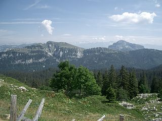
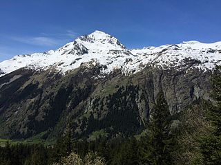
Southern face of Pointe de la Fournache (left) and Dent Parrachée (right) in the background, separated by a small cirque glacier
Highest point
Elevation 3,642 m (11,949 ft)
Coordinates 45°17′15″N06°45′09″E / 45.28750°N 6.75250°E / 45.28750; 6.75250 Coordinates: 45°17′15″N06°45′09″E / 45.28750°N 6.75250°E / 45.28750; 6.75250
Geography
France relief location map.jpg
Red triangle with thick white border.svg
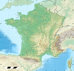
Pointe de la Fournache
France
Location Savoie, France
Parent range Vanoise Massif
Geology
Age of rock Early Jurassic
Mountain type limestone

Pointe de la Fournache is a mountain of Savoie, France. It lies in the Massif de la Vanoise range. It has an elevation of 3,642 metres (11,949 ft) above sea level.

Savoie Department of France in Auvergne-Rhône-Alpes

Savoie is a department in the Auvergne-Rhône-Alpes region of France. Its prefecture is Chambéry; it is located in the French Alps. In 2016, it had a population of 429,681.

France Republic with mainland in Europe and numerous oversea territories

France, officially the French Republic, is a country whose territory consists of metropolitan France in Western Europe and several overseas regions and territories. The metropolitan area of France extends from the Mediterranean Sea to the English Channel and the North Sea, and from the Rhine to the Atlantic Ocean. It is bordered by Belgium, Luxembourg and Germany to the northeast, Switzerland and Italy to the east, and Andorra and Spain to the south. The overseas territories include French Guiana in South America and several islands in the Atlantic, Pacific and Indian oceans. The country's 18 integral regions span a combined area of 643,801 square kilometres (248,573 sq mi) and a total population of 67.3 million. France, a sovereign state, is a unitary semi-presidential republic with its capital in Paris, the country's largest city and main cultural and commercial centre. Other major urban areas include Lyon, Marseille, Toulouse, Bordeaux, Lille and Nice.

Pointe de la Fournache lies north of Aussois and southwest of Dent Parrachée (3,697 metres (12,129 ft)). The summit is very close to Dent Parrachée, which is separated by a short ridge.

Aussois Commune in Auvergne-Rhône-Alpes, France

Aussois is a commune in the Vanoise massif, in the Savoie department in the Auvergne-Rhône-Alpes region in south-eastern France. The village is on the border of France's first National Park, the Vanoise National Park.
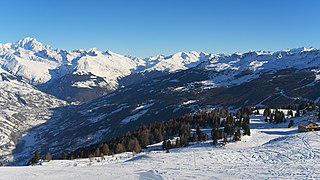
Although not as well known as other resorts right on the other side of the mountain like Val Thorens, it is popular with the French as ski resort in winter and as mountain destination in summer.
At 8 km (5.0 mi) from Modane, it is ideally located in the Maurienne region with good transport links in and out of Lyon, Geneva, Grenoble and Chambéry. Aussois can also be reached from Turin via the Fréjus Road Tunnel, linking Bardonecchia in Italy and Modane.
Nearby Gare de Modane is a large railway station with a high-speed service (TGV) Paris - Chambéry - Turin - Milan.
The resort offers 55 km (34 mi) of slopes, 21 slopes.

Dent Parrachée mountain

Dent Parrachée is a mountain of Savoie, France. It lies in the Massif de la Vanoise range. It has an elevation of 3,697 metres above sea level.

Related Research Articles

Albertville Subprefecture and commune in Auvergne-Rhône-Alpes, France

Albertville is a commune in the Savoie department in the Auvergne-Rhône-Alpes region in south-eastern France.

Chartreuse Mountains mountains in France

The Chartreuse Mountains is a mountain range in southeastern France, stretching from the city of Grenoble in the south to the Lac du Bourget in the north. It is part of the French Prealps, which continue as the Bauges to the north and the Vercors to the south.

Dent Blanche mountain in the Pennine Alps

The Dent Blanche is a mountain in the Pennine Alps, lying in the canton of Valais in Switzerland. With its 4,357 metres (14,295 ft)-high summit, it is one of the highest peaks in the Alps.

Bauges mountain range

The Bauges Mountains is a mountain range in eastern France, stretching from the city of Annecy to the city of Chambéry, which is part of the French Prealps.

Bertol Hut

The Bertol Hut is a mountain hut overlooking the Bertol Pass, south of Arolla in the Swiss canton of Valais. It is known for its precarious position on a ridge at 3,311 metres (10,863 ft) south of the Pointe de Bertol and is accessed by a number of fixed ladders and chains from the glacier pass. All accesses to the hut involve glacier crossing. On its east side it overlooks the large plateau of the Mont Miné Glacier.

Dents du Midi mountain in Switzerland

The Dents du Midi are a multi-summited mountain situated in the Chablais Alps in the Swiss canton of Valais. They are composed of seven distinct summits and reach a height of 3257 metres. Highest mountain between Lake Geneva and the Mont Blanc Massif, they dominate the Val-d'Illiez and the Rhône Valley, from Martigny down to the lake. Together with the slightly lower Tour Sallière, they form a cirque around the Lac de Salanfe, an artificial reservoir. Geologically it makes up a part of the massif Haut-Giffre.

Modane Commune in Auvergne-Rhône-Alpes, France

Modane is a commune in the Savoie department in the Auvergne-Rhône-Alpes region in southeastern France.

Dent du Géant mountain in the Mont Blanc Massif in the Alps

The Dent du Géant is a mountain in the Mont Blanc massif in France and Italy.

Isabella Charlet-Straton British mountain climber

Mary Isabella Charlet-Straton was a British female mountain climber. She made several first ascents in the Alps with Emmeline Lewis Lloyd as well as the first winter ascent of Mont Blanc with her future husband Jean Charlet in January 1876. The peak Pointe Isabella was named in her honour after she had taken part in its first ascent.

Vanoise massif mountains in France

The Vanoise massif is a mountain range of the Graian Alps, located in the Western Alps. After the Mont Blanc Massif and the Massif des Écrins it is the third highest massif in France, reaching a height of 3,885m at the summit of Grande Casse. It lies between Tarentaise Valley to the north and the Maurienne valley in the south. The range is the site of France's first National Park in 1963, the Vanoise National Park. The ski resorts of Tignes and Val-d'Isère and the 2,770m high Col de l'Iseran are located in the eastern part of the range.

Aiguille de la Tsa mountain

The Aiguille de la Tsa is a mountain of the Swiss Pennine Alps, overlooking Arolla in the canton of Valais. It lies on the range culminating at the Dent de Perroc, between the valley of Arolla and the Mont Miné Glacier.

Phare de lEspiguette lighthouse in Gard, France

The Phare de l'Espiguette is a 27-metre (89 ft)-high square tower. Built in 1869, the lighthouse is found on the Pointe de l'Espiguette, near to Le Grau-du-Roi on the Gulf of Lion in Languedoc-Roussillon, France.

Pointe des Genevois mountain

The Pointe des Genevois is a mountain of the Swiss Pennine Alps, overlooking Arolla in the canton of Valais. It lies just south of the higher summit of the Dent de Perroc.

Dent de Crolles mountain

The Dent de Crolles is a karstic mountain of the Chartreuse Mountains range, 17 kilometres north east of Grenoble, Isère, France. It has a characteristic "tooth-like" profile and is easily recognizable in the Isère Valley (Grésivaudan) in the Grenoble area. Its name is derived from the town of Crolles, located next to the mountain.

Refuge de la Dent Parrachée building

Refuge de la Dent Parrachée is a refuge of Savoie, France. It lies in the Massif de la Vanoise range. It has an altitude of 2511 metres above sea level.

Refuge de la Fournache

Refuge de la Fournache is a refuge of Savoie, France. It lies in the Massif de la Vanoise range. It has an altitude of 2330 metres above sea level.

Torino Hut italian mountain hut

The Torino Hut is a high mountain refuge in the Alps in northwestern Italy. Located near the border with France, it is about 15 km (10 mi) southwest of Mont Dolent, the tripoint with Switzerland. The refuge is in the Mont Blanc massif above the town of Courmayeur in the Aosta Valley, Italy. It can be most easily accessed from the Italian side by the Skyway Monte Bianco cable car from La Palud in Courmayeur, with a change at the Pavilion du Mont Fréty. It can also be reached from Chamonix via the Aiguille du Midi, either by cable car which crosses the massif, or by a long crossing of the Glacier du Gèant. The refuge lies nearly directly above the 11.6 km (7.2 mi) Mont Blanc Tunnel, which passes deep underground, and connects Courmayer to Chamonix.

Phare de Gatteville lighthouse in Manche, France

Phare de Gatteville, also known as Pointe de Barfleur Light, is an active lighthouse near Gatteville-le-Phare at the tip of Barfleur, Manche department, in the Lower Normandy region of France. At a height of 247 feet (75 m) it is the third tallest "traditional lighthouse" in the world.

Arcalod mountain

Arcalod is a mountain of Savoie, France. It lies in the Bauges range of the French Prealps and has an elevation of 2,217 metres (7,274 ft) above sea level.

Acul Bay, also known as North Acul Bay, is a bay on the northern coast of Haiti north of the city of Acul-du-Nord and west of the city of Cap-Haïtien.

References