As part of the Upper Harz Water Regale it was built in the 18th century and was used to lift the water needed in Clausthal for the mining industry from the Dyke Ditch (Dammgraben) to the level of the highest pond, the Hirschler Pond. Aside from this water hoist, the Dyke Ditch supplied, and still supplies, water over ditches and tunnels to the Hausherzberg Ponds and the Lower Peacock Pond (Unterer Pfauenteich). The problem was however, that, as it happened, the most productive silver mines in the Upper Harz mining region, the Caroline Pit and the Dorothea Pit, were high up in the mountains and could only be supplied with water power from the Hirschler Pond.
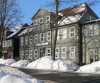
The motive force for the wooden piston pumps was won in the Polster valley below by two water wheels. The headrace for these water wheels was brought via the Heller Valley Ditch (Hellertal Graben) from the Heller valley and from the Fortune Pond over its Bottom Ditch (Grundgraben), but frictional losses and poor efficiencies meant that a considerable amount of headrace water was required in order to lift just a few litres of water from the Dyke Ditch. These wheels transferred their output power over 260and 560m long flat rods made of wood to the pumping station on the Polsterberg hill. In the pumping station the water from the Dyke Ditch was pumped 8m higher and fed into drinking troughs from which it was then further transported via the Hutthal Ditch and Huttaler Widerwaage to the Hirschler Pond, or via the Jägersbleek Tunnel and Ditch. The Polsterberg Pumphouse also acted as living accommodation for the master pumper and the ditch keepers, as well as a bar (Schankstube).
At the beginning of the 20th century the wooden structures were replaced by electrically-drive pumps; the original can still be seen in the pumphouse by the ditch. Today the building is listed. It is purely run as a restaurant and is a popular destination for walkers from Altenau and Clausthal-Zellerfeld. Like the nearby Sperberhai Dam House it lies on the Harz High Road, the B 242.
Clausthal-Zellerfeld is a town in Lower Saxony, Germany. It is located in the southwestern part of the Harz mountains. Its population is approximately 15,000. The town hosts the Clausthal University of Technology. The health resort is located in the Upper Harz at an altitude between 390 and 821 m above sea level.
Altenau ( ) is a town and a former municipality in the district of Goslar, in Lower Saxony, Germany. Since 1 January 2015 it is part of the town Clausthal-Zellerfeld.
The Upper Harz Mining Museum is a museum of technological and cultural history in Clausthal-Zellerfeld in the Harz mountains of central Germany. It is one of the oldest technological museums in Germany and concentrates on the history and presentation of mining in the Upper Harz up to the 19th century.
The Upper Harz Ditches are hillside ditches, running roughly parallel to the contour lines, that were laid out in the Upper Harz in Germany from the 16th to the 19th centuries to supply water power to the silver mines there. They are an important component of the Upper Harz Water Regale, a historical water system that is now a cultural monument.
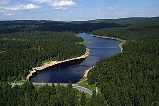
The Oderteich is an historic reservoir about seven kilometres northeast of Sankt Andreasberg in the Upper Harz in central Germany. It was built by miners from St. Andreasberg in the years 1715 to 1722 and, today, is an important component of the water supply network known as the Upper Harz Water Regale. Moreover, for 170 years, from the time it was completed to the end of the 19th century, the Oderteich had the largest dam in Germany. The dam lies at a height of 725 m above NN by the B 242 federal highway, about a kilometre west of its intersection with the B 4.
The Upper Harz Water Tunnels are part of the Upper Harz Water Regale - a network of reservoirs, ditches, tunnels and other structures in the Harz mountains of central Germany. The German term Wasserlauf refers to the underground element of the network of watercourses used in the historic silver mining industry of the Upper Harz. This network of ditches and tunnels was used to supply the mines with headrace waters for their water wheels from the 16th century onwards. In the system of the Upper Harz Water Regale there are over 35 such tunnels with a total length of about 30 km (19 mi).
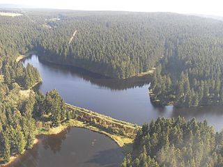
The Upper Harz Ponds are found mainly around the mining town of Clausthal-Zellerfeld and the nearby villages of Buntenbock and Hahnenklee in the Upper Harz mountains of central Germany. There are around 70 ponds in total, both large and small. They were built by the miners of the Upper Harz, mostly between the 16th and 18th centuries, and are important components of the cultural monument known as the Upper Harz Water Regale - a network of dams, ditches, ponds and tunnels that was built to supply much-needed water power for the mining industry in the Harz mountains. Today the Water Regale is being proposed as a UNESCO World Heritage Site. About half the dammed ponds are classified today as reservoirs, but they have now become characteristic features of the Upper Harz and are home to some extremely rare plant and animal species.
The Polster Valley Wheel House lies in the Polster valley about three kilometres from Altenau in the Upper Harz region of Germany and is surrounded by a campsite.
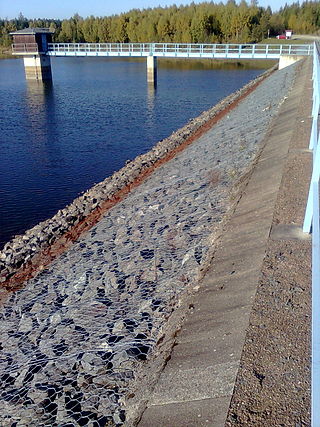
The Dyke Ditch is the longest artificial ditch in the Upper Harz in central Germany. Its purpose was to collect surface runoff for the operation of the Upper Harz mining industry from precipitation-heavy regions a long way away. It was laid in 1732 and continually extended eastwards until 1827. Its original length was about 25 km; this was successively shortened by water tunnels between 1820 and 1861 to around 19 km. It is a central component of the Upper Harz Water Regale. Its takes its name from the Sperberhai Dyke which is, in fact, an embankment on top of which the Dyke Ditch runs in an aqueduct in order to cross a depression.
The Sperberhai Dyke is in fact an aqueduct which forms part of the Upper Harz Water Regale network of reservoirs, ditches, dams and tunnels in the Harz mountains of central Germany. It carries the water of the Dyke Ditch over the depression of the Sperberhai to the Clausthal plateau.
The Harz Witches' Trail is a footpath, just under 100 km long, in Germany that runs from Osterode through the Harz mountains and over its highest peak, the Brocken, to Thale. It is a project by the Harz Transport Association and Harz Club and is part of the system of trails known as the Harzer Wandernadel.
The Upper Harz Water Regale is a system of dams, reservoirs, ditches and other structures, much of which was built from the 16th to 19th centuries to divert and store the water that drove the water wheels of the mines in the Upper Harz region of Germany. The term regale, here, refers to the granting of royal privileges or rights in this case to permit the use of water for mining operations in the Harz mountains of Germany.
Mining in the Upper Harz region of central Germany was a major industry for several centuries, especially for the production of silver, lead, copper, and, latterly, zinc as well. Great wealth was accumulated from the mining of silver from the 16th to the 19th centuries, as well as from important technical inventions. The centre of the mining industry was the group of seven Upper Harz mining towns of Clausthal, Zellerfeld, Sankt Andreasberg, Wildemann, Grund, Lautenthal und Altenau.
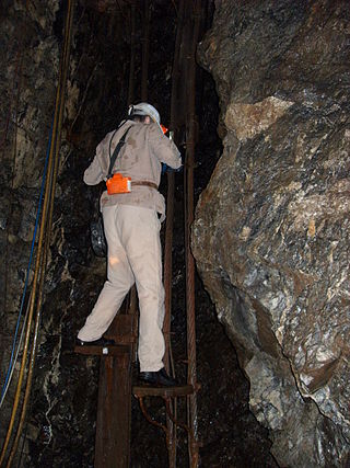
The Samson Pit or Samson Mine is an historic silver mine in Sankt Andreasberg in the Upper Harz region of central Germany.
A Kunstteich is an historic German term for a man-made lake or pond associated with the mining industry and its technology. These ponds were created by the construction of barriers, typically dams and embankments, and were used to supply hydropower and water to the mines. Water stored in the reservoir was used for a variety of purposes. It was used to turn water wheels that in turn drove the various mechanical devices used in mining in earlier centuries, such as man engines. It was also used to produce power and drain the mines, or in the processing of ore. In principle, all Kunstteiche are small dam and reservoir installations. The oldest working dams in Germany are Kunstteiche.
A Kunstgraben is a type of man-made water channel that was once used by mines to drive the water wheels needed for power, mine drainage and a host of other purposes. The term is German. Similar ditches supplying water mills in England are called leats.
The Kiliansteich is one of the oldest reservoirs in Germany. The reservoir is located near Straßberg (Harz) in the German state of Saxony-Anhalt and supplies drinking water. It impounds the Büschengraben stream. The lake is part of the heritage area (Flächendenkmal) of the Lower Harz Pond and Ditch System.
Within the Lower Harz region are still many traces of the historical water management facilities used by the mining industry. In addition to water-carrying ditches and ponds, there are also long-abandoned ditches and dry pond beds. The Lower Harz Pond and Ditch System, which forms the major part of these old water management facilities, lies in the central Lower Harz, almost entirely within the borough of the present-day town of Harzgerode.
The Huttaler Widerwaage is a small reservoir that is a part of the Upper Harz Water Regale, an old mining water management system in the Harz Mountains of Germany that is now a UNESCO World Heritage Site. The reservoir lies east of the mining town of Clausthal-Zellerfeld. It is designed to feed water from the Huttal river during times of low water to the reservoir pond of the Hirschler Teich and, during times of high water, to handle the overflow of water from it.
The Bärenbrucher Teich is an historic reservoir in the Harz Mountains of central Germany. It lies east of Buntenbock near Clausthal-Zellerfeld.
This page is based on this Wikipedia article Text is available under the CC BY-SA 4.0 license; additional terms may apply. Images, videos and audio are available under their respective licenses.