| Pometenik | |
|---|---|
| Highest point | |
| Elevation | 703 m (2,306 ft) |
| Coordinates | 43°28′26″N17°48′20″E / 43.47389°N 17.80556°E Coordinates: 43°28′26″N17°48′20″E / 43.47389°N 17.80556°E |
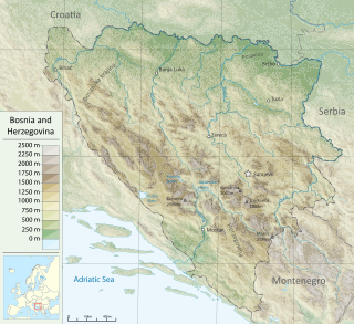
Pometenik is a mountain in Bosnia and Herzegovina.
| Pometenik | |
|---|---|
| Highest point | |
| Elevation | 703 m (2,306 ft) |
| Coordinates | 43°28′26″N17°48′20″E / 43.47389°N 17.80556°E Coordinates: 43°28′26″N17°48′20″E / 43.47389°N 17.80556°E |
Pometenik is a mountain in Bosnia and Herzegovina.
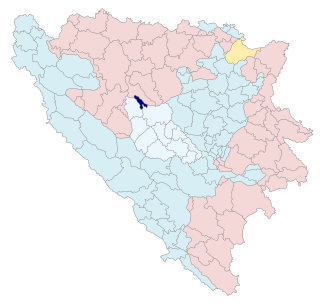
It is located near the city of Mostar.
The mountain's highest peak has an elevation of 703 metres (2,306 ft) above sea level.

Bosnia and Herzegovina, abbreviated BiH or B&H, sometimes called Bosnia–Herzegovina and often known informally as Bosnia, is a country at the crossroads of south and southeast Europe, located in the Balkans. The capital and largest city is Sarajevo. Bosnia and Herzegovina borders Serbia to the east, Montenegro to the southeast, and Croatia to the north and southwest. It is not entirely landlocked; in the south it has a narrow coast on the Adriatic Sea within the Mediterranean, which is about 20 kilometres long and surrounds the town of Neum. Bosnia, which is the inland region of the country, has a moderate continental climate with hot summers and cold, snowy winters. In the central and eastern regions of the country, the geography is mountainous, in the northwest it is moderately hilly, and in the northeast it is predominantly flat. Herzegovina, which is the smaller, southern region of the country, has a Mediterranean climate and is mostly mountainous.
Bosnia and Herzegovina is located in Southeastern Europe, in the western Balkans. It has a 932 km (579 mi) border with Croatia to the north and southwest, a 357 km (222 mi) border with Serbia to the east, and a 249 km (155 mi) border with Montenegro to the southeast. It borders the Adriatic Sea along its 20 km (12 mi) coastline.

Sarajevo is the capital and largest city of Bosnia and Herzegovina, with a population of 275,569 in its administrative limits. The Sarajevo metropolitan area including Sarajevo Canton, East Sarajevo and nearby municipalities is home to 555,210 inhabitants. Located within the greater Sarajevo valley of Bosnia, it is surrounded by the Dinaric Alps and situated along the Miljacka River in the heart of the Balkans, a region of Southern Europe.

The General Framework Agreement for Peace in Bosnia and Herzegovina, also known as the Dayton Agreement or the Dayton Accords, is the peace agreement reached at Wright-Patterson Air Force Base near Dayton, Ohio, United States, on 21 November 1995, and formally signed in Paris, on 14 December 1995. These accords put an end to the three-and-a-half-year-long Bosnian War, one of the Yugoslav Wars.


The Posavina Canton is one of ten cantons of the Federation of Bosnia and Herzegovina in Bosnia and Herzegovina. It is the smallest canton with an area of only 330.85 km2 (128 sq mi). The canton is an exclave of Federation of Bosnia and Herzegovina, being bordered by Republika Srpska and Brčko District to the south and the river Sava and Croatia to the north. Its capital is Orašje and the largest town is Odžak.

Travnik is a town and a municipality in Bosnia and Herzegovina. It is the administrative center of Central Bosnia Canton of the Federation of Bosnia and Herzegovina. It is situated in central Bosnia and Herzegovina, 90 kilometres west of Sarajevo. As of 2013, the town had a population of 15,344 inhabitants, while the municipality had 53,482 inhabitants.
The Sarajevo Canton, officially the Canton of Sarajevo is one of 10 cantons of the Federation of Bosnia and Herzegovina in Bosnia and Herzegovina. Its cantonal seat is the city of Sarajevo, also the capital city of Bosnia and Herzegovina.
The West Herzegovina Canton is one of the cantons of the Federation of Bosnia and Herzegovina. The West Herzegovina Canton is in the Herzegovina region in the southwest of Bosnia and Herzegovina. Its seat of government is in Široki Brijeg, while other municipalities within the Canton are Grude, Ljubuški and Posušje. It has 94,898 inhabitants, of whom more than 98% are ethnic Croats.

Bosanska Krajina is a geographical region, a subregion of Bosnia, in western Bosnia and Herzegovina. It is enclosed by a number of rivers, namely the Sava (north), Glina (northwest), Vrbanja and Vrbas. The region is also a historic, economic and cultural entity of Bosnia and Herzegovina, famous for its natural beauties and wildlife diversity.
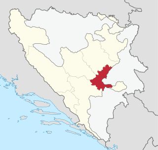
Jablanica (Јабланица) is a town and municipality located in Herzegovina-Neretva Canton of the Federation of Bosnia and Herzegovina, an entity of Bosnia and Herzegovina. It is situated on the Neretva river and Jablanica lake.

Bosnia is the northern region of Bosnia and Herzegovina, encompassing roughly 81% of the country; the other region, the southern part, is Herzegovina.

Banovići is a town and municipality located in Tuzla Canton of the Federation of Bosnia and Herzegovina, an entity of Bosnia and Herzegovina. It is located in northeastern Bosnia and Herzegovina. The intensive development of Banovići began with the construction of the railway Brčko-Banovići in the year 1946. Due to its quality, brown coal from Banovići is well-known all over Europe.
Dobretići is a village and municipality located in Central Bosnia Canton of the Federation of Bosnia and Herzegovina, an entity of Bosnia and Herzegovina. It is one of the youngest and smallest municipalities in Bosnia and Herzegovina hence being one of the poorest municipalities as well. Before the Bosnian War municipality of Dobretići was part of municipality Skender Vakuf.

The Drina is a 346 km (215 mi) long Balkans river, which forms a large portion of the border between Bosnia and Herzegovina and Serbia. It is the longest tributary of the Sava River and the longest karst river in the Dinaric Alps which belongs to the Danube river watershed. Its name is derived from the Roman name of the river which in turn is derived from Greek.

Herzegovina is the southern and smaller of two main geographical regions of Bosnia and Herzegovina, the other being Bosnia. It has never had strictly defined geographical or cultural-historical borders, nor has it ever been defined as an administrative whole in the geopolitical and economic subdivision of Bosnia and Herzegovina.

The environment of Bosnia and Herzegovina consists of diverse climates, flora and fauna, natural landmarks and landscapes. The climate ranges from continental, oceanic, subtropical and Mediterranean throughout different regions of the country. Most of the Dinaric Alps are located in Bosnia and Herzegovina, the highest elevation point is the mountain Maglic at 2,386 (7,828 ft), while the lowest point of elevation is the Adriatic Sea in the South of the country. 42.8% of the land is covered in thick forests. The country is rich in water resources, and in certain places, rivers and springs may be used without previous filtration. Significant rivers are the Drina, Neretva, Sava, Bosna and Una. Important national parks include Kozara National Park, Sutjeska National Park, and Una National Park, all nationally protected areas.

Kraljeva Sutjeska, sometimes Kraljevska Sutjeska, or just Sutjeska or Sutiska, historically Trstivnica after the river Trstionica that flows through it, in local tradition Naše stolno misto, is a village in the municipality of Kakanj, Bosnia and Herzegovina. The village has historical significance and rich heritage. During the Middle Ages it use to be a capital of medieval Bosnian state, and a place where the main court of the royal Bosnian Kotromanić dynasty was situated. The town was also called Trstivnica in official state charters of that time. It is situated at the foothills of Zvijezda mountain. A couple of kilometres above the Sutjeska, in northeastern direction in the mountain, the historic fortress-city of Bobovac was situated, which was also a secluded royal seat of the Bosnian kings.
| | This Herzegovina-Neretva Canton geography article is a stub. You can help Wikipedia by expanding it. |