Pomme de Terre, Minnesota

Last updated

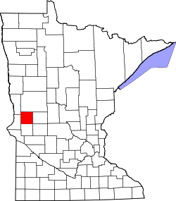
Pomme de Terre is an extinct town in section 24 of Pomme de Terre Township in Grant County, Minnesota, United States. [1] Content referring to Fort Pomme de Terre or the stockade have been removed as they were not at the same location. The fort site was located about 1 1/2 miles east of the village site.

Contents

History

The town was located next to the Pomme de Terre River. Pomme de Terre River Appleton.jpg
The town was located next to the Pomme de Terre River.
platmap Pomme de Terre plat.jpg
platmap

Pomme de Terre was the first village settled in Grant County in 1868. It was settled by Timothy Heald, Joseph Pennock and Frank Smith and platted in 1874 by Timothy Heald in section 24 of Pomme de Terre Township. The site was chosen for its location of where the stagecoach road from St. Cloud, Minnesota to Fort Abercrombie (on the Red River) crossed the Pomme de Terre River. [2]

Illustration of the Fort Pomme de Terre Stockade. From the publication, "Inventory of County Archives of Minnesota" Grant County. POMME DE TERRE STOCKADE-Grant County-cropped--Cover, Inventory of County Archives of Minnesota.jpg
Illustration of the Fort Pomme de Terre Stockade. From the publication, "Inventory of County Archives of Minnesota" Grant County.

In 1871, N.Q. Puntches moved his general merchandise stock from the old stockade (Fort Pomme de Terre, located about 1 1/2 miles to the east) to the village. Frank Williams and August Schaeffer built a grist mill in 1873. [2] The grist mill burned down in August 1887. At the time the mill was shipping out three carloads of flour each week. [3]

A post office existed during the years 1868-79, and 1880 to 1902. [1] At its height, Pomme de Terre had two stores, two blacksmith shops, a grist mill, elevator, hotel and saloon.

In April 1873, the first county commissioners for Grant County, Henry F. Sanford, K.N.O. Melby and S.S. Frogner, met in N.Q. Puntches store for the purpose of choosing the county seat. A motion to locate the county seat at Pomme de Terre failed. [2] It was instead located at what is now Elbow Lake. The development of Herman, the growth of Elbow Lake as the county seat, and the failure of the railroad to come through Pomme de Terre (going instead to the north through Ashby) led to the eventual demise of the village.
Etymology

The name Pomme de Terre is French and is translated as "apple of the earth," which usually refers to the potato. In this case, however, it refers to the prairie turnip (Psoralea esculenta), [1] a potato-like root vegetable which was commonly eaten by the Sioux.

Related Research Articles

<span class="mw-page-title-main">Fort Dearborn</span> Historic fort built at site of Chicago, Illinois, USA

Fort Dearborn was a United States fort, first built in 1803 beside the Chicago River, in what is now Chicago, Illinois. It was constructed by U.S. troops under Captain John Whistler and named in honor of Henry Dearborn, then United States Secretary of War. The original fort was destroyed following the Battle of Fort Dearborn during the War of 1812, and a replacement Fort Dearborn was constructed on the same site in 1816 and decommissioned by 1837.

<span class="mw-page-title-main">Stevens County, Minnesota</span> County in Minnesota, United States

Stevens County is a county in the U.S. state of Minnesota. As of the 2020 census, the population was 9,671. Its county seat is Morris.

<span class="mw-page-title-main">Grant County, Minnesota</span> County in Minnesota, United States

Grant County is a county in the U.S. state of Minnesota. As of the 2020 census, the population was 6,074. Its county seat is Elbow Lake.

<span class="mw-page-title-main">Windham, Maine</span> Town in the state of Maine, United States

Windham is a town in Cumberland County, Maine, United States. The population was 18,434 at the 2020 census. It includes the villages of South Windham and North Windham. It is part of the Portland–South Portland–Biddeford, Maine Metropolitan Statistical Area.

Pomme de Terre Township is a township in Grant County, Minnesota, United States. The population was 165 at the 2000 census.

Lyle Township is a township in Mower County, Minnesota, United States. The population was 402 at the 2000 census. The largest city contained within the township is Lyle with 566 people. All other areas of the township are unincorporated. The township was named for Robert Lyle, an early settler from Ohio who later went on to become judge of probate and an elected representative of the region in the Minnesota House of Representatives.

<span class="mw-page-title-main">Nippenose Township, Pennsylvania</span> Township in Pennsylvania, United States

Nippenose Township is a township in Lycoming County, Pennsylvania, United States. The population was 662 at the 2020 census. It is part of the Williamsport, Pennsylvania Metropolitan Statistical Area.

<span class="mw-page-title-main">Elkland, Pennsylvania</span> Borough in Pennsylvania, United States

Elkland is a borough in Tioga County, Pennsylvania, United States. The population was 1,827 at the 2020 census.

<span class="mw-page-title-main">Elbow Lake, Grant County, Minnesota</span> City in Minnesota, United States

Elbow Lake is a city and county seat of Grant County, Minnesota, United States. The population was 1,276 at the 2020 census.

<span class="mw-page-title-main">Chatsworth, Ontario</span> Township in Ontario, Canada

Chatsworth is a township municipality in Grey County, in southwestern Ontario, Canada. The township is located at the headwaters of the Styx River, the Saugeen River, the Sauble River, the Bighead River, the Spey River, and the old Sydenham River.

<span class="mw-page-title-main">Severn, Ontario</span> Township in Ontario, Canada

Severn is a township in south-central Ontario, Canada, located between Lake Couchiching, and the Severn River in Simcoe County.

<span class="mw-page-title-main">Forestville, Minnesota</span> Ghost town in Minnesota

Forestville is a ghost town in section 13 of Forestville Township in Fillmore County, Minnesota, United States. The nearest communities are Wykoff, to the northwest, and Preston, to the northeast.

Fort Antes was a stockade surrounding the home of Colonel John Henry Antes, built circa 1778 in Revolutionary Pennsylvania in the United States. The fort was built under the direction of Colonel Antes, who was a member of the Pennsylvania militia. It was on the east side of Antes Creek, overlooking and on the left bank of the West Branch Susquehanna River on a plateau in Nippenose Township south of modern day Jersey Shore in western Lycoming County. The local militia held the fort for a short period of time until it was ordered to abandon Fort Antes during the Big Runaway by Colonel Samuel Hunter. Despite being abandoned and attempts by the attacking British forces to burn it down, Fort Antes was one of only two structures in the valley to survive the Big Runaway.

<span class="mw-page-title-main">Pomme de Terre River (Minnesota)</span> River in Minnesota, United States

The Pomme de Terre River is a 125-mile-long (201 km) tributary of the Minnesota River in western Minnesota in the United States. Via the Minnesota River, it is part of the watershed of the Mississippi River, draining an area of 875 square miles (2,270 km2) in an agricultural region. The headwaters region of the Pomme de Terre River is the northernmost extremity of the Minnesota River's watershed.

Pomme de Terre may refer to:

<span class="mw-page-title-main">Sugar Creek Township, Vigo County, Indiana</span> Township in Indiana, United States

Sugar Creek Township is one of twelve townships in Vigo County, Indiana, United States. As of the 2021 census, the population is 7,162 individual people, with the median age being 43.2.

<span class="mw-page-title-main">Parker Mill</span>

The Parker Mill, also known as Parker Mill County Park or Parker Mill Complex, is a historic mill and park in Ann Arbor Charter Township, Michigan. The mill is a well-preserved example of a small-scale grist mill operation that was once common in Michigan. The mill and nearby Parker House were listed on the National Register of Historic Places in 1982.

<span class="mw-page-title-main">Fort Owen State Park</span> State park in Montana, USA

Fort Owen State Park is a historic preservation area owned by the state of Montana in the United States, located on the northern outskirts of the town of Stevensville, Montana. The park is named for Fort Owen, a mission and later trading post established in 1841 and named for trader John Owen. The park is one acre (0.40 ha) in size, 3,293 feet (1,004 m) in elevation, and is owned and managed by the Montana Department of Fish, Wildlife and Parks. Fort Owen is known as the "cradle of Montana civilization".

<span class="mw-page-title-main">Fort Ripley (Minnesota fort)</span> 19th-century U.S. Army fort

Fort Ripley was a United States Army outpost on the upper Mississippi River, in mid-central Minnesota from 1848 to 1877. It was situated a few miles from the Indian agencies for the Ho-Chunk and Ojibwe in Iowa Territory and then the Minnesota Territory. Its presence spurred immigration into the area and the pioneer settlement of Crow Wing developed approximately 6.75 miles (10.86 km) north of the fort. The post was initially named Fort Marcy. It then was renamed Fort Gaines and in 1850 was renamed again for distinguished Brigadier General Eleazer Wheelock Ripley of the War of 1812. It was the second major military reservation established in what would become Minnesota.

Montgomery Township is an inactive township in Hickory County, in the U.S. state of Missouri. It was named after Judge Joseph C. Montgomery.

References

  1. 1 2 3 Upham, Warren (2001). Minnesota Place Names, A Geographical Encyclopedia, 3rd Edition. Saint Paul, Minnesota: Minnesota Historical Society. p. 221. ISBN   0-87351-396-7.
  2. 1 2 3 Larson, Constant (1916). The History of Douglas and Grant Counties.
  3. "Another Mill Burned". Grant County Herald. August 25, 1887.