Barrett | |
---|---|
Motto: "The Little Town With Big Dreams" [1] | |
Coordinates: 45°54′39″N95°53′18″W / 45.91083°N 95.88833°W | |
Country | United States |
State | Minnesota |
County | Grant |
Area | |
• Total | 2.11 sq mi (5.46 km2) |
• Land | 2.09 sq mi (5.40 km2) |
• Water | 0.02 sq mi (0.06 km2) |
Elevation | 1,158 ft (353 m) |
Population (2020) | |
• Total | 366 |
• Density | 175.37/sq mi (67.72/km2) |
Time zone | UTC-6 (Central (CST)) |
• Summer (DST) | UTC-5 (CDT) |
ZIP code | 56311 |
Area code | 320 |
FIPS code | 27-03682 [4] |
GNIS feature ID | 2394069 [3] |
Website | http://www.barrettmn.com/ |
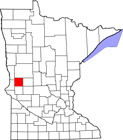
Barrett is a city in Grant County, Minnesota, United States. The population was 415 at the 2010 census. [5]
Barrett was platted in 1887. [6] The community was named for General Theodore H. Barrett. [7] A post office has been in operation at Barrett since 1887. [8] Barrett was incorporated as a city in 1889. [6]
According to the United States Census Bureau, the city has a total area of 2.11 square miles (5.46 km2), of which 2.09 square miles (5.41 km2) is land and 0.02 square miles (0.05 km2) is water. [9]
The town of Barrett wraps around the southwest side of Barrett Lake, which is formed by the Pomme de Terre River. [10]
Census | Pop. | Note | %± |
---|---|---|---|
1900 | 237 | — | |
1910 | 278 | 17.3% | |
1920 | 358 | 28.8% | |
1930 | 368 | 2.8% | |
1940 | 384 | 4.3% | |
1950 | 402 | 4.7% | |
1960 | 345 | −14.2% | |
1970 | 342 | −0.9% | |
1980 | 388 | 13.5% | |
1990 | 350 | −9.8% | |
2000 | 355 | 1.4% | |
2010 | 415 | 16.9% | |
2020 | 366 | −11.8% | |
U.S. Decennial Census [11] |
As of the census [12] of 2010, there were 415 people, 161 households, and 89 families residing in the city. The population density was 198.6 inhabitants per square mile (76.7/km2). There were 195 housing units at an average density of 93.3 per square mile (36.0/km2). The racial makeup of the city was 100.0% White. Hispanic or Latino of any race were 0.5% of the population.
There were 161 households, of which 29.8% had children under the age of 18 living with them, 40.4% were married couples living together, 8.1% had a female householder with no husband present, 6.8% had a male householder with no wife present, and 44.7% were non-families. 39.8% of all households were made up of individuals, and 23% had someone living alone who was 65 years of age or older. The average household size was 2.32 and the average family size was 3.01.
The median age in the city was 40.5 years. 24.3% of residents were under the age of 18; 6.1% were between the ages of 18 and 24; 21.9% were from 25 to 44; 18.6% were from 45 to 64; and 29.2% were 65 years of age or older. The gender makeup of the city was 49.6% male and 50.4% female.
As of the census [4] of 2000, there were 355 people, 142 households, and 81 families residing in the city. The population density was 172.2 inhabitants per square mile (66.5/km2). There were 163 housing units at an average density of 79.1 per square mile (30.5/km2). The racial makeup of the city was 98.87% White, 0.56% Native American, and 0.56% from two or more races.
There were 142 households, out of which 20.4% had children under the age of 18 living with them, 43.0% were married couples living together, 9.9% had a female householder with no husband present, and 42.3% were non-families. 38.0% of all households were made up of individuals, and 21.1% had someone living alone who was 65 years of age or older. The average household size was 2.05 and the average family size was 2.63.
In the city, the population was spread out, with 15.5% under the age of 18, 7.0% from 18 to 24, 19.4% from 25 to 44, 19.7% from 45 to 64, and 38.3% who were 65 years of age or older. The median age was 54 years. For every 100 females, there were 82.1 males. For every 100 females age 18 and over, there were 71.4 males.
The median income for a household in the city was $28,750, and the median income for a family was $37,813. Males had a median income of $27,500 versus $16,250 for females. The per capita income for the city was $13,954. About 6.8% of families and 8.8% of the population were below the poverty line, including 5.9% of those under age 18 and 12.9% of those age 65 or over.
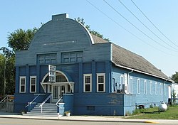
The “Annual Old Settlers Reunion” is held every year the weekend nearest to June 24. The event includes dinners, dances, parades, classic cars, ball games, and contests of all kinds, including a firefighters challenge. [1]
The Lakeside Pavilion is one of the few surviving lakeside facilities of its kind in Minnesota. The community of Barrett has worked to restore and renovate the Pavilion. It remains a popular place for dances and community events. The Pavilion available for rental May 1 through September 30.
The Barrett Lake Resort and Campground features a sandy beach and swimming area, game fishing, cabins and campsites and a general store. [13]
Michelle Jenson is the current mayor. [1]
Barrett is part of the West Central Area School District, which also includes the communities of Elbow Lake, Hoffman, Kensington, and Wendell. The West Central Area secondary school (grades 5-12) is located in Barrett, while elementary facilities are located in Elbow Lake and Kensington. Barrett was chosen as the location for the secondary facility as it is centrally located in the school district. The facility opened in the fall of 1995.
In August 1949, the nearest local newspaper to Barrett, the Elbow Lake Herald, reported that, five years earlier, farmer Victor Setterlund had found on his land, near Barrett Lake, a heart-shaped stone weighing about 75 pounds (34 kg), bearing a runic inscription. Translated, the runic message was "[Year ????]. Four maidens camped on this hill." Hjalmar Holand, principal promoter of the Kensington Runestone (not far to the south-east of Barrett in 1898) interpreted the year symbols as 1362, the same as the Kensington stone. Debunker Johan Holvik thought they should be read as 1776. The two experts agreed that the stone seemed to be a hoax. When Holvik revisited the area and asked Setterlund what the year symbols were meant to represent, the farmer confessed that he had carved the stone himself, using a list of runes in a textbook, and intended the date 1876, adding "It sure doesn't take much to put some people on if they want to believe you bad enough." [14]
Palisade is a city in Aitkin County, Minnesota, United States. The population was 167 at the 2010 census.
East Bethel is a city in Anoka County, Minnesota, United States. The population was 11,786 at the 2020 census.
Hackensack is a city in Cass County, Minnesota, United States. The population was 313 at the 2010 census. It is part of the Brainerd Micropolitan Statistical Area.
Lake Shore is a city in Cass County, Minnesota, United States. The population was 1,056 at the 2020 census. It is part of the Brainerd Micropolitan Statistical Area.
Chisago City is a city in Chisago County, Minnesota, United States, approximately 35 miles northeast of downtown Minneapolis–Saint Paul. The population was 4,967 at the 2010 census.
Kensington is a city in Douglas County, Minnesota, United States. The population was 266 at the 2020 census. The city is notable in Minnesota history for being the place where the Kensington Runestone was first displayed. It is now at a museum in nearby Alexandria, Minnesota.
Minnetrista is a city in Hennepin County, Minnesota, United States. Largely rural, Minnetrista has agricultural activity involving corn, soybeans, hay and horses. In addition to farmland and woods, the city is home to several lakes, including part of Lake Minnetonka, the state's ninth-biggest.
Clitherall is a city in Otter Tail County, Minnesota, United States. The population was 62 at the 2020 census.
Sturgeon Lake is a city in Pine County, Minnesota, United States. The population was 439 at the 2010 census.
Clear Lake is a city in Sherburne County, Minnesota, United States. The population was 641 at the 2020 census.
Balkan Township is a township in Saint Louis County, Minnesota, United States. The township was named after the Balkan Mountains. The population was 832 at the 2010 census.
Hoyt Lakes is a city in Saint Louis County, Minnesota. The population was 2,017 at the time of the 2010 census.
Lake Henry is a city in Stearns County, Minnesota, United States. The population was 103 at the 2010 census. It is part of the St. Cloud Metropolitan Statistical Area.
Maple Lake is a city in Wright County, Minnesota, United States. The population was 2,159 at the 2020 census. Minnesota State Highway 55 serves as a main route in the city.
Fifty Lakes is a city in Crow Wing County, Minnesota, United States. The population was 387 at the 2010 census. It is part of the Brainerd Micropolitan Statistical Area.
Lake Benton is a city in Lincoln County, Minnesota, United States. The population was 683 at the 2010 census.
Battle Lake is a city in Otter Tail County, Minnesota, United States. The population was 857 according to the 2020 census.
Elbow Lake is a city and county seat of Grant County, Minnesota, United States. The population was 1,276 at the 2020 census.
Minnesota Lake is a city in Blue Earth and Faribault counties in the State of Minnesota. The population was 661 at the 2020 census. The bulk of the city is in Faribault County; a small part extends into Blue Earth County.
Osakis is a city in Douglas and Todd counties in the U.S. state of Minnesota. The population was 1,771 at the 2020 census.