North Ottawa Township, Grant County, Minnesota

Last updated

North Ottawa Township
USA Minnesota location map.svg
Red pog.svg
North Ottawa Township
Location within the state of Minnesota
Usa edcp location map.svg
Red pog.svg
North Ottawa Township
North Ottawa Township (the United States)
Coordinates: 45°58′15″N96°12′42″W / 45.97083°N 96.21167°W / 45.97083; -96.21167
Country United States
State Minnesota
County Grant
Area
  Total35.8 sq mi (92.6 km2)
  Land35.8 sq mi (92.6 km2)
  Water0.0 sq mi (0.0 km2)
Elevation
1,027 ft (313 m)
Population
 (2000)
  Total69
  Density1.9/sq mi (0.7/km2)
Time zone UTC-6 (Central (CST))
  Summer (DST) UTC-5 (CDT)
FIPS code 27-47140 [1]
GNIS feature ID0665165 [2]

North Ottawa Township is a township in Grant County, Minnesota, United States. The population was 69 at the 2000 census.

Contents

History

North Ottawa Township was organized in 1882, and named after Ottawa, Illinois, the former home of an early settler. [3]

Geography

According to the United States Census Bureau, the township has a total area of 35.8 square miles (92.6 km2), all land.

Demographics

As of the census [1] of 2000, there were 69 people, 27 households, and 21 families residing in the township. The population density was 1.9 people per square mile (0.7/km2). There were 28 housing units at an average density of 0.8/sq mi (0.3/km2). The racial makeup of the township was 98.55% White, and 1.45% from two or more races.

There were 27 households, out of which 29.6% had children under the age of 18 living with them, 70.4% were married couples living together, 3.7% had a female householder with no husband present, and 22.2% were non-families. 14.8% of all households were made up of individuals, and 11.1% had someone living alone who was 65 years of age or older. The average household size was 2.56 and the average family size was 2.81.

In the township the population was spread out, with 26.1% under the age of 18, 10.1% from 18 to 24, 23.2% from 25 to 44, 24.6% from 45 to 64, and 15.9% who were 65 years of age or older. The median age was 42 years. For every 100 females, there were 91.7 males. For every 100 females age 18 and over, there were 96.2 males.

The median income for a household in the township was $36,875, and the median income for a family was $35,625. Males had a median income of $0 versus $41,250 for females. The per capita income for the township was $19,451. There were 21.7% of families and 18.9% of the population living below the poverty line, including 13.0% of under eighteens and none of those over 64.

Related Research Articles

Verona Township is a township in Faribault County, Minnesota, United States. The population was 391 at the 2000 census.

Jefferson Township is a township in Houston County, Minnesota, United States. The population was 129 at the 2000 census.

Bowstring Township is a township in Itasca County, Minnesota, United States. The population was 230 at the 2010 census.

Deer River Township is a township in Itasca County, Minnesota, United States. The population was 704 at the 2010 census.

Hamlin Township is a township in Lac qui Parle County, Minnesota, United States. The population was 185 at the 2000 census.

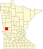
Ottawa Township is a township in Le Sueur County, Minnesota, United States. The population was 290 at the 2000 census. Ottawa Township was organized in 1858.

Whiteford Township is in Marshall County, Minnesota, United States. The population was 38 at the 2000 census.

Sundal Township is a township in Norman County, Minnesota, United States. The population was 145 at the 2000 census.

Hobart Township is a township in Otter Tail County, Minnesota, United States. The population was 733 at the 2000 census.

Homestead Township is a township in Otter Tail County, Minnesota, United States. The population was 371 at the 2000 census.

Otter Tail Township is a township in Otter Tail County, Minnesota, United States. The population was 556 at the 2000 census.

Fisher Township is a township in Polk County, Minnesota, United States. It is part of the Grand Forks-ND-MN Metropolitan Statistical Area. The population was 219 at the 2000 census.

Kertsonville Township is a township in Polk County, Minnesota, United States. It is part of the Grand Forks-ND-MN Metropolitan Statistical Area. The population was 105 at the 2000 census.

Lowell Township is a township in Polk County, Minnesota, United States. It is part of the Grand Forks-ND-MN Metropolitan Statistical Area. The population was 183 at the 2000 census.

<span class="mw-page-title-main">Roome Township, Polk County, Minnesota</span> Township in Minnesota, United States

Roome Township is a township in Polk County, Minnesota, United States. It is part of the Grand Forks-ND-MN Metropolitan Statistical Area. The population of the township was 185 at the 2000 census. The unincorporated community of Eldred is located within Roome Township.

Beaver Township is a township in Roseau County, Minnesota, United States. The population was 103 at the 2000 census.

Lake George Township is a township in Stearns County, Minnesota, United States. The population was 335 at the 2010 census.

St. Wendel Township is a township in Stearns County, Minnesota, United States. The population was 2,150 at the 2010 census.

Wilson Township is a township in Winona County, Minnesota, United States. The population was 1,177 at the 2010 census.

Maple Township is a township in Cass County, Minnesota, United States. The population was 291 as of the 2000 census. Maple Township was named from the groves of sugar maple trees within its borders.

References

  1. 1 2 "U.S. Census website". United States Census Bureau . Retrieved January 31, 2008.
  2. "US Board on Geographic Names". United States Geological Survey. October 25, 2007. Retrieved January 31, 2008.
  3. Upham, Warren (1920). Minnesota Geographic Names: Their Origin and Historic Significance. Minnesota Historical Society. p.  216.