Middlesex Fells Reservation, often referred to simply as the Fells, is a public recreation area covering more than 2,200 acres (890 ha) in Malden, Medford, Melrose, Stoneham, and Winchester, Massachusetts. The state park surrounds two inactive reservoirs, Spot Pond and the Fells Reservoir, and the three active reservoirs supplying the town of Winchester. Spot Pond and the Fells Reservoir are part of the Wachusett water system, one of six primary water systems that feed metropolitan Boston's waterworks. The park is managed by the Massachusetts Department of Conservation and Recreation and is part of the Metropolitan Park System of Greater Boston.

Temescal Regional Recreation Area (TRRA), formerly Lake Temescal Regional Park, is a regional park in the Berkeley Hills, in northeastern Oakland, California. The TRRA encompasses 48 acres (19 ha), abutting SR 24, SR13, and the interchange connecting the two highways, southwest of the Caldecott Tunnel.The park is part of the East Bay Regional Park District (EBRPD).
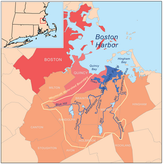
Blue Hills Reservation is a 6,000-acre (2,400 ha) state park in Norfolk County, Massachusetts. Managed by the Massachusetts Department of Conservation and Recreation, it covers parts of Milton, Quincy, Braintree, Canton, Randolph, and Dedham. Located approximately ten miles south of downtown Boston, the reservation is one of the largest parcels of undeveloped conservation land within the Greater Boston metropolitan area. The park's varied terrain and scenic views make it a popular destination for hikers from the Boston area.

Hunts Pond State Park is a former state park in Chenango County, New York, United States. The former park is located in the town of New Berlin, west of Route 8 and southwest of the village of New Berlin. It has been managed since 2011 as part of Hunts Pond State Forest.
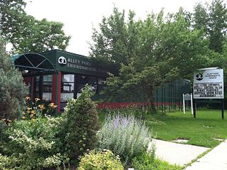
Alley Pond Park is the second-largest public park in Queens, New York City. It occupies 655.294 acres (265.188 ha), most of it acquired and cleared by the city in 1929, as authorized by a resolution of the New York City Board of Estimate in 1927. The park is bordered to the east by Douglaston, to the west by Bayside, to the north by Little Neck Bay, and to the south by Union Turnpike. It is run and operated by the New York City Department of Parks and Recreation.

Wells State Park is a public recreation area located off Route 49 in the town of Sturbridge, Massachusetts. The state park includes frontage on Walker Pond and the scenic metamorphic rock cliff face of Carpenter Rocks. Terrain is rugged with ledges interspersed between wetlands. Woodlands are of the oak-hickory forest and northern hardwood forest types with groves of eastern white pine. The park is managed by the Massachusetts Department of Conservation and Recreation.
Chicopee Memorial State Park is a public recreation area covering 562 acres (227 ha) in the Burnett Road neighborhood of the city of Chicopee, Massachusetts. The state park is located directly southeast of Westover Air Reserve Base, which is visible from some parts of the park. It is managed by the Department of Conservation and Recreation.
Beartown State Forest is a publicly owned forest with recreational features located in the towns of Great Barrington, Monterey, Lee, and Tyringham, Massachusetts. The state forest's more than 10,000 acres (4,000 ha) include 198 acres (80 ha) of recreational parkland. It is managed by the Massachusetts Department of Conservation and Recreation.

Dunn State Park is a public recreation area surrounding a 20-acre (8.1 ha) pond in Gardner, Massachusetts. The state park covers 132 acres (53 ha) and is managed by the Department of Conservation and Recreation.

Moore State Park is a 737-acre (298 ha) public recreation area located in the town of Paxton, Massachusetts, portions of which were listed on the National Register of Historic Places as the Moore State Park Historic District in 2004. Features of the state park include historical building foundations, a restored sawmill, Eames Pond, waterfalls and mill chutes as well as abundant azaleas, rhododendrons, and mountain laurel. The park is managed by the Massachusetts Department of Conservation and Recreation.

Leominster State Forest is a publicly owned forest with recreational features covering 4,246 acres (1,718 ha) in the Massachusetts towns of Leominster, Fitchburg, Princeton, Sterling, and Westminster. The state forest encompasses an extensive trail system, numerous small ponds, and the Crow Hills. Plants such as mountain laurel are common as is an abundance of wildlife. The forest is headquarters for Massachusetts Bureau of Forest Fire Control District 8 and is managed by the Department of Conservation and Recreation.

Sandy Island Beach State Park is a New York State park on the eastern shore of Lake Ontario. Its highlight is a 1,500-foot (460 m) natural sandy beach. The park is near the southern end of a notable 17-mile (27 km) length of sandy shoreline, coastal dunes, and wetlands ; a 1959 study noted that "The eastern end of Lake Ontario contains not only the finest beaches on the entire lake but also the finest wildlife habitat."
Weymouth Fore River is a small bay or estuary in eastern Massachusetts and is part of the Massachusetts Bay watershed.

Wendell State Forest is a Massachusetts state forest located in the town of Wendell. The 7,566-acre (3,062 ha) parcel occupies a forested and hilly upland plateau south of the Millers River and west of the Quabbin Reservoir. Park roads were developed by the Civilian Conservation Corps in the 1930s.

Houghton's Pond is a spring-fed kettle hole pond in Milton, Massachusetts, south of Boston. Like many ponds and lakes in the United States, it was formed by receding glaciers about 10,000 years ago. By the standard definition of lakes being bodies of water larger than 20 acres (8.1 ha), the 24-acre (9.7 ha) pond is technically a lake.

Waquoit Bay National Estuarine Research Reserve (WBNERR) encompasses open waters, barrier beaches, marshlands and uplands on the south shore of Cape Cod in the towns of Falmouth and Mashpee. The park is managed by the Department of Conservation and Recreation (DCR) and the National Oceanic and Atmospheric Administration.

Pearl Hill State Park is a 1,000-acre (400 ha) Massachusetts state park located in the town of Townsend about 50 miles (80 km) from Boston. The park lies adjacent to Willard Brook State Forest and is managed by the Department of Conservation and Recreation (DCR).
Blondin Park is an 8.5-hectare (21-acre) public park in Northfields in the London Borough of Ealing. It has allotments area and sports pitches. It is owned by Ealing Council and managed by the Council together with the Friends of Blondin Park. An area of 2.3 ha in the south-west corner is a Local Nature Reserve, and the nature area and allotments are a Site of Local Importance for Nature Conservation.
Dyken Pond is a 134-acre (54 ha) lake in the towns of Grafton and Berlin in Rensselaer County, New York. The pond gets water primarily from precipitation and outflows westward into the Poesten Kill, a tributary of the Hudson River. It is located in northwest Berlin, south of Grafton Lakes State Park.

The Doyle Community Park & Center, located in the city of Leominster, Massachusetts, is a 170-acre (69 ha) landscaped urban park and open space reservation managed by The Trustees of Reservations (TTOR), a non-profit conservation organization. It is also the location of TTOR's Doyle Center: a conservation education center, regional office, and green building initiative. The property consists of three main areas: Pierce Meadow, a landscaped urban park and former estate of Harry W. Pierce; the Doyle Center grounds, buildings, and adjoining woodlots; and a hay field and adjoining wetland.