
The European route E 22 is one of the longest European routes. It has a length of about 5,320 km (3,310 mi). Many of the E-roads have been extended into Asia since the year 2000; the E 22 was extended on 24 June 2002.

Eastern Beach is a suburb of Auckland, New Zealand. Located on the eastern city of the city centre, the suburb is in the Howick ward, one of the thirteen administrative divisions of Auckland City.

The Saxon Axis is a feature of the historical city centre of Warsaw. It is a line running from the Vistula through the Presidential Palace, the Krakowskie Przedmieście, Saxon Square, Saxon Palace, Saxon Garden, Lubomirski Palace to Plac Żelaznej Bramy.
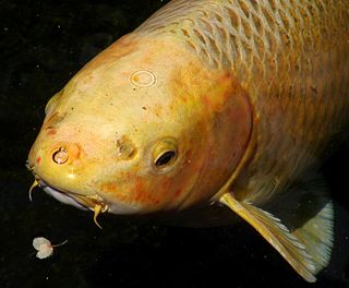
In fish anatomy and turtle anatomy, a barbel is a slender, whiskerlike sensory organ near the mouth. Fish that have barbels include the catfish, the carp, the goatfish, the hagfish, the sturgeon, the zebrafish, the black dragonfish and some species of shark such as the sawshark. Barbels house the taste buds of such fish and are used to search for food in murky water.

Kállósemjén is a village in Szabolcs-Szatmár-Bereg county, in the Northern Great Plain region of eastern Hungary.

Tsurumi-ryokuchi Station is a train station on the Osaka Metro Nagahori Tsurumi-ryokuchi Line in Tsurumi-ku, Osaka, Japan.

Ras-related protein Rap-2a is a protein that in humans is encoded by the RAP2A gene. RAP2A is a member of the Ras-related protein family.
Marysinek is a village in the administrative district of Gmina Strzegowo, within Mława County, Masovian Voivodeship, in east-central Poland.
Smętne is a village in the administrative district of Gmina Strzegowo, within Mława County, Masovian Voivodeship, in east-central Poland.
Szachowo is a village in the administrative district of Gmina Strzegowo, within Mława County, Masovian Voivodeship, in east-central Poland.
Wólka Brzezińska is a village in the administrative district of Gmina Goworowo, within Ostrołęka County, Masovian Voivodeship, in east-central Poland.

Janowice is a village in the administrative district of Gmina Wierzbinek, within Konin County, Greater Poland Voivodeship, in west-central Poland. It lies approximately 5 kilometres (3 mi) north of Wierzbinek, 34 km (21 mi) north-east of Konin, and 109 km (68 mi) east of the regional capital Poznań.
Suskowo is a village in the administrative district of Gmina Wierzbinek, within Konin County, Greater Poland Voivodeship, in west-central Poland.
Greek National Road 50 is a national highway on the island of Cephalonia, Greece. It connects Argostoli with Sami.
The Royal Corps of Colonial Troops was a corps of the Italian armed forces, in which all the Italian colonial troops were grouped until the end of World War II in Africa.

Ploug House is a listed Neoclassical property on the corner of Højbro Plads and Ved Stranden in central Copenhagen, Denmark. It dates from the building boom which followed after the Copenhagen Fire of 1795 but takes its name after the poet, publisher and politician Carl Ploug who lived there in the 1860s and 1870s and also published the newspaper ''Fædrelandet from the premises.
Elvanlar is a village in the District of Kurucaşile, Bartın Province, Turkey. As of 2010 it had a population of 244 people.
Dang‘ara District is a tuman (district) of Fergana Region in Uzbekistan. The capital lies at Dang‘ara.

Museo capitolare di Atri is a museum of religious art in Atri, Province of Teramo (Abruzzo).
Lacul Negru is a natural salt lake in the town of Ocna Sibiului, Sibiu County, Transylvania, Romania. It is one of the many lakes of the Ocna Sibiului mine, a large salt mine which has gotten one of the largest salt reserves in Romania. It has one of the smallest depths of all the lakes, with its maximum depth only reaching about 1m.


