
Siyəzən is a city and municipality in, and the capital of, the Siazan Rayon of Azerbaijan. It has a population of 24,900.
Ulaankhus is a sum (district) of Bayan-Ölgii Province in western Mongolia. It is primarily inhabited by ethnic Kazakhs.

Karl-Marx-Straße is a Berlin U-Bahn station located on the U 7. The station was opened in 1926 as "Bergstrasse" and renamed in 1946, and although Karl Marx was a hero of the socialist republic of East Germany the station is in former West Berlin. 1968 the station was elongated to 105m, due to this a lot of the original appearance was lost. 1993 parts of the platform fell into the rail track so that the station had to be closed for a few days. The station is one stop away from Neukölln station, where passengers can change to S-Bahn lines.
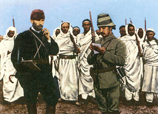
Battle of Tobruk (1911) or Nadura Hill Battle was a small engagement in the Italo-Turkish War. It is mostly known for the involvement and leadership of future Turkish president Mustafa Kemal.

Silikyan, formerly Spandaryan, is a neighbourhood of the Ajapnyak District of the Armenian capital Yerevan
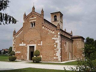
Santa Maria Maggiore is a church in Gazzo Veronese, a village near Verona, region of Veneto, in northern Italy.
Choibalsan District is a sum (district) of Dornod Province in eastern Mongolia. Sum center is 55 km North from the Dornod aimag capital Choibalsan city. Sum center has railway station Kherlengol on the Borzya (Russia) - Choibalsan city line.

Swan Island is a small, privately owned island in the River Thames at Twickenham, in the London Borough of Richmond upon Thames, London, England. It is situated on the Tideway about 3⁄4 mile (1.2 km) downstream of Teddington Lock.

Dian is a town in the Aragatsotn Province of Armenia.
Berżniki-Folwark is a village in the administrative district of Gmina Sejny, within Sejny County, Podlaskie Voivodeship, in north-eastern Poland, close to the border with Lithuania.

Klimówka is a village in the administrative district of Gmina Kuźnica, within Sokółka County, Podlaskie Voivodeship, in north-eastern Poland, close to the border with Belarus. It lies approximately 9 kilometres (6 mi) south of Kuźnica, 13 km (8 mi) east of Sokółka, and 50 km (31 mi) north-east of the regional capital Białystok.
Stary Folwark is a village in the administrative district of Gmina Suwałki, within Suwałki County, Podlaskie Voivodeship, in north-eastern Poland. It lies approximately 10 kilometres (6 mi) east of Suwałki and 107 km (66 mi) north of the regional capital Białystok.
Katarzynka is a village in the administrative district of Gmina Drużbice, within Bełchatów County, Łódź Voivodeship, in central Poland. It lies approximately 4 kilometres (2 mi) south of Drużbice, 9 km (6 mi) north of Bełchatów, and 39 km (24 mi) south of the regional capital Łódź.
Konary is a village in the administrative district of Gmina Krzyżanów, within Kutno County, Łódź Voivodeship, in central Poland.
Solec is a village in the administrative district of Gmina Gostynin, within Gostynin County, Masovian Voivodeship, in east-central Poland.
Mežotne parish is an administrative unit of the Bauska Municipality, Latvia.

Hawk Ravine is a former settlement in Butte County, California. It lay at an elevation of 1266 feet. It still appeared on maps as of 1897.
Silla is a village in Lääne-Nigula Parish, Lääne County, in western Estonia.
Käru is a village in Väike-Maarja Parish, Lääne-Viru County, in northeastern Estonia.

Őrhalom is a village in Nógrád County, Hungary with 967 inhabitants (2014).


