Gmina Kamionka Wielka is a rural gmina in Nowy Sącz County, Lesser Poland Voivodeship, in southern Poland. Its seat is the village of Kamionka Wielka, which lies approximately 9 kilometres (6 mi) south-east of Nowy Sącz and 82 km (51 mi) south-east of the regional capital Kraków.
Gmina Łabowa is a rural gmina in Nowy Sącz County, Lesser Poland Voivodeship, in southern Poland. Its seat is the village of Łabowa, which lies approximately 16 kilometres (10 mi) south-east of Nowy Sącz and 89 km (55 mi) south-east of the regional capital Kraków.
Gmina Piwniczna-Zdrój is an urban-rural gmina in Nowy Sącz County, Lesser Poland Voivodeship, in southern Poland, on the Slovak border. Its seat is the town of Piwniczna-Zdrój, which lies approximately 21 kilometres (13 mi) south of Nowy Sącz and 89 km (55 mi) south-east of the regional capital Kraków.
Gmina Rytro is a rural gmina in Nowy Sącz County, Lesser Poland Voivodeship, in southern Poland. Its seat is the village of Rytro, which lies approximately 16 kilometres (10 mi) south of Nowy Sącz and 83 km (52 mi) south-east of the regional capital Kraków.
Gmina Stary Sącz is an urban-rural gmina in Nowy Sącz County, Lesser Poland Voivodeship, in southern Poland. Its seat is the town of Stary Sącz, which lies approximately 9 kilometres (6 mi) south-west of Nowy Sącz and 75 km (47 mi) south-east of the regional capital Kraków.

Kunów is a village in the administrative district of Gmina Chełmiec, within Nowy Sącz County, Lesser Poland Voivodeship, in southern Poland. It lies approximately 8 kilometres (5 mi) south-east of Chełmiec, 6 km (4 mi) south-east of Nowy Sącz, and 79 km (49 mi) south-east of the regional capital Kraków.
Bartkowa is a village in the administrative district of Gmina Gródek nad Dunajcem, within Nowy Sącz County, Lesser Poland Voivodeship, in southern Poland. It lies approximately 17 kilometres (11 mi) north of Nowy Sącz and 67 km (42 mi) south-east of the regional capital Kraków.
Łęki is a village in the administrative district of Gmina Łososina Dolna, within Nowy Sącz County, Lesser Poland Voivodeship, in southern Poland. It lies approximately 3 kilometres (2 mi) north-west of Łososina Dolna, 17 km (11 mi) north of Nowy Sącz, and 59 km (37 mi) south-east of the regional capital Kraków.
Stańkowa is a village in the administrative district of Gmina Łososina Dolna, within Nowy Sącz County, Lesser Poland Voivodeship, in southern Poland. It lies approximately 7 kilometres (4 mi) south-west of Łososina Dolna, 15 km (9 mi) north-west of Nowy Sącz, and 59 km (37 mi) south-east of the regional capital Kraków.
Bącza Kunina is a village in the administrative district of Gmina Nawojowa, within Nowy Sącz County, Lesser Poland Voivodeship, in southern Poland. It lies approximately 2 kilometres (1 mi) south-east of Nawojowa, 10 km (6 mi) south-east of Nowy Sącz, and 82 km (51 mi) south-east of the regional capital Kraków.
Frycowa is a village in the administrative district of Gmina Nawojowa, within Nowy Sącz County, Lesser Poland Voivodeship, in southern Poland. It lies approximately 4 kilometres (2 mi) east of Nawojowa, 11 km (7 mi) south-east of Nowy Sącz, and 84 km (52 mi) south-east of the regional capital Kraków.
Homrzyska is a village in the administrative district of Gmina Nawojowa, within Nowy Sącz County, Lesser Poland Voivodeship, in southern Poland. It lies approximately 6 kilometres (4 mi) south-east of Nawojowa, 13 km (8 mi) south-east of Nowy Sącz, and 86 km (53 mi) south-east of the regional capital Kraków.
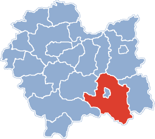
Nawojowa is a village in Nowy Sącz County, Lesser Poland Voivodeship, in southern Poland. It is the seat of the gmina called Gmina Nawojowa. It lies approximately 8 kilometres (5 mi) south-east of Nowy Sącz and 81 km (50 mi) south-east of the regional capital Kraków.
Żeleźnikowa Mała is a village in the administrative district of Gmina Nawojowa, within Nowy Sącz County, Lesser Poland Voivodeship, in southern Poland. It lies approximately 4 kilometres (2 mi) west of Nawojowa, 9 km (6 mi) south of Nowy Sącz, and 79 km (49 mi) south-east of the regional capital Kraków.
Zubrzyk is a village in the administrative district of Gmina Piwniczna-Zdrój, within Nowy Sącz County, Lesser Poland Voivodeship, in southern Poland, close to the border with Slovakia. It lies approximately 6 kilometres (4 mi) south-east of Piwniczna-Zdrój, 26 km (16 mi) south of Nowy Sącz, and 95 km (59 mi) south-east of the regional capital Kraków.
Gaboń-Praczka is a village in the administrative district of Gmina Stary Sącz, within Nowy Sącz County, Lesser Poland Voivodeship, in southern Poland. It lies approximately 8 kilometres (5 mi) south-west of Stary Sącz, 16 km (10 mi) south-west of Nowy Sącz, and 76 km (47 mi) south-east of the regional capital Kraków.
Mostki is a village in the administrative district of Gmina Stary Sącz, within Nowy Sącz County, Lesser Poland Voivodeship, in southern Poland. It lies approximately 4 kilometres (2 mi) west of Stary Sącz, 11 km (7 mi) south-west of Nowy Sącz, and 74 km (46 mi) south-east of the regional capital Kraków.
Myślec is a village in the administrative district of Gmina Stary Sącz, within Nowy Sącz County, Lesser Poland Voivodeship, in southern Poland. It lies approximately 3 kilometres (2 mi) south-east of Stary Sącz, 9 km (6 mi) south of Nowy Sącz, and 78 km (48 mi) south-east of the regional capital Kraków.
Popowice is a village in the administrative district of Gmina Stary Sącz, within Nowy Sącz County, Lesser Poland Voivodeship, in southern Poland. It lies approximately 4 kilometres (2 mi) south-east of Stary Sącz, 10 km (6 mi) south of Nowy Sącz, and 78 km (48 mi) south-east of the regional capital Kraków.