Marsh Lock is a lock and weir situated on the River Thames in England near Henley-on-Thames, Oxfordshire. The lock is close to the Berkshire bank, but accessed from the Oxfordshire side via two long walkways, the downstream one being near Mill Meadows. The first pound lock was built by the Thames Navigation Commission in 1773.

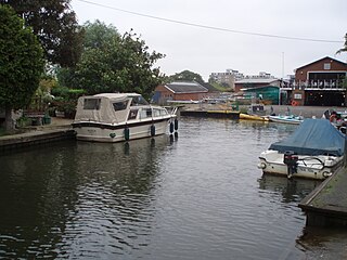
Shiplake Lock is a lock and weir situated on the River Thames in England near the village of Shiplake, Oxfordshire. It is just above the points where the River Loddon joins the Thames and Shiplake Railway Bridge crosses the river. The first pound lock was built by the Thames Navigation Commission in 1773.
Trowlock Island is a residential island in the River Thames 450 metres (490 yd) upstream of Teddington Lock on the non-tidal Kingston reach less than 10 metres from the northern bank, in the London Borough of Richmond upon Thames, England.

Wargrave is a large, historic village and civil parish in Berkshire, England. The village is primarily on the River Thames but also along the confluence of the River Loddon. Wargrave is situated in the A321 road 7 miles (11 km) from both Maidenhead and Reading and 3 miles (4.8 km) from Henley-on-Thames. The village is larger than the county average, having a railway station on the Henley Branch Line, off the Great Western main line from London Paddington; the village is quickly accessible to nearby parts of the M4 corridor, particularly Berkshire and Heathrow Airport and local major centres of employment include Reading and Maidenhead, with smaller businesses and additional commercial facilities in nearby Henley-on-Thames and Wokingham. The village has many old listed buildings, two marinas with chandlery services for boats, a rowing club and rises steeply to the northwest in the direction of Bowsey Hill, with higher parts of the village generally known as Upper Wargrave. In Upper Wargrave is a Recreation Ground with a cricket club, bowls club, football pitch and tennis club.

Shiplake College is an independent boarding and day school in Shiplake, by the River Thames just outside Henley-on-Thames, England. The school, with 480 pupils, takes boys from 11–18 and girls from 16–18.

Phillimore Island is an elongated island in the River Thames in the county of Berkshire, England, near the villages of Shiplake, Oxfordshire and Wargrave, Berkshire. It is on the reach above Shiplake Lock.
Sonning Regatta is the regatta of the village of Sonning in Berkshire and the hamlet of Sonning Eye in Oxfordshire, England, on the north and south banks of the River Thames.

The Wargrave & Shiplake Regatta is a regatta on the River Thames in England. It is the local regatta of the villages of Wargrave in Berkshire and Shiplake in Oxfordshire. Some of the boats used are of a traditional clinker-built style, others are fibre-glass.

Eye and Dunsden is a largely rural civil parish in the most southern part of English county of Oxfordshire.

Shiplake Railway Bridge carries the Henley Branch Line to Henley-on-Thames, England across the River Thames, connecting Shiplake in Oxfordshire with Wargrave in Berkshire. It crosses the river just downstream of Shiplake Lock on the reach above Marsh Lock.

Corporation Island is an island in the River Thames in England. It is on the Tideway near Twickenham between Richmond Bridge and Richmond Railway Bridge and is opposite the river frontage at Richmond, London, England.

Buck Ait is an island in the River Thames in Oxfordshire, England. It is on the reach above Shiplake Lock near Sonning.

The Lynch is an island in the River Thames in Berkshire, England. It is on the reach above Shiplake Lock near Lower Shiplake.
Hallsmead Ait is an island in the River Thames in Berkshire, England. It is on the reach above Shiplake Lock near Lower Shiplake.

Handbuck Eyot or Handbuck Ait is a thin, wooded island in the River Thames in England towards the eastern edge of the villages of Shiplake, Oxfordshire. It is on the reach above Marsh Lock.

Ferry Eyot or Ferry Ait is an island in the River Thames in England near the villages of Shiplake, Oxfordshire and Wargrave, Berkshire. It is on the reach above Marsh Lock.

St Patrick's Stream or Patrick Stream is a backwater of the River Thames in England, which flows into the River Loddon near Wargrave, Berkshire. It leaves the Thames on the reach above Shiplake Lock near Buck Ait, downstream of Sonning.
The Unnamed Eyot is an island in the River Thames in Berkshire, England, north of the village of Wargrave, Berkshire, its parish in civil terms and ecclesiastical parish in the Church of England. It is on the reach above Marsh Lock.
Hennerton Backwater is a narrow backwater of the River Thames on the reach above Marsh Lock near the villages of Shiplake, Oxfordshire and Wargrave, Berkshire.