Marsh Lock

Last updated

Marsh Lock
MarshLock01.JPG
Marsh Lock from the upstream walkway with the weir on the left
Waterway River Thames
County Berkshire
Maintained by Environment Agency
OperationHydraulic
First built1773
Latest built1914
Length41.19 m (135 ft 2 in) [1]
Width6.42 m (21 ft 1 in) [1]
Fall1.33 m (4 ft 4 in) [1]
Above sea level105'
Distance to
Teddington Lock
46 miles
Marsh Lock
BSicon uSTR.svg
River Thames
BSicon uexSTR+l.svg
BSicon ueABZgr.svg
BSicon uxWEIRg.svg
BSicon ueABZgl.svg
BSicon uexSTR+r.svg
BSicon uSTR.svg
BSicon uFGATEu.svg
BSicon ueMILL.svg
Shiplake Lock
BSicon uSTR.svg
BSicon ueABZg+l.svg
BSicon uexSTRr.svg
Site of mill
BSicon uSTRl.svg
BSicon uABZg+r.svg
BSicon uexSTRq.svg
BSicon ueABZg+r.svg
River Loddon
BSicon uexSTR+l.svg
BSicon ueABZgr.svg
BSicon uxmKRZu.svg
BSicon umKRZu.svg
Shiplake Railway Bridge
BSicon uddSTRl.svg
BSicon uSTR.svg
BSicon uSTRl.svg
BSicon uFABZgr+r.svg
BSicon uSTR+l.svg
BSicon uFABZgr+r.svg
BSicon uddSTRl.svg
BSicon uSTR.svg
moorings
BSicon uFABZgl+l.svg
BSicon uFABZgr+r.svg
BSicon uddSTRl.svg
BSicon uSTR.svg
moorings
BSicon uexSTR.svg
BSicon ueISLAND.svg
island
BSicon uexSTR.svg
BSicon uISLAND.svg
Poplar Eyot
BSicon uexSTR.svg
BSicon ueISLAND.svg
island
BSicon uexSTRl.svg
BSicon ueABZg+r.svg
Hennerton Backwater
BSicon uSTR.svg
BSicon uSTR+l.svg
BSicon uABZgr.svg
BSicon uexSTRl.svg
BSicon uexABZq+r.svg
BSicon uexSTR+r.svg
BSicon uSTR.svg
BSicon uFGATEu.svg
BSicon uxWEIRg.svg
BSicon uexSTR.svg
Marsh Lock and weir
BSicon uSTR.svg
BSicon ueABZg+l.svg
BSicon uexSTRr.svg
BSicon uxWEIRg.svg
BSicon ueMILL.svg
BSicon ueABZg+l.svg
BSicon uexSTRq.svg
BSicon uexSTRr.svg
Site of mill
BSicon uSTRl.svg
BSicon uABZg+r.svg
BSicon uSTR.svg
River Thames
Marsh Lock filled by a large riverboat MarshLock03.JPG
Marsh Lock filled by a large riverboat
Marsh Lock empty from the tail gates 2008-05 Marsh Lock.JPG
Marsh Lock empty from the tail gates

Marsh Lock is a lock and weir situated on the River Thames in England, about 1 mile upstream of Henley Bridge in Henley-on-Thames, Oxfordshire. The lock is close to the Berkshire bank, but accessed from the Oxfordshire side via two long walkways, the downstream one being near Mill Meadows. The first pound lock was built by the Thames Navigation Commission in 1773.

Contents

The weir consists of a series of iron watergates running from the lock to the Oxfordshire bank near the mills. It is situated between the two walkways.

History

The earliest record of a flash lock is in 1580, but the lock and weir existed for some time before that. The pound lock was the third downstream of the eight locks built after the navigation act of 1770, and was completed in fir wood in 1773. Humphrey Gainsborough, a non-conformist minister at Henley Congregational Church was concerned in the building of the lock. He was an inventor and the brother of the artist Thomas Gainsborough. By 1780 the lock was reported as decaying fast, and in 1787 it was rebuilt of oak. The first lock-house was built in 1813. Positioned as it was on the opposite side of the tow path, the lock was considered "Extremely inconvenient and dangerous for barges" in 1814 and there are some indications that the flash lock was still in use.

Lower walkway from Mill Meadows MarshLock02.JPG
Lower walkway from Mill Meadows

In 1843 the lock was in poor condition and plans were drawn up to rebuild it on the opposite side of the river. However these came to nothing and the lower walkway was built about this time. The weir was rebuilt after 1879 but with some complaints about its unattractiveness. There were again proposals to move the lock across the river but it was rebuilt of more solid timber and reopened in 1886. [2] The lock was rebuilt again in 1914. The weir was reconstructed in 2004 by Mowlem PLC to a design by Halcrow Group.

Access to the lock

Because the lock is unusually situated on the opposite side of the river to the towpath, a long wooden bridge was built from the Oxfordshire bank to carry the path out to the lock island below the weir, and then back again to the riverbank above the weir. This feature is unique on the River Thames.

Reach above the lock

View upstream from the upstream walkway MarshLock04.JPG
View upstream from the upstream walkway
View of Wargrave across the river from Shiplake WargraveRiver01.JPG
View of Wargrave across the river from Shiplake

At the lock and beyond it on the Berkshire bank there are steep hills, which give way to Wargrave Marsh, an expanse of water meadows, after the entrance to the Hennerton Backwater. At this point, Bolney Ferry used to operate across the river. The island here is called Ferry Eyot and it is followed by Poplar Eyot and Handbuck Eyot. This chain of islands lies off a range of large houses at Shiplake.

The river then rejoins Hennerton Backwater and passes Wargrave on the Berkshire bank while there is then open farmland on the Shiplake bank. The River Loddon flows in on the Berkshire side and the river is crossed by Shiplake Railway Bridge just below Shiplake Lock. The Wargrave & Shiplake Regatta takes place on the reach downstream of the railway bridge in August.

Thames Path

The Thames Path follows the river on the western bank and then takes a diversion through Shiplake, rejoining the river at Shiplake Lock. This diversion arises because: firstly, the towpath used to cross the river at Bolney Ferry and return at Lashbrook Ferry a short way upstream; secondly there is no easy access to rejoin the path for the section between Lashbrook Ferry and Shiplake Lock.

See also

Next lock upstream River Thames Next lock downstream
Shiplake Lock
4.80 km (2.98 mi) [3]
Marsh Lock
Grid reference: SU773816
Hambleden Lock
4.59 km (2.85 mi) [3]

Coordinates: 51°31′41″N0°53′14″W / 51.52803°N 0.88710°W / 51.52803; -0.88710

Related Research Articles

Caversham Lock Lock and weir on the River Thames in Berkshire, England

Caversham Lock is a lock and main weir on the River Thames in England at Reading, Berkshire. Both the lock and main weir are connected to De Bohun Island. The Thames Navigation Commissioners built the original lock in 1778. Additional sluices north of View Island and Heron Island form the whole weir complex. A footbridge passes over all three islands to connect Lower Caversham to Reading via a route other than George Street and Reading Bridge.

Bray Lock Lock and weir on the River Thames in Buckinghamshire, England

Bray Lock is a lock and weir on the River Thames in England near Bray and Dorney Reach, and is just above the M4 Bridge across the Thames. The lock is on the Buckinghamshire side of the river on the opposite bank from Bray itself and Maidenhead which are in Berkshire. Here, the county line stands roughly halfway between the lock and the opposite bank, following the course of the Thames itself. The pound lock was built by the Thames Navigation Commission relatively late, in 1845. The lock keeper's cottage is on an island between the lock and the weir.

Shiplake Lock Lock on the River Thames in Oxfordshire, England

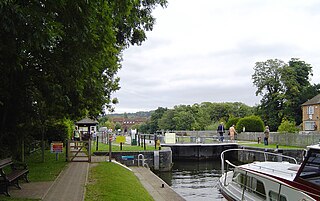
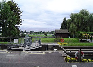
Shiplake Lock is a lock and weir situated on the River Thames in England between the villages of Shiplake and Lower Shiplake, Oxfordshire. It is just above the points where the River Loddon joins the Thames and Shiplake Railway Bridge crosses the river. The first pound lock was built by the Thames Navigation Commission in 1773.

Sonning Bridge

Sonning Bridge is a road bridge across the River Thames at Sonning, Berkshire. It links Sonning with Sonning Eye (Oxfordshire) and crosses the Thames on the reach above Shiplake Lock, just short of Sonning Lock. It is a brick arch bridge completed in 1775, to replace an earlier wooden bridge. The bridge has been the subject of many paintings and prints by artists and is a Grade II listed building.

Cookham Lock Lock and weirs on the River Thames in Berkshire, England

Cookham Lock is a lock with weirs situated on the River Thames near Cookham, Berkshire, about a half-mile downstream of Cookham Bridge. The lock is set in a lock cut which is one of four streams here and it is surrounded by woods. On one side is Sashes Island and on the other is Mill Island connected to Formosa Island, the largest on the non-tidal Thames.

Thames Path National Trail following the River Thames in England

The Thames Path is a National Trail following the River Thames from its source near Kemble in Gloucestershire to the Thames Barrier at Charlton, south east London. It is about 184 miles (296 km) long. A path was first proposed in 1948 but it only opened in 1996.

Hambleden Lock Lock on the River Thames in Berkshire, England

Hambleden Lock is a lock with a long weir situated on the River Thames in England, about 2 miles downstream of Henley Bridge. The lock is on the Berkshire bank between Aston and Remenham. Built by the Thames Navigation Commission in 1773, the lock is named after the village of Hambleden, a mile (1.5 km) to the north.

Phillimore Island

Phillimore Island is an elongated island in the River Thames in the county of Berkshire, England, near the villages of Shiplake, Oxfordshire and Wargrave, Berkshire. It is on the reach above Shiplake Lock.

Wargrave & Shiplake Regatta Regatta on the River Thames in England

The Wargrave & Shiplake Regatta is a regatta on the River Thames in England. It is the local regatta of the villages of Wargrave in Berkshire and Shiplake in Oxfordshire. Some of the boats used are of a traditional clinker-built style, others are fibre-glass.

Molesey Lock Lock on the River Thames in Surrey, England

Molesey Lock is a lock on the River Thames in England at East Molesey, Surrey on the right bank.

Temple Lock Lock and weir on the River Thames in Buckinghamshire, England

Temple Lock is a lock and weir situated on the Buckinghamshire bank of the River Thames near Temple Mill Island opposite Temple Meadows and not far from Hurley, Berkshire. It was first built by the Thames Navigation Commissioners in 1773.

Sunbury Lock Lock on the River Thames in Surrey, England

Sunbury Lock is a lock complex of the River Thames in England near Walton-on-Thames in north-west Surrey, the third lowest of forty four on the non-tidal reaches. The complex adjoins the right, southern bank about 12 mile (0.80 km) downstream of the Weir Hotel.

Old Windsor Lock Lock on the River Thames in Berkshire, England

Old Windsor Lock is a lock on the River Thames in England on the right bank beside Old Windsor, Berkshire. The lock marks the downstream end of the New Cut, a meander cutoff built in 1822 by the Thames Navigation Commissioners which created Ham Island. The lock and a wider footbridge give access to the island. Two weirs are associated; the smaller adjoins and the larger is upstream. The lock is the ninth lowest of the forty-five on the river.

Boveney Lock Lock on the River Thames in Buckinghamshire, England

Boveney Lock is a lock on the River Thames situated on the Buckinghamshire bank opposite the Windsor Racecourse and close to Eton Wick. Boveney is a village a little way upstream on the same side. The lock was first built in 1838 by the Thames Navigation Commission. The lock was rebuilt in 1898 closer to the Buckinghamshire bank, and a set of boat rollers were installed on the old site.

Shifford Lock Lock on the River Thames, England

Shifford Lock is a lock on the River Thames in England. It is in the centre of a triangle formed by the small villages of Shifford, Duxford and Chimney in Oxfordshire. It is at the start of a navigation cut built with the lock by the Thames Conservancy in 1898. This was the only new lock built on the non-tidal Thames in the era of falling revenue after the Thames Conservancy took over responsibilities of the Thames Navigation Commission. It replaced a flash lock in a weir about 34 mile (1.2 km) downstream.

Radcot Lock

Radcot Lock is a lock on the River Thames in England just downstream of Radcot, Oxfordshire, on the southern bank.

Ferry Eyot

Ferry Eyot or Ferry Ait is an island in the River Thames in England near the villages of Shiplake, Oxfordshire and Wargrave, Berkshire. It is on the reach above Marsh Lock.

St Patricks Stream

St Patrick's Stream or Patrick Stream is a backwater of the River Thames in England, which flows into the River Loddon near Wargrave, Berkshire. It leaves the Thames on the reach above Shiplake Lock near Buck Ait, downstream of Sonning.

Poplar Eyot or Poplar Ait is an island in the River Thames in England near the villages of Shiplake, Oxfordshire and Wargrave, Berkshire. It is on the reach above Marsh Lock.

Hennerton Backwater is a narrow backwater of the River Thames on the reach above Marsh Lock near the villages of Shiplake, Oxfordshire and Wargrave, Berkshire.

References

  1. 1 2 3 "A User's Guide to the River Thames" (PDF). PDF file. Environmental Agency. 2009. pp. 29–30. Archived from the original (PDF) on 28 December 2013. Retrieved 12 November 2012. Dimensions given in metres.
  2. Fred. S. Thacker The Thames Highway: Volume II Locks and Weirs 1920 - republished 1968 David & Charles
  3. 1 2 "Environment Agency Distances between locks on the River Thames". web page. Environmental Agency. 19 November 2012. Retrieved 21 November 2012. Distances given in km