
Marsh Lock is a lock and weir situated on the River Thames in England, about 1 mile upstream of Henley Bridge in Henley-on-Thames, Oxfordshire. The lock is close to the Berkshire bank, but accessed from the Oxfordshire side via two long walkways, the downstream one being near Mill Meadows. The first pound lock was built by the Thames Navigation Commission in 1773.

Shiplake Lock is a lock and weir situated on the River Thames in England between the villages of Shiplake and Lower Shiplake, Oxfordshire. It is just above the points where the River Loddon joins the Thames and Shiplake Railway Bridge crosses the river. The first pound lock was built by the Thames Navigation Commission in 1773.

Sonning Bridge is a road bridge across the River Thames at Sonning, Berkshire. It links Sonning with Sonning Eye (Oxfordshire) and crosses the Thames on the reach above Shiplake Lock, just short of Sonning Lock. It is a brick arch bridge completed in 1775, to replace an earlier wooden bridge. The bridge has been the subject of many paintings and prints by artists and is a Grade II listed building.

Shiplake consists of three settlements: Shiplake, Shiplake Cross and Lower Shiplake. Together these villages form a civil parish situated beside the River Thames 2 miles (3 km) south of Henley-on-Thames, Oxfordshire, England. The river forms the parish boundary to the east and south, and also the county boundary between Oxfordshire and Berkshire. The villages have two discrete centres separated by agricultural land. The 2011 Census records the parish population as 1,954 and containing 679 homes. The A4155 main road linking Henley with Reading, Berkshire passes through the parish.

Wargrave is a historic village and civil parish in Berkshire, England. The village is primarily on the River Thames but also along the confluence of the River Loddon and lies on the border with southern Oxfordshire. The village has many old listed buildings, two marinas with chandlery services for boats, a boating club and rises steeply to the northeast in the direction of Bowsey Hill, with higher parts of the village generally known as Upper Wargrave. In Upper Wargrave is a Recreation Ground with a cricket club, bowls club, football pitches and tennis club.
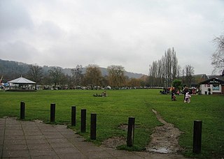
Mill Meadows is part of the flood plain of the River Thames at Henley-on-Thames, Oxfordshire, England. It is an area of natural beauty close to the town centre of Henley. Marsh Lock.
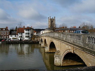
Henley Bridge is a road bridge built in 1786 at Henley-on-Thames over the River Thames, between Oxfordshire and Berkshire. The bridge has five elliptical stone arches, and links Hart Street in Henley with White Hill leading up a steep hill to Remenham Hill. It crosses the Thames on the reach between Hambleden Lock and Marsh Lock, carrying the Thames Path across the river. It is a Grade I listed building.

Shiplake railway station is in the village of Lower Shiplake in Oxfordshire, England. The station is on the Henley-on-Thames branch line that links the towns of Henley-on-Thames and Twyford. It is 2 miles 60 chains (4.4 km) down the line from Twyford and 33 miles 61 chains (54.3 km) from London Paddington.

Henley-on-Thames is a terminal railway station in the town of Henley-on-Thames in Oxfordshire, England. The station is on the Henley Branch Line that links the towns of Henley and Twyford. It is 4 miles 47 chains (7.4 km) down the line from Twyford and 35 miles 48 chains (57.3 km) from London Paddington.

The Henley branch line is a branch railway line between Twyford in Berkshire and Henley-on-Thames in Oxfordshire. It was built by the Great Western Railway in 1857. Train services are provided by the present day Great Western Railway train operating company.

Phillimore Island is an elongated island in the River Thames in the county of Berkshire, England, near the villages of Shiplake, Oxfordshire and Wargrave, Berkshire. It is on the reach above Shiplake Lock.

Sonning Regatta is the regatta of the village of Sonning in Berkshire and the hamlet of Sonning Eye in Oxfordshire, England, on the north and south banks of the River Thames. It is a part of the Sonning Festival.

The Wargrave & Shiplake Regatta is a regatta on the River Thames in England. It is the local regatta of the villages of Wargrave in Berkshire and Shiplake in Oxfordshire. Some of the boats used are of a traditional clinker-built style, others are fibre-glass.

Culham Lock is a lock on the River Thames in England close to Culham, Oxfordshire. It is on a lock cut to the north of the main stream, which approaches the large village of Sutton Courtenay. The lock was built of stone by the Thames Navigation Commission in 1809.

Buck Ait is an island in the River Thames in Oxfordshire, England. It is on the reach above Shiplake Lock near Sonning.
The Lynch is an island in the River Thames in Berkshire, England. It is on the reach above Shiplake Lock near Lower Shiplake.

Ferry Eyot or Ferry Ait is an island in the River Thames in England near the villages of Shiplake, Oxfordshire and Wargrave, Berkshire. It is on the reach above Marsh Lock.

St Patrick's Stream or Patrick Stream is a backwater of the River Thames in England, which flows into the River Loddon near Wargrave, Berkshire. It leaves the Thames on the reach above Shiplake Lock near Buck Ait, downstream of Sonning.
Poplar Eyot or Poplar Ait is an island in the River Thames in England near the villages of Shiplake, Oxfordshire and Wargrave, Berkshire. It is on the reach above Marsh Lock.

Hennerton Backwater is a narrow backwater of the River Thames on the reach above Marsh Lock near the villages of Shiplake, Oxfordshire and Wargrave, Berkshire.

