Sonning Bridge

Last updated

Sonning Bridge
SonningBridge01.JPG
Sonning Bridge on the downstream side, from the Thames Path footbridge
Coordinates 51°28′33″N0°54′50″W / 51.475728°N 0.913944°W / 51.475728; -0.913944
Carries Thames Path, Minor road
Crosses River Thames
Locale Sonning
Heritage status Grade II listed
Characteristics
DesignArch
MaterialBrick
Height14 feet 2 inches (4.32 m) [1]
History
Opened1775
Location
Sonning Bridge
Print of Sonning Bridge, 1799 Sonning Bridge - 1799.jpg
Print of Sonning Bridge, 1799

Sonning Bridge is a road bridge across the River Thames at Sonning, Berkshire. It links Sonning with Sonning Eye (Oxfordshire) and crosses the Thames on the reach above Shiplake Lock, just short of Sonning Lock. It is a brick arch bridge completed in 1775, to replace an earlier wooden bridge. The bridge has been the subject of many paintings and prints by artists and is a Grade II listed building.

Contents

The road extends to the two Sonning Backwater Bridges. One is over the backwater downstream of the weir and the other is over the millrace which is between the two main branches.

The Thames Path crosses the river at this point.

History

The earliest definite reference to a "timber" bridge is around 1530, although there are claims that there was a wooden old Saxon bridge here before 1125. It was spoken of as being rebuilt in 1604, although throughout the 17th century there are reports of decay and the need for repair. [2]

A stone marker at the centre of the bridge is marked "B | O'" (for the counties of Berkshire and Oxfordshire on each side of the river) with the vertical line indicating the exact boundary down the middle of the river. This is an ancient border which used to be between Wessex and Mercia.

In the 18th century, the bridge presumably gave Dick Turpin a convenient escape route from Berkshire to Oxfordshire when he was staying at his aunt's inn in Sonning. [3]

At the beginning of the 20th century, there were complaints about traction engines causing structural problems with the old wooden backwater bridges at Sonning and disturbing the peace. [4] The wooden backwater bridges were not replaced until the 20th century.

The bridge became a Grade II listed building on 1 August 1952. [5]

Traffic

Sonning Bridge has traffic lights because it is too narrow for traffic in both directions simultaneously. It is the only road bridge across the Thames between Henley-on-Thames and Reading. Thus there are large queues during the morning and evening rush hours. An additional bridge to relieve the traffic problems has been a subject of debate for many years. In 2019, Transport for South East proposed a bridge at Playhatch, but while supported by local councils in Berkshire, the bid for funds from the Department for Transport was opposed by Oxfordshire. [6] [7]

Art installations

Beginning in the second decade of the 21st century, the anonymous artist Impro has affixed a series of objects to a supporting buttress of the bridge: the frontage of a letterbox (2013), [8] [9] a front door with floating doormat (2016), [10] a telephone labelled "Emergency Flood Line" (2021), another postbox (2022) [11] and a urinal (2023). [12]

Adjacent buildings

Close to the bridge are the Great House, a hotel on the southern bank, the Mill at Sonning, now a theatre, on an island between two branches of the river, and the French Horn, another hotel on the northern bank.

See also

Related Research Articles

<span class="mw-page-title-main">River Thames</span> River in southern England

The River Thames, known alternatively in parts as the River Isis, is a river that flows through southern England including London. At 215 miles (346 km), it is the longest river entirely in England and the second-longest in the United Kingdom, after the River Severn.

<span class="mw-page-title-main">Henley-on-Thames</span> Town in Oxfordshire, England

Henley-on-Thames is a town and civil parish on the River Thames in Oxfordshire, England, 9 miles (14 km) northeast of Reading, 7 miles (11 km) west of Maidenhead, 23 miles (37 km) southeast of Oxford and 37 miles (60 km) west of London, near the tripoint of Oxfordshire, Berkshire and Buckinghamshire. The population at the 2011 Census was 12,186.

<span class="mw-page-title-main">South Oxfordshire</span> Non-metropolitan district in England

South Oxfordshire is a local government district in the ceremonial county of Oxfordshire, England. Its council is temporarily based outside the district at Abingdon-on-Thames pending a planned move to Didcot, the district's largest town. The areas located south of the River Thames are within the historic county of Berkshire.

<span class="mw-page-title-main">Streatley, Berkshire</span> Thames-side village, Berkshire, England

Streatley is a village and civil parish on the River Thames in Berkshire, England. The village faces Goring-on-Thames. The two places share in their shops, services, leisure, sports and much of their transport. Across the river is Goring & Streatley railway station and the village cluster adjoins a lock and weir. The west of the village is a mixture of agriculture and woodland plus a golf course. The village has a riverside hotel. Much of Streatley is at steeply varying elevations, ranging from 51m AOD to 185m at Streatley Warren, a hilltop point on its western border forming the eastern end of the Berkshire Downs. This Area of Outstanding Natural Beauty is topped by the 87-mile The Ridgeway path, which crosses the Thames at Goring and Streatley Bridge.

<span class="mw-page-title-main">Goring-on-Thames</span> Thames-side village in Oxfordshire, England

Goring-on-Thames is a village and civil parish on the River Thames in South Oxfordshire, England, about 5+12 miles south of Wallingford and eight miles northwest of Reading. It had a population of 3,187 in the 2011 census, put at 3,335 in 2019. Goring & Streatley railway station is on the main Oxford–London line. Most land is farmland, with woodland on the Goring Gap outcrop of the Chiltern Hills. Its riverside plain encloses the residential area, including a high street with shops, pubs and restaurants. Nearby are the village churches – one dedicated to St Thomas Becket has a nave built within 50 years of the saint's death, in the early 13th century, along with a later bell tower. Goring faces the smaller Streatley across the Thames. The two are linked by Goring and Streatley Bridge.

<span class="mw-page-title-main">Marsh Lock</span> Lock and weir on the River Thames in Berkshire, England

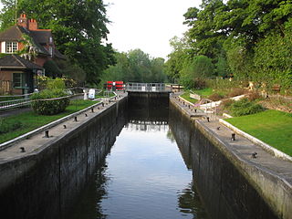
Marsh Lock is a lock and weir situated on the River Thames in England, about 1 mile upstream of Henley Bridge in Henley-on-Thames, Oxfordshire. The lock is close to the Berkshire bank, but accessed from the Oxfordshire side via two long walkways, the downstream one being near Mill Meadows. The first pound lock was built by the Thames Navigation Commission in 1773.

<span class="mw-page-title-main">Sonning Lock</span> Lock and weir on the River Thames in Berkshire, England

Sonning Lock is a lock and associated weir situated on the River Thames at the village of Sonning near Reading, Berkshire, England. The first lock was built by the Thames Navigation Commission in 1773 and it has been rebuilt three times since then. There is a weir a little upstream at the top of the island where Sonning Backwater separates from the main course of the river.

<span class="mw-page-title-main">Bray Lock</span> Lock and weir on the River Thames in Buckinghamshire, England

Bray Lock is a lock and weir on the River Thames in England near Bray and Dorney Reach, and is just above the M4 Bridge across the Thames. The lock is on the Buckinghamshire side of the river on the opposite bank from Bray itself and Maidenhead which are in Berkshire. Here, the county line stands roughly halfway between the lock and the opposite bank, following the course of the Thames itself. The pound lock was built by the Thames Navigation Commission relatively late, in 1845. The lock keeper's cottage is on an island between the lock and the weir.

<span class="mw-page-title-main">Whitchurch Lock</span> Lock and weir on the River Thames in Oxfordshire, England

Whitchurch Lock is a lock and weir on the River Thames in England. It is a pound lock, built by the Thames Navigation Commissioners in 1787. It is on an island near the Oxfordshire village of Whitchurch-on-Thames and is accessible only by boat.

<span class="mw-page-title-main">Shiplake Lock</span> Lock on the River Thames in Oxfordshire, England

Shiplake Lock is a lock and weir situated on the River Thames in England between the villages of Shiplake and Lower Shiplake, Oxfordshire. It is just above the points where the River Loddon joins the Thames and Shiplake Railway Bridge crosses the river. The first pound lock was built by the Thames Navigation Commission in 1773.

<span class="mw-page-title-main">Sonning Eye</span> Human settlement in England

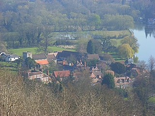
Sonning Eye is a hamlet on the River Thames in the Sonning Common ward of South Oxfordshire, England, in the civil parish of Eye & Dunsden, at what is since 1974 the southernmost tip of Oxfordshire.

<span class="mw-page-title-main">Thames Path</span> National Trail following the River Thames in England

The Thames Path is a National Trail following the River Thames from one of its sources near Kemble in Gloucestershire to the Woolwich foot tunnel, south east London. It is about 185 miles (298 km) long. A path was first proposed in 1948 but it only opened in 1996.

<span class="mw-page-title-main">Henley Bridge</span> Bridge in Henley-on-Thames

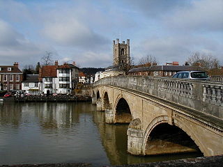
Henley Bridge is a road bridge built in 1786 at Henley-on-Thames over the River Thames, between Oxfordshire and Berkshire. The bridge has five elliptical stone arches, and links Hart Street in Henley with White Hill leading up a steep hill to Remenham Hill. It crosses the Thames on the reach between Hambleden Lock and Marsh Lock, carrying the Thames Path across the river. It is a Grade I listed building.

<span class="mw-page-title-main">Hambleden Lock</span> Lock on the River Thames in Berkshire, England

Hambleden Lock is a lock with a long weir situated on the River Thames in England, about 2 miles downstream of Henley Bridge. The lock is on the Berkshire bank between Aston and Remenham. Built by the Thames Navigation Commission in 1773, the lock is named after the village of Hambleden, a mile (1.5 km) to the north.

<span class="mw-page-title-main">Phillimore Island</span>

Phillimore Island is an elongated island in the River Thames in the county of Berkshire, England, near the villages of Shiplake, Oxfordshire and Wargrave, Berkshire. It is on the reach above Shiplake Lock.

<span class="mw-page-title-main">Culham Lock</span>

Culham Lock is a lock on the River Thames in England close to Culham, Oxfordshire. It is on a lock cut to the north of the main stream, which approaches the large village of Sutton Courtenay. The lock was built of stone by the Thames Navigation Commission in 1809.

<span class="mw-page-title-main">Radcot Lock</span>

Radcot Lock is a lock on the River Thames in England just downstream of Radcot, Oxfordshire, on the southern bank.

<span class="mw-page-title-main">Sonning Backwater Bridges</span> Bridge in Sonning Eye

Sonning Backwater Bridges are the road bridges across the first two of three branches of the Thames at Sonning Eye, Oxfordshire, England.

<span class="mw-page-title-main">Hennerton Backwater</span> River in England

Hennerton Backwater is a narrow backwater of the River Thames on the reach above Marsh Lock near the villages of Shiplake, Oxfordshire and Wargrave, Berkshire.

References

  1. River Thames Alliance. Bridge heights on the River Thames. Archived 24 January 2008 at the Wayback Machine
  2. Fred. S. Thacker The Thames Highway: Volume II Locks and Weirs 1920 - republished 1968 David & Charles
  3. David England and Tina Bilbe, Berkshire Folk Tales, Stroud: The History Press, 2013, ISBN   9780752492889.
  4. The Beautiful Sonning Bridges, The Sphere , page 275, 13 September 1902.
  5. Historic England. "Sonning Bridge (The Part Within Wokingham District, Berkshire) (1117436)". National Heritage List for England . Retrieved 5 August 2023.
  6. Tevye Markson (30 October 2019) [29 October 2019]. "Huge new £800k bid has been made for third Thames bridge to connect Reading and Oxfordshire". BerkshireLive. Retrieved 5 August 2023.
  7. "Third bridge plan doomed". Henley Standard. 8 July 2021. Retrieved 5 August 2023.
  8. Dave Gilyeat (26 July 2014). "Sonning Bridge postbox artist 'Impro' on his 'japes'". BBC News. Retrieved 26 July 2014.
  9. "Uri Geller mystified by letterbox on Thames Sonning Bridge". BBC News. 8 September 2013. Retrieved 5 August 2023.
  10. "Mystery of false door on bridge". Henley Standard. 30 August 2016. Retrieved 5 August 2023.
  11. "Prankster strikes again on bridge". Henley Standard. 25 April 2022. Retrieved 5 August 2023.
  12. "Urinal appears on the side of Sonning bridge over River Thames". BBC News. 5 August 2023. Retrieved 5 August 2023.
Next bridge upstream River Thames Next bridge downstream
Caversham Lock (pedestrian)Sonning Bridge
Grid reference SU755757
Shiplake Railway Bridge (rail)
Next bridge upstream Thames Path Next bridge downstream
southern bank
Whitchurch Bridge
Sonning Bridge &
Sonning Backwater Bridges
northern bank
Henley Bridge


51°28′32.5″N0°54′50″W / 51.475694°N 0.91389°W / 51.475694; -0.91389