Related Research Articles

Middlesex County is located in the Commonwealth of Massachusetts, in the United States. As of the 2020 census, the population was 1,632,002, making it the 22nd most populous county in the United States, and the most populous county in both Massachusetts and New England. Middlesex County is one of two U.S. counties to be amongst the top 25 counties with the highest household income and the 25 most populated counties. As part of the 2010 national census, the Commonwealth's mean center of population for that year was geo-centered in Middlesex County, in the town of Natick at. Middlesex County is included in the Census Bureau's Boston–Cambridge–Newton, MA–NH Metropolitan Statistical Area.

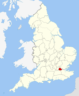
Middlesex is a historic county in southeast England. Its area is almost entirely within the wider urbanised area of London and mostly within the ceremonial county of Greater London, with small sections in neighbouring ceremonial counties. Three rivers provide most of the county's boundaries; the Thames in the south, the Lea to the east and the Colne to the west. A line of hills forms the northern boundary with Hertfordshire.
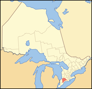
Middlesex County is a primarily rural county in Southwestern Ontario, Canada. Landlocked, the county is bordered by Huron and Perth counties on the north, Oxford County on the east, Elgin County on the south, and Chatham-Kent and Lambton County on the west.

The demography of England has since 1801 been measured by the decennial national census, and is marked by centuries of population growth and urbanization. Due to the lack of authoritative contemporary sources, estimates of the population of England for dates prior to the first census in 1801 vary considerably.
The County of London was a county of England from 1889 to 1965, corresponding to the area known today as Inner London. It was created as part of the general introduction of elected county government in England, by way of the Local Government Act 1888. The Act created an administrative County of London, which included within its territory the City of London. However, the City of London and the County of London formed separate ceremonial counties for "non-administrative" purposes. The local authority for the county was the London County Council (LCC), which initially performed only a limited range of functions, but gained further powers during its 76-year existence. The LCC provided very few services within the City of London, where the ancient Corporation monopolised local governance. In 1900, the lower-tier civil parishes and district boards were replaced with 28 new metropolitan boroughs. The territory of the county was 74,903 acres (303.12 km2) in 1961. During its existence there was a long-term decline in population as more residents moved into the outer suburbs; there were periodic reviews of the local government structures in the greater London area and several failed attempts to expand the boundaries of the county. In 1965, the London Government Act 1963 replaced the county with the much larger Greater London administrative area.
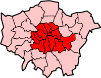
Inner London is the name for the group of London boroughs which form the interior part of Greater London and are surrounded by Outer London. With its origins in the bills of mortality, it became fixed as an area for statistics in 1847 and was used as an area of local government from 1855 to 1965 principally as the County of London or earlier as the Metropolitan Board of Works Area (metropolis). It now has two common definitions. The first is the statutory definition delineated in the London Government Act 1963, coming into force on 1 April 1965, comprising twelve Inner London boroughs and almost identical to the County of London that was abolished at the same time. The second is the current definition used by the Office for National Statistics comprising eleven of the statutory Inner London boroughs and two of the statutory Outer London boroughs, and the City of London.

The Metropolitan Borough of Finsbury was a Metropolitan borough within the County of London from 1900 to 1965, when it was amalgamated with the Metropolitan Borough of Islington to form the London Borough of Islington.

Islington was a civil parish and metropolitan borough in London, England. It was an ancient parish within the county of Middlesex, and formed part of The Metropolis from 1855. The parish was transferred to the County of London in 1889 and became a metropolitan borough in 1900. It was amalgamated with the Metropolitan Borough of Finsbury to form the London Borough of Islington in Greater London in 1965.

The Metropolitan Borough of Chelsea was a metropolitan borough of the County of London between 1900 and 1965. It was created by the London Government Act 1899 from most of the ancient parish of Chelsea. It was amalgamated in 1965 under the London Government Act 1963, with the Royal Borough of Kensington to form the Royal Borough of Kensington and Chelsea.

The Metropolitan Borough of Stoke Newington was a metropolitan borough in the County of London between 1900 and 1965 when it became part of the London Borough of Hackney.
Middlesex Centre is a township in Middlesex County, in southwestern Ontario, Canada, north and west of London. The Corporation of the Township of Middlesex Centre formed on January 1, 1998, with the amalgamation of the former Townships of Delaware, Lobo, and London. It is part of the London census metropolitan area.

Tilbrook is a village and civil parish in Cambridgeshire, England. Tilbrook lies approximately 10 miles (16 km) west of Huntingdon, near Covington. Tilbrook is situated within Huntingdonshire which is a non-metropolitan district of Cambridgeshire as well as being a historic county of England, although Tilbrook belongs historically to Bedfordshire.

Patrick Brompton is a village and civil parish in the Richmondshire district of North Yorkshire, England. Patrick Brompton is situated about 4 miles (6.4 km) west of Bedale. It lies on the A684. The population of the parish at the 2001 Census was 155, rising to 167 at the 2011 Census. North Yorkshire County Council estimated the population to be at 170 in 2015.

Edmonton is one of six hundreds of the historic county of Middlesex, England. A rotated L-shape, its area has been in the south and east firmly part of the urban growth of London. Since the 1965 formation of London boroughs it mainly corresponds to the London Boroughs of Enfield, a negligible portion of Barnet and a narrow majority of Haringey. Its ancient parish of South Mimms has since 1965 been part of the Hertsmere district in Hertfordshire.

Spelthorne was a hundred of the historic county of Middlesex, England. It contained these parishes and settlements:

Holborn was a local government district in the metropolitan area of London to the north west of the City of London from 1855 to 1900.
The ecclesiastical parish of Norton le Moors or Norton in the Moors is in the north-east of the city of Stoke-On-Trent, in the county of Staffordshire, England. The majority of the parish is within the city boundary, and the rest in the Staffordshire Moorlands district. Norton-in-the-Moors is also the name of a village-like suburb of the city, close to the 18th-century St Bartholomew's church.

Whinburgh and Westfield is a civil parish in the English county of Norfolk. It covers an area of 7.56 km2 (2.92 sq mi) and had a population of 307 in 134 households at the 2001 census. 10 years later it has a population of 342 according to the 2011 census. For the purposes of local government, it falls within the district of Breckland. The civil parish is located south of the nearby town Dereham and is formed from the two ancient parishes which centred round the churches of St Mary's Whinburgh and St Andrew's Westfield, and until 1894 the churches performed all the functions of local government. Norfolk was a county of small villages and parishes. The County of Norfolk Review Order, 1935, sought to rationalise this, and under this Westfield Parish was 'abolished' and merged with Whinburgh Parish. The name of the resultant parish was not changed from Whinburgh. For many years nothing was done about the parish's name, but on 2 August 1995, at the request of the Parish Council, Breckland Council sealed a 'Notice of the Change of Parish Name' and the parish then became Whinburgh and Westfield.
The United Kingdom Census of 1881 recorded the people residing in every household on the night of Sunday 3 April 1881, and was the fifth of the UK censuses to include details of household members.

Greater London is an administrative area in England governed by the Greater London Authority, and a ceremonial county that covers the bulk of the same area, with the exception of the City of London, which forms a separate ceremonial county. The administrative area, which has the same extent as the London Region, is organised into 33 local government districts: the 32 London boroughs and the City of London. The Greater London Authority, based in Newham as of the start of 2022, is responsible for strategic local government across the area and consists of the Mayor of London and the London Assembly.
References
- ↑ "Table of population, 1801–1901". A History of the County of Middlesex: Volume 22. 1911. Retrieved 20 February 2008.