
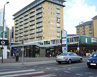
Hounslow is a large suburban district of West London, 10.7 miles (17.2 km) west-southwest of Charing Cross. It is the administrative centre of the London Borough of Hounslow, and is identified in the London Plan as one of the 12 metropolitan centres in Greater London.

Brentford is a suburban town in West London, England and part of the London Borough of Hounslow. It lies at the confluence of the River Brent and the Thames, 8 miles (13 km) west of Charing Cross.

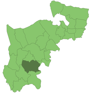
The London Borough of Hounslow is a London borough in West London, England, forming part of Outer London. It was created in 1965 when three smaller Middlesex council areas amalgamated under the London Government Act 1963. It is governed by Hounslow London Borough Council.
Feltham is a town in West London, England, 13 miles (21 km) from Charing Cross. Historically part of Middlesex, it became part of the London Borough of Hounslow in 1965. The parliamentary constituency of Feltham and Heston has been held by Labour Party MPs since 1992. In 2011, the population of the combined census area of Feltham, Bedfont and Hanworth was 63,368.
Heston is a suburban area and part of the Hounslow district in the London Borough of Hounslow. The residential settlement covers a slightly smaller area than its predecessor farming village, 10.8 miles (17.4 km) west south-west of Charing Cross and adjoins the M4 motorway but has no junction with it; Heston also adjoins the Great West Road, a dual carriageway, mostly west of the 'Golden Mile' headquarters section of it. Heston was, historically, in Middlesex.

Isleworth is a town located within the London Borough of Hounslow in West London, England. It lies immediately east of the town of Hounslow and west of the River Thames and its tributary the River Crane. Isleworth's original area of settlement, alongside the Thames, is known as 'Old Isleworth'. The north-west corner of the town, bordering on Osterley to the north and Lampton to the west, is known as 'Spring Grove'.
Osterley is an affluent district of the historic parish of Isleworth in west London approximately 9.5 miles (15.3 km) west south-west of Charing Cross and is part of the London Borough of Hounslow. Most of its land use is mixed agricultural and aesthetic parkland at Osterley House, charity-run, much of which is open to paying visitor access.

Middlesex is a historic county in southeast England. Its area is almost entirely within the wider urbanised area of London and mostly within the ceremonial county of Greater London, with small sections in neighbouring ceremonial counties. Three rivers provide most of the county's boundaries; the Thames in the south, the Lea to the east and the Colne to the west. A line of hills forms the northern boundary with Hertfordshire.

The River Crane, a tributary of the Thames, runs 8.5 miles (13.6 km) in Middlesex, England. It is in effect the lower course of the Yeading Brook. It adjoins or bisects three London boroughs: Hillingdon, Hounslow and Richmond upon Thames. The drainage basin is heavily urbanised but many of the Hayes to Whitton flood-meadows have been conserved, forming a narrow, green vale, opening out to what remains of Hounslow Heath in the centre – a near-continuous belt of semi-natural habitat.
Heston and Isleworth was a local government district of Middlesex, England from 1894 to 1965.

The Duke of Northumberland's River or D. O. N. River consists of separate upper and lower artificial watercourses in west London, United Kingdom. The older name Isleworth Mill Stream/River more accurately describes the economic motivation behind its construction. The first section draws water via a sluice from the Colne — a source river which has seven distributaries, many of which are man-made — today an extended distance of about 5 miles (8 km) into the Crane; its lower section of about 1.8 miles (2.9 km) draws water from that small river in Whitton, Twickenham and discharges it via neighbouring Isleworth, passing Mill Plat into the tidal Thames. A sluice underneath Mill Plat feeds the main lake in Syon Park.

Isleworth & Syon School is a non-denomination secondary school and sixth form for boys aged 11 to 18 years old. Girls are admitted to the school's sixth form, which is part of a consortium with other secondary schools in the borough. The school is situated on Ridgeway Road, Isleworth, within the London Borough of Hounslow, England. It is close to the A4, just south of Osterley Park. It has many travel links including Isleworth railway station, Osterley tube station and London Buses

Heston and Isleworth was a constituency between 1945 and 1974 for the House of Commons of the UK Parliament. It contained Heston, Hounslow, Isleworth and Osterley in Middlesex which became parts of outer west London in 1965.

Spelthorne was a hundred of the historic county of Middlesex, England. It contained these parishes and settlements:

Fulwell is a neighbourhood of outer South West London in the historic County of Middlesex and the London Borough of Richmond upon Thames. It straddles the west of the generally firmer borders of Twickenham and Teddington, reinforced as local postcode districts. The name is first known in documents of the fifteenth century. It may be from a reliably full well or a corruption of foul well.
Gillette Corner is a crossroads in west London. It is where a straightened medieval route Syon Lane (B454) crosses the triple carriageway of the Great West Road A4 and is the western end of the West Cross business district. A disused name for the neighbourhood is Syon Hill.
Kempton Park, England formerly an expanded manor known as Kempton, Kenton and other forms, today refers to the land owned by the Jockey Club: Kempton Park nature reserve and Kempton Park Racecourse in the Spelthorne district of Surrey. Today's landholding was the heart of, throughout the Medieval period, a private parkland – and its location along with its being a royal manor rather than ecclesiastic, or high-nobility manor led to some occasional residence by Henry III and three centuries later hunting among a much larger chase by Henry VIII and his short-reigned son, Edward VI.

St Leonard's Church is the Grade II* listed Church of England parish church for Heston in the London Borough of Hounslow.

St Mary's Church, Osterley is a Church of England church on Osterley Road in Osterley, London Borough of Hounslow.


