
Middlesex was a county in southeast England. Its area was almost entirely within the wider urbanised area of London and mostly within the ceremonial county of Greater London, with small sections in neighbouring ceremonial counties. The county's boundaries largely followed three rivers: the Thames in the south, the Lea to the east and the Colne to the west. A line of hills formed the northern boundary with Hertfordshire.

The Metropolitan Borough of Chelsea was a metropolitan borough of the County of London between 1900 and 1965. It was created by the London Government Act 1899 from most of the ancient parish of Chelsea. Following the London Government Act 1963, it was amalgamated with the Royal Borough of Kensington in 1965 to form the Royal Borough of Kensington and Chelsea.

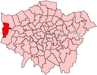
Spelthorne is a local government district with borough status in Surrey, England. Its council is based in Staines-upon-Thames; other settlements in the area include Ashford, Sunbury-on-Thames, Shepperton, Stanwell and Laleham. It is named after the medieval Spelthorne Hundred which had covered the area.

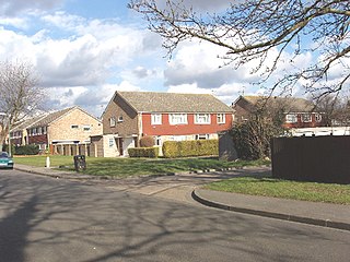
Ashford is a town in Surrey, England, 14 mi (23 km) west of central London. Its name derives from a crossing point of the River Ash, a distributary of the River Colne. Historically part of Middlesex, the town has been part of Surrey since 1965. Ashford consists of relatively low density low- and medium-rise buildings, none of them being high rise. If excluding apartments most houses are semi-detached.

Shepperton is a village in north Surrey, England, around 15 mi (24 km) south west of central London. On the north bank of the River Thames, the settlement is in the Borough of Spelthorne, it is between the towns of Chertsey and Sunbury-on-Thames. The village is mentioned in a document of 959 AD and in the Domesday Book.

Upper Halliford is a small village in the Borough of Spelthorne, Surrey, England approximately 24 km (15 mi) west of central London. It is part of the Shepperton post town and is in the Metropolitan Green Belt. The closest settlements are Shepperton, Charlton and Walton on Thames. St Andrew’s Baptist Church is in the southern part of the village and the settlement is in the ecclesiastical Parish of Sunbury on Thames. The conservation area surrounds the village green.

Stanwell is a village in the Borough of Spelthorne, Surrey, England. It is 16 miles (26 km) west of central London. A small corner of its land is used as industrial land for nearby Heathrow Airport. The rest of the village is made up of residential and recreational land. Historically part of the county of Middlesex, it has, like the rest of Spelthorne, been in Surrey since 1965. The village is to the south of the cargo-handling area of Heathrow Airport and to the east of the Staines Reservoirs. Stanwell is the northernmost settlement in Surrey, bordering Berkshire and Greater London.

Spelthorne is a constituency in Surrey represented in the House of Commons of the UK Parliament since 2010 by Kwasi Kwarteng, a Conservative, who served as Chancellor of the Exchequer for 38 days in September and October 2022.
Uxbridge was a seat returning one Member of Parliament (MP) of the House of Commons of the UK Parliament from 1885 to 2010. Its MPs elected were: Conservative Party candidates for 107 years and Labour Party candidates for 18 years. The closing 40 years of the seat's history saw Conservative victory — in 1997 on a very marginal majority in relative terms.
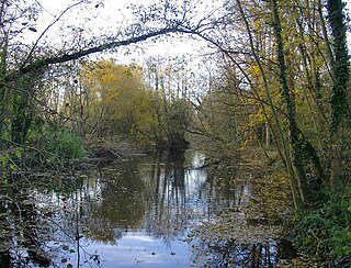
The River Ash is a small, shallow river in Surrey, England. Its course of 10 kilometres (6.2 mi) is just outside Greater London. Work has been carried out to re-align, clear and build up a small, Littleton head of water and create two backwaters. One backwater dates to the medieval period; the other to the 1990s. It flows as one of the six distributaries of the River Colne from the south of Staines Moor immediately south of the Staines Bypass eastwards through the rest of the borough of Spelthorne before meeting the River Thames.

Elthorne was a hundred of the historic county of Middlesex, England.

Wheatley's Ait or Wheatley Eyot is an ait (island) in the River Thames of approximately 8 hectares on the reach above Sunbury Lock, close to the northern side and in the post town Sunbury-on-Thames however in the Borough of Elmbridge in Surrey, England.

Staines Rural District was a rural district of Middlesex in England from 1894 to 1930.
Stanwell Moor is a village and moor in the Borough of Spelthorne, approximately 17 miles (27 km) west of central London. Historically part of the county of Middlesex, it was transferred to Surrey in 1965. West of its generally narrow moor is the M25 London Orbital Motorway and the village is 1 mile (1.6 km) southwest of Heathrow Airport Terminal 5.

Edmonton is one of six hundreds of the historic county of Middlesex, England. A rotated L-shape, its area has been in the south and east firmly part of the urban growth of London. Since the 1965 formation of London boroughs it mainly corresponds to the London Boroughs of Enfield, a negligible portion of Barnet and a narrow majority of Haringey. Its ancient parish of South Mimms has since 1965 been part of the Hertsmere district in Hertfordshire.

Isleworth Hundred was a subdivision of the historic county of Middlesex, England. In Domesday Book (1086) it was recorded as Hundeslaw Hundred.
Kempton Park, England formerly an expanded manor known as Kempton, Kenton and other forms, today refers to the land owned by the Jockey Club: Kempton Park nature reserve and Kempton Park Racecourse in the Spelthorne district of Surrey. Today's landholding was the heart of, throughout the Medieval period, a private parkland – and its location along with its being a royal manor rather than ecclesiastic, or high-nobility manor led to some occasional residence by Henry III and three centuries later hunting among a much larger chase by Henry VIII and his short-reigned son, Edward VI.
Littleton is a village in the Borough of Spelthorne, approximately 16 mi (26 km) west of central London. Historically part of the county of Middlesex, it was transferred to Surrey in 1965. It is the location of Shepperton Studios.

Staines Moor is a 510.8-hectare (1,262-acre) biological Site of Special Scientific Interest north of Staines-upon-Thames in Surrey. It is part of the South West London Waterbodies Ramsar site and a Special Protection Area
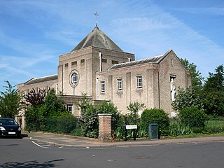
St Mark's, Teddington, the parish church of South Teddington and Hampton Wick, is a Church of England church in the liberal Catholic tradition. It is located on St Mark's Road, Teddington in the London Borough of Richmond upon Thames. The current building dates from 1939 and was designed by architect Cyril Farey.


