
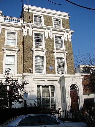
John Claudius Loudon was a Scottish botanist, garden designer and author. He was the first to use the term arboretum in writing to refer to a garden of plants, especially trees, collected for the purpose of scientific study. He was married to Jane Webb, a fellow horticulturalist, and author of science-fiction, fantasy, horror, and gothic stories.

Lancaster Gate is a mid-19th century development in the Bayswater district of central London, immediately to the north of Kensington Gardens. It consists of two long terraces of houses overlooking the park, with a wide gap between them opening onto a square containing a church. Further terraces back onto the pair overlooking the park and loop around the square. Until 1865 the terraces were known as Upper Hyde Park Gardens, with the name Lancaster Gate limited to the square surrounding the church. The development takes its name from Lancaster Gate, a nearby entrance to Kensington Gardens, itself named in honour of Queen Victoria as Duke of Lancaster.
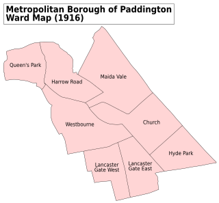
Westbourne is an area in West London. It has a manorial history spanning many centuries, within a more broadly defined Paddington, before shedding its association in the mid-19th century. It is named after the west bourne, West Bourne, or River Westbourne, a Thames tributary which was encased in 19th-century London in the 1850s. The spring-fed stream and associated manor have led to the place names Westbourne Green, Westbourne Park and more narrowly: Westbourne Gardens, Westbourne Grove, Westbourne Park Road, Westbourne Park tube station, Westbourne Studios and the name of a public house.
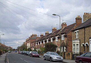
Kingston Road is a road in Oxford, England. It continues north from Walton Street, at the junction with Walton Well Road to the west and St Bernard's Road to the east, running parallel with and to the west of Woodstock Road. Kingston Road is the main road in Walton Manor. At the northern end, there is a staggered junction with Aristotle Lane to the west and Polstead Road to the east. The road continues as Hayfield Road. Southmoor Road and Southmoor Place lead off Kingston Road to the west.

Leinster Gardens is a street in Bayswater, London. It is lined with tall, ornate, mid-Victorian terraced houses, many of which are listed buildings.
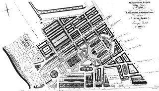
Tyburnia, a part of Paddington in London, originally developed following an 1824 masterplan drawn up by Samuel Pepys Cockerell (1753–1827) to redevelop the historic lands of the Bishop of London, known as the Tyburn Estate, into a residential area to rival Belgravia. Tyburnia was the first part of Paddington to be developed.

Porchester Square is an archetypal-format, narrow London garden square in Bayswater on the cusp of inter-related Westbourne. It is lined with tall white Victorian classical architecture residential buildings.
George Gutch (1790-1894) was a British architect and to four successive Bishops of London surveyor for much of the Diocese's c. 500-acre (2.0 km2) southern strip of the parish of Paddington.
Harley Gardens is a residential street in Chelsea, London SW10. It runs roughly north to south from Priory Walk to Milborne Grove, parallel to the west of Drayton Gardens, and lies just north of Fulham Road.

Masbro Road is in the London Borough of Hammersmith, England. It runs from Sinclair Road in the north to Blythe Road in the south. It is joined on the west side by Fielding Road, Irving Road, Redan Street, and Springvale Terrace. It is joined on the east side by Hofland Road and crossed by Milson Road.

Hyde Park Gardens Mews is a mews street in the Bayswater area of London, W2. The mews consists of 46 residential properties, originally built as stables for Hyde Park Gardens, on a cobbled road with two entrances. The west entrance passes under an archway. The mews is entered by Clarendon Place at the west and Stanhope Terrace to the east. Sussex Place bisects the mews in the middle.
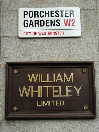
Porchester Gardens is a street in the Bayswater area of London. Located in the City of Westminster, it runs east to west and crosses Queensway. Like several streets in the area it was developed by Edward Orme. In 1879 the engineer R. E. B. Crompton lit his house by electricity, effectively the first in London to do so. The department store Whiteleys was located where the two streets joined before its closure. The road features a mixture of residential and commercial properties. At the eastern end, Porchester Terrace runs southwards to Kensington Gardens while in the west it ultimately merges into Kensington Gardens Square and Leinster Square. Moscow Road runs parallel to the south for much of the route.

Gloucester Terrace is a street in Central London in the vicinity of Paddington and Bayswater. Located in the City of Westminster, it runs northwards from Lancaster Terrace near to Lancaster Gate tube station and Hyde Park before curving round to meet Porchester Square around Westbourne. The southern section is close to the border between Tyburnia and Bayswater. It intersects with Craven Road, Chilworth Street, Cleveland Terrace, Bishop's Bridge Road and Orsett Terrace. Its northern section is close to the Great Western Main Line and Westway. Westbourne Terrace runs directly parallel to the east.

Sussex Gardens is located in Paddington in Central London. It is a street that runs runs westwards from the Edgware Road, for most of the way as a broad avenue until it reaches an area near Lancaster Gate where it becomes a garden square. Part of the City of Westminster, it is located in the residential area of Tyburnia north of Hyde Park. Streets running off it include Westbourne Terrace, Talbot Square, London Street and Southwick Street. Sussex Gardens provides the main axis for the area.

Carlton Vale is a street that runs through Kilburn and Maida Vale in London. Some of its route forms the boundary between the City of Westminster to the south and the London Borough of Brent to the north. To the west the street continues as Kilburn Lane through Queen's Park, while to the east it becomes Carlton Hill running into St. John's Wood. Carlton Vale crosses or meets several roads including Kilburn Park Road, Cambridge Road and Randolph Avenue.

Norfolk Square is a rectangular garden square in Paddington in Central London. Located in the City of Westminster, it is part of the Tyburnia district north of Hyde Park. It runs east to west from London Street to Norfolk Place. Praed Street and Sussex Gardens are directly parallel to it north and south respectively.

Sussex Square is a garden square in Paddington in Central London. Located in the City of Westminster, it is part of the Tyburnia area north of Hyde Park. Stanhope Terrace runs along its southern side.

Albion Street is a residential street located in Central London in the City of Westminster. Part of the Tyburnia area, it runs southwards from Connaught Street to the Bayswater Road on the edge of Hyde Park. It is notable for its Regency architecture.

Belsize Lane is a street in the Belsize Park area of Hampstead in London. Located in the London Borough of Camden, it runs east to west from Haverstock Hill to Fitzjohns Avenue. While residential for much of the route, it also features a group of commercial properties that form the centre of Belsize Village. The Tavistock Clinic is located at its western end.

Pond Street is located in Hampstead in the London Borough of Camden. It runs eastwards from Rosslyn Hill to South End Green, located in the old "South End" of the settlement. The street takes its name from an ancient pond at South End Green, a source of the River Fleet, and has been known by this name since at least 1678. The pond survived into the Victorian era.


