Related Research Articles

Vancouver Island is an island in the northeastern Pacific Ocean and part of the Canadian province of British Columbia. The island is 456 km (283 mi) in length, 100 km (62 mi) in width at its widest point, and 32,100 km2 (12,400 sq mi) in total area, while 31,285 km2 (12,079 sq mi) are of land. The island is the largest by area and the most populous along the west coasts of the Americas.

Bodega Bay is a shallow, rocky inlet of the Pacific Ocean on the coast of northern California in the United States. It is approximately 5 mi (8 km) across and is located approximately 40 mi (60 km) northwest of San Francisco and 20 mi (32 km) west of Santa Rosa. The bay straddles the boundary between Sonoma County to the north and Marin County to the south. The bay is a marine habitat used for navigation, recreation, and commercial and sport fishing.

George Dixon was an English sea captain, explorer, and maritime fur trader. George Dixon was "born in Leath Ward, a native of Kirkoswald". The son of Thomas Dixon, he was baptised in Kirkoswald on 8 July 1748.
The Nootka Sound Conventions were a series of three agreements between the Kingdom of Spain and the Kingdom of Great Britain, signed in the 1790s, which averted a war between the two countries over overlapping claims to portions of the Pacific Northwest coast of North America.
Chatham Strait, or Shee ya xhaak in the Tlingit language, is a narrow passage of the Alexander Archipelago in the southeastern region of the U.S. state of Alaska. It separates Chichagof Island and Baranof Island to its west from Admiralty Island and Kuiu Island on its east.
Kruzof Island is an island in the Alexander Archipelago in southeastern Alaska at 57°10′14″N135°40′29″W. It is about 16 km (10 mi) west of Sitka, and is part of the City and Borough of Sitka. It was named in 1805 by Captain U.T. Lisianski as Crooze Island, after a Russian Admiral. It hosts the region's only volcano, Mount Edgecumbe.

Juan Francisco de la Bodega y Quadra was a Spanish Criollo naval officer operating in the Americas. Assigned to the Pacific coast Spanish Naval Department base at San Blas, in Viceroyalty of New Spain, he explored the Northwest Coast of North America as far north as present day Alaska. Bodega Bay in California is named for him.
Juan José Pérez Hernández, often simply Juan Pérez, was an 18th-century Spanish explorer. He was the first known European to sight, examine, name, and record the islands near present-day British Columbia, Canada. Born in Palma de Mallorca, Spain, he first served as a piloto in western Spanish colonial North America on Manila galleons en route to and from the Philippines in the Spanish East Indies. In 1768, he was assigned to the Pacific port of San Blas, in the Viceroyalty of New Spain, and acquired the rank of ensign (alférez).
Bruno de Heceta (Hezeta) y Dudagoitia (1743–1807) was a Spanish Basque explorer of the Pacific Northwest. Born in Bilbao of an old Basque family, he was sent by the viceroy of New Spain, Antonio María Bucareli y Ursúa, to explore the area north of Alta California in response to information that there were colonial Russian settlements there.
During the Age of Exploration, the Spanish Empire undertook several expeditions to the Pacific Northwest of North America. Spanish claims to the region date to the papal bull of 1493, and the Treaty of Tordesillas signed in 1494. In 1513, this claim was reinforced by Spanish explorer Vasco Núñez de Balboa, the first European to sight the Pacific Ocean, when he claimed all lands adjoining this ocean for the Spanish Crown. Spain only started to colonize the claimed territory north of present-day Mexico in the 18th century, when it settled the northern coast of Las Californias.

Esteban José Martínez Fernández y Martínez de la Sierra, or simply José Esteban Martínez (1742–1798) was a Spanish naval officer, navigator and explorer, native of Seville. He was a key figure in the Spanish exploration of the Pacific Northwest and the Nootka Crisis.
Francisco de Eliza y Reventa was a Spanish naval officer, navigator, and explorer. He is remembered mainly for his work in the Pacific Northwest. He was the commandant of the Spanish post in Nootka Sound on Vancouver Island, and led or dispatched several exploration voyages in the region, including the Strait of Juan de Fuca and the Strait of Georgia.

Francisco Antonio Mourelle de la Rúa was a Spanish naval officer and explorer from Galicia serving the Spanish crown. He was born in 1750 at San Adrián de Corme, near A Coruña, Galicia.
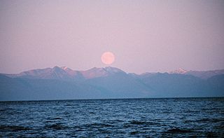
Bucareli Bay is a bay in the Alexander Archipelago, in the southeastern part of the U.S. state of Alaska. It is located off the western coast of Prince of Wales Island, between Baker Island and Suemez Island. To the east it connects to various waterways, such as San Alberto Bay. To the west it opens directly upon the Pacific Ocean. Bucareli Bay is about 25 miles (40 km) long.
The King George's Sound Company, also known as Richard Cadman Etches and Company after its "prime mover and principal investor", was an English company formed in 1785 to engage in the maritime fur trade on the northwest coast of North America. The company had nine partners in 1785: Richard Cadman Etches, John Hanning, William Etches, Mary Camilla Brook, William Etches, John Etches, Nathaniel Gilmour, Nathaniel Portlock (captain), and George Dixon (captain). No change in the list of partners after 1785 has been found.

La Princesa was a Spanish frigate or corvette built at the Spanish naval base at San Blas and launched in 1778. She is sometimes called a frigate and sometimes a corvette. At the time a corvette was similar to a frigate in that both were three-masted, ship-rigged warships, but corvettes were slightly smaller and had a single deck instead of two. The exact specifications of La Princesa are not known. La Princesa was designed with storage enough to sail for a year without having to restock. She was built for durability rather than speed. Like La Favorita, a similar corvette stationed at San Blas, La Princesa was heavily used, serving for over three decades, playing an important role in the exploration of the Pacific Northwest as well as the routine work of provisioning the missions of Alta California. During her 1779 voyage the Princesa carried six four-pounder cannons and four three-pounders, and had a crew complement of 98. The Princesa carried 26 cannons in 1789 when Esteban José Martínez took control of Nootka Sound.
Ignacio de Arteaga y Bazán was an officer of the Spanish Navy.
James Colnett was an officer of the British Royal Navy, an explorer, and a maritime fur trader. He served under James Cook during Cook's second voyage of exploration. Later he led two private trading expeditions that involved collecting sea otter pelts in the Pacific Northwest of North America and selling them in Canton, China, where the British East India Company maintained a trading post. Wintering in the recently discovered Hawaiian Islands was a key component of the new trade system. Colnett is remembered largely for his involvement in the Nootka Crisis of 1789—initially a dispute between British traders and the Spanish Navy over the use of Nootka Sound on Vancouver Island that became an international crisis that led Britain and Spain to the brink of war before being peacefully resolved through diplomacy and the signing of the Nootka Conventions.
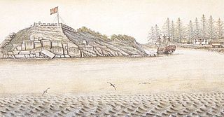
Santa Cruz de Nuca was a Spanish colonial fort and settlement and the first European colony in what is now known as British Columbia. The settlement was founded on Vancouver Island in 1789 and abandoned in 1795, with its far northerly position making it the "high-water mark" of verified northerly Spanish settlement along the North American west coast. The colony was established with the Spanish aim of securing the entire west coast of the continent from Alaska southwards, for the Spanish crown.
North West America was a British merchant ship that sailed on maritime fur trading ventures in the late 1780s. It was the first non-indigenous vessel built in the Pacific Northwest. In 1789 it was captured at Nootka Sound by Esteban José Martínez of Spain during the Nootka Crisis, after which it became part of the Spanish Navy and was renamed Santa Gertrudis la Magna and later Santa Saturnina.
References
- ↑ U.S. Geological Survey Geographic Names Information System: Port Etches
- ↑ Tovell, Freeman M. (2008). At the Far Reaches of Empire: The Life of Juan Francisco De La Bodega Y Quadra. University of British Columbia Press. pp. 94–95. ISBN 978-0-7748-1367-9.
Coordinates: 60°19′49″N146°36′16″W / 60.33028°N 146.60444°W